Good Day for a Summit
Sweeney Peak – 9,162’
Elevation Gain – 3,542’
Ascent Date – 14jul06
Total Route Time – an unhurried 6 hour stroll
The Trip Report
Though most driving directions to the Sweeney Creek Trailhead say to turn west from US Hwy 93 onto Sweeney Creek Road, it turns out the name on the road sign is Sweeney Creek Loop. Whether the name has been changed, or the directions though oft-repeated are incorrect, is anyone’s guess. Nonetheless, getting to the trailhead was a pretty easy uphill drive on fairly a good gravel road, though it looked like no one had done any work on it for some time. There are a couple of places toward higher elevations which have turned to pretty bad mud holes or begun to erode on the down-hill side of the road.
![Ridgeline]() View to the south of Sweeney Creek Trail.
View to the south of Sweeney Creek Trail.
The Sweeney Creek Trail is the steepest section of the route to the peak – hard on the thighs and lungs during the ascent, and crunches your toes during the descent. Still, the scenery to the south of the trail makes it well worth it. There are even a few strategically placed lookout points along the trail offering picture-taking opportunities.
We left the official Sweeney Creek Trail 393 at a point about 2.3 miles from the trail head. This spot is a little past the high-point of the trail, just where a small stream crosses the trail. If you look to your right
(north) immediately after stepping over the stream, there is an obvious trail leading uphill into the trees.
(It looks to me as if someone, possibly a hunter, has established a place to set up a tent or two.) We followed the established but faint trail through the underbrush as it meandered northwest, traversing along the side of the ridgeline. At some point we lost the trail altogether, so just kept moving gradually uphill in a northwesterly direction. Periodically, as the trees thinned, we would find (and follow) faint trail sections which were going in the direction we wished.
![St Joseph]() A good view of St Joseph.
A good view of St Joseph.
Eventually we broke from the thicker woods and attained the obvious ridgeline. As we moved along to higher and higher elevations, we had good views into the One Horse drainage which lies immediately to the north. Now sections of trail were becoming more and more obvious, so we knew others had been there before us.
Along with our gain in elevation, the trees turned from fir and lodgepole to a mixture of whitebark pine and larch. In my opinion, one of the highlights of the route was when we reached an area which was populated almost exclusively with widely-spaced larch. If it wasn’t for the lack of water, it looked to be a great place to camp. Of course a person could always carry the necessary water…
![False Summit]() Looking through the larch at the false summit.
Looking through the larch at the false summit.
As we moved upward through the ever-thinning larch, the ground was covered with flowering Mountain Heather. Unfortunately, it was so windy I was unable to get any good pictures. At this point we could see the false summit and the pretty obvious route to its base. It was apparent others had similar ideas, as from this point on, the multiple trails seemed for the most part to merge into a single track.
![False Summit]() The false summit.
The false summit.
Working our way over and through a couple of boulder fields, snow fields, and Mountain Heather, we reached the base of the false summit. We stayed towards the left side of the exposed rocks as we ascended. Obviously others before us had done the same, as a faint trail was visible in the small sections of scree.
![Ridgeline to Summit]() Ridgeline to the summit.
Ridgeline to the summit.
After topping the false summit, the route to the true summit was readily discernable along the undulating ridgeline. From this point forward there was little change in elevation – just a walk in the park! I reached the summit enough ahead of my wife so that I was able to take a picture of her boulder-hopping way toward me.
![Gorp and Gatorade]() GORP and Gatorade for lunch
GORP and Gatorade for lunch
The wind was very strong from the southwest
(gusts strong enough to knock us off balance) as we walked along the ridgeline and when we reached the summit. So we hunkered down on the north-facing side of and just below the summit for a leisurely bite to eat before beginning the trip down.
![Relaxing]() Time to relax.
Time to relax.
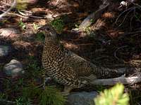
Just for fun, I’d stashed a bottle of Gatorade in a snow bank a few hundred yards below the false summit. It was nice and cold when re returned from the summit. Yum! The wind was still too strong for taking pictures of flowers. It would have to wait until next time. Other than that, the descent was rather uneventful until we reached the more thickly wooded section of the trail, at which point a mother grouse was kind enough to pose for a few pictures as she tried to keep us from noticing her chicks.
![Grouse]() Mother grouse
Mother grouse
Once we returned to the official Sweeney Creek Trail, we began the slog back to the trailhead, cramming our toes ever-more painfully into our hiking boots, thinking all the while of those sandals waiting in our car.
Comments
No comments posted yet.