
|
|
Trailhead |
|---|---|
|
|
42.58519°N / 109.08626°W |
|
|
Sublette |
|
|
Summer, Fall |
|
|
8890 ft / 2710 m |
Overview
 Sweetwater Gap signboard-(just where Finis said it would be)
 Little Sandy Tr=orange Sweetwater Gap Tr=red
This remote, seldom used trailhead provides access to the extreme southern reaches of the Wind River Range, north of South Pass. Two trails lead into two different wilderness areas from the TH- the Little Sandy Trail leads to Little Sandy Lake in the Bridger Wilderness and the Sweetwater Gap Trail leads to the Sweetwater Gap and the Popo Agie Wilderness.
Some information available at the time of this writing indicates that the Little Sandy Trail is little used and hard to follow due to deadfall from the fires of 1988. Other sources state that the trail is hard to follow in places, but serviceable. See the comments section of this page for detail on the Little Sandy Trail issues. I would suggest contacting Bridger-Teton National Forest for current conditions on both the Little Sandy and Sweetwater Gaps trails.
The Sweetwater Gap trail also passes through portions of the 1988 burn areas. The trail does show evidence of maintenance to clear deadfall, though it would appear that at least as of August 9th, 2008, those efforts have fallen behind. For the most part it’s a nuisance, but in a few spots it’s a bit tricky and time consuming to get through. The good news is that, after about 3 miles, you’ll leave the burn area behind and find a good trail to the Gap.
There are no facilities or water at the TH.
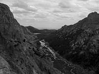
 Burn area along the Sweetwater Gap Trail
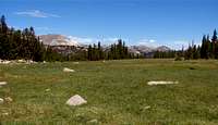 Looking north from the Sweetwater Gap
Directions
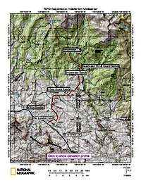 TH access road map
From Wyo Hwy 28, turn north onto the Sweetwater Road, which is approx. 43 miles from Lander or 33.5 miles from Farson. The turnoff is well signed for the Sweetwater Gap Ranch and the Big Sandy Entrance. See the comments section for a different perspective on directions. Drive north for approx. 15 miles to a signed intersection that is signed for the White Acorn Ranch, Sweetwater Ranch, Sweetwater Campground and the Sweetwater Guard Station. Turn right. Continue straight at a junction after another 3.3 miles to a signed junction for SW Gap Ranch, SW Guard Station and Sweetwater CG, go left. After another 2.5 miles the road T’s, right goes to the Guard Station & campground, left goes to the TH. The quality of the road to the TH deteriorates as it makes it’s way for approx. 2 miles to the end of the line. It’s not too bad but high clearance is required and 4WD would be preferable.
Destinations
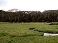
 Little Sandy Lake and Creek, from the north.
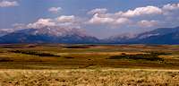 Looking north toward the Sweetwater Gap from Hwy 28 (the Lander Cut-Off)
Via the Little Sandy Trail:
Little Sandy Lake-4.1 miles
Via the Sweetwater Gap Trail:
Sweetwater Gap-6.3 miles
Tayo Park-8.1 miles
Poison Lake-9.8 miles
Deep Creek Jct.-13.1 miles
Pinto Park Trail-14.7 miles
Tayo Lake-11.8 miles
Mountain Links
Wind River Peak
Mount Nystrom
Camping options
There are some undeveloped camping areas along the last couple miles to the TH in addition to the small Sweetwater Campground. There is no water available at the campground.Guidebooks/Maps
 Tayo Park
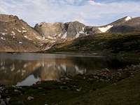 Tayo Lake,with Wind River Peak, upper right
Select Peaks of Greater Yellowstone by Thomas Turiano (2003) Indomitus Books, Jackson, WY. SummitPost Gear Review
Climbing and Hiking in the Wind River Mountains by Joe Kelsey Chockstone Press SummitPost Gear Review
Wyoming's Wind River Range by Joe Kelsey American Geographic Publishing an overview of the range with many great photos
Hiking Wyoming's Wind River Range by Ron Adkison Falcon Press a fairly detailed trail guide with a smattering of climbing and fishing info
Walking the Winds by Rebecca Woods White Willow Publishing a hiking guide with some fishing info
Wind River Trails by Finis Mitchell (1975) Wasatch Publishers,INC. an old school trails/climbing/fishing guide by Mr. Wind River himself
Wind River Hiking Map and Guide* Earth Walk Press SummitPost Gear Review
*The Earth Walk map of the Southern Winds does not quite reach as far south as this TH.
Red Tape
The only permits required at this time are for organized groups and campers with pack or saddle stock.Bridger Wilderness Regulations
Popo Agie Wilderness Regulations
Safety
 Larsen Creek Bridge
 MF Popo Agie crossing at Tayo Park, August 8th, 2008
While bridges are few and far between in the Winds, the SW Gap trail starts off with one that spans Larsen Creek. Stream crossings are less of a concern in this extreme southern end of the Winds than they are in the central and northern portions, but they are still something you’ll have to deal with. Early in the season, the MF of the Popo will be much deeper and faster flowing, than it appears in this photo taken at the Tayo Park ford.
Glacier travel is also less of an issue in the southern reaches of the Winds. Still, if your route includes it, plan on carrying the proper equipment and know how to use it.
Due to the remoteness of this TH, emergency assistance will take longer to reach those in need of it. Solo travel carries additional risk as this article from Backpacker Magazine illustrates: The Mike Turner Story
Links for Weather and other related info
Weatherunderground-Conditions at Pinedale/ Forecast for Eastern Wind River MountainsNOAA
Wyoming Streamflows
Snowpack Data
Wyoming Road Conditions/Hwy Web Cams
laurelnfred - Sep 13, 2008 4:31 pm - Hasn't voted
Some info and clarificationsA couple of comments on Sweetwater Gap area. At the risk of increasing traffic in the area... We just returned from a loop into Little Sandy Lake and out Sweetwater Gap. It was very nice but I would do it in a 7 day/6 night trip instead of the 5 day/4 night trip we did. It's important to have good route finding skills and have good maps. A couple clarifications on the directions to the trailhead. Follow the signs for Sweetwater campground/ranger station. (We saw no signs for any of the ranches until quite a way in) You'll eventually come to a fork in the road where there is a large colorful Forest Service sign obscured by the bushes. Go L at this fork. There is another fork or "T"--the campground and station is on the R--go L. At the last fork there are small numbered forest service road signs. Take the L onto 890. This is the 4WD high clearance road--high clearance is no joke. The trail into Little Sandy Lake was pretty rough going with deadfall for about 2 miles--much worse than Sweetwater Gap trail in the same burn area. In fact the deadfall in Sweetwater was a cinch to get around in comparison. At one point on the Little Sandy trail I had to crawl on my belly under deadfall for about 15 yards while dragging my pack behind me. Meanwhile my husband walked the around the snag on top of the deadfall never touching the ground. Once that was past, the rest was easy going. You have to hike downtrail about 1/2 mile below Little Sandy Lake before climbing back up another trail to it. The best view is up on the bench hiking down to towards the lake. The switchbacks up Temple Pass were hard to find, and the trail down to Big Sandy Lake from Rapid Lake is not well maintained. The Ice Lakes trail is visible but not marked, about a mile past the Pinto Park, North Fork trail junction. Due to a snowstorm we went down Pinto Park trail to the Middle Fork trail and back up the Sweetwater trail instead of going above treeline on the Ice Lakes trail. Pinto Park was beautiful in the snow and offers a loop back into the Deep Lakes and Ice Lakes area. The trail register mentioned a couple who were harrassed by a black bear in their camp in the Sweetwater Gap area. We saw bear prints but no bear in the Sweetwater Gap area. Practice good bear country habits!
Bill Reed - Sep 13, 2008 8:46 pm - Hasn't voted
Re: Some info and clarificationsThanks for the update, Laurel. We did not use the Little Sandy Tr, so all my info on that trail was based on hearsay, though from your report, not far from the truth. We ran into one group that was camped at Little Sandy, they got there via Block & Tackle Hill. When we got to the TH, it looked abandoned. The signboard had one posting, which was barely hanging on. The trail register was without pages, let alone pencils. When we came out a week later, the signboard was filled with postings and the register had new paper and was ready to go.
Matt Lemke - Jul 15, 2020 7:51 pm - Hasn't voted
Little Sandy Creek trail in great conditionJust thought I would mention that if you take the shorter trail from the 4WD road heading up and over Block and Tackle hill, the trail leading to little sandy lake is in great condition with minimal blowdowns. I even opted top walk a couple miles extra on this road since my 2wd couldn't make it up the hill, and it was still easier than going up via sweetwater trailhead and over that pass. I climbed wind river peak today so was looking for the most direct route. As a side note, if you can get up block and tackle hill the rest of the road to the end is easy driving.
Bill Reed - Jul 19, 2020 9:07 am - Hasn't voted
Re: Little Sandy Creek trail in great conditionThanks for the update Matt! One question about your route to Wind River Pk: Assuming that from Little Sandy Lk you went up Little Sandy Ck. At what point did you climb out of that canyon? Coon Lake or somewhere else??
Matt Lemke - Aug 27, 2020 10:05 pm - Hasn't voted
Re: Little Sandy Creek trail in great conditionBill, Yes, there's a class 3 scramble out to the east to Coon Lake. It's described well on various SP pages for Wind River Peak.