
-
 4581 Hits
-
 75.81% Score
-
 6 Votes
|
|
Route |
|---|---|
|
|
43.37656°N / 110.37793°W |
|
|
Hiking, Mountaineering |
|
|
Summer |
|
|
Most of a day |
|
|
Class 2-4 |
|
|


Overview
There are some nice mountaineering options for climbing Corner Peak, but it can also be climbed as a long day hike (and an incredibly scenic one at that) along a trail up the Swift Creek drainage and, from the head of the drainage, via a long, mostly gentle ridge to the summit. Because of the steepness of the trail and the distance involved, plan on a full-day outing. Also, don't underestimate the weather; just because the summit ridge is only Class 2, you are not immune to the thunderstorms that frequently sweep through these mountains in the afternoons, and from the summit and the ridge, it is a long way to cover.
If you don't mind some scrambling, snow, and exposure, I highly recommend the Mac Leod-Corner Traverse as your ascent route and this route for the descent.
Getting There
About 11 miles southeast of Hoback Junction, look for a signed road heading north into the Granite Creek Recreation Area. This gravel-and-dirt road, which can be a little rough but is still passable for most passenger vehicles, follows Granite Creek for 10 miles to Granite Hot Springs, a popular spa (admission fee required). Along the way there are spectacular views of Granite Creek and the Gros Ventre Range.
7.5 miles up the road, look for a spur that makes a bridged crossing of Granite Creek. Turn here and follow signs for 0.1 mi to a trailhead. Find a spur road (usually closed) that makes a bridged crossing of Swift Creek. Just across the bridge, a sign indicates the beginning of Swift Creek Trail.
Route Description
Basic Details: Approximately 7 miles to the summit, elevation gain about 4600’, Class 1 for 5 miles and Class 2 the rest of the way.
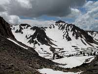
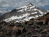
Key Elevation Points: trailhead, 6800’; pass at head of Swift Creek, 10,378'; peak along ridgeline to Corner Peak, 10,940’; saddle between 10,940' peak and Corner Peak, 10,752'; Corner Peak, 11,180’.
You will note that the TH-to-summit elevation difference is closer to 4400’ and not 4600’ as noted above. The 4600’ figure is more accurate because it takes into account the climb up and then down a peak along the ridge between the pass and Corner Peak.
Hike on the Swift Creek Trail for 5 miles to a pass at 10,378'. If you are hiking early in the morning, prepare for your legs to become soaked quickly; you are on a good trail, but waist-high grasses and wildflowers often hug the trail, and you will brush against them. In places, the trail is painfully steep, and you will gain a new level of respect for the backpackers who follow this trail on routes into the heart of the range.
From the pass, hike east and then south for 2 miles to the summit of Corner Peak. The second mile is easy hiking up along a gentle tundra-covered ridge. The route does climb a 10,940' sub-summit of Corner Peak along the way, and that adds some extra elevation gain, but it is nothing serious (see above). It is possible that you could avoid this elevation loss/gain by contouring along the peak's north or south side, but the south side looks pretty rugged and I never saw the north side (I took a variation on this route-- please see below).
Variation
This variation will cut time (maybe), distance (definitely), and elevation gain (also definitely), but it will add difficulty; expect to climb moderate and/or steep snow slopes (unless the snow has melted out, in which case you get to enjoy talus). You will also encounter at least Class 3 scrambling, though Class 4 is more likely.
The route is a little under six miles, and the elevation gain is about 4400'.
Please see the topo map and diagram below.
As you hike up the Swift Creek Trail and study your Crystal Peak quad, you will see an eastern tributary of Swift Creek. You want to more or less follow this tributary into a large, open basin, keeping a prominent rock formation much larger than an outcrop but less than a summit on your left. Head for the ridge between Corner Peak and the pass at the head of Swift Creek, and make sure you aim for a point south (right) of the prominent bump on the ridge (this is the bump that adds the extra elevation gain to the basic route covered above).
You may occasionally encounter waterfalls or small cliff bands on the way up, but they are easily bypassed on some Class 2 or 3 terrain.
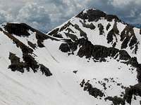
The upper basin may be full of snow, and the slopes will be moderately steep. An ice axe or trekking poles will be useful but probably are not essential; however, you have no way of telling from below how much snow there will be and how hard or soft it will be, so it is better to be prepared. If the snow is gone, you are probably looking at steep, loose talus.
Below the crest of the ridge is the crux of the route-- a long cliff band that is too sheer for scrambling in most places. My climbing partner and I found a Class 4 (arguably low Class 5) break in the cliff band. There might be others, maybe even easier ones, and they may be easier to see if this is your ascent route and not your descent route as it was for us.
Above the cliffs, gain the ridgetop and enjoy the mile or so of pleasant hiking to the summit.
Note-- if this variation is your descent route, a good place to leave the ridge and begin to descend to Swift Creek is at a small area of dark talus (pictured on this page) that stands out as an anomaly on this otherwise gentle and tundra-covered ridge. This is where we left the ridge, and it appeared to be the first and best place to do so; going too much farther risks nullifying the distance this variation cuts, anyway.
Route Topo
