
|
|
Route |
|---|---|
|
|
42.71168°N / 0.34052°E |
|
|
Scrambling |
|
|
Summer, Fall |
|
|
A long day |
|
|
Easy (F) |
|
|
I |
|
|
Overview
A long climb starting from a secluded valley on the spanish Pyrenees, that could be a good summary of this route. Not many spaniards come over here as most climbers sleeping at the local huts go to nearby Bachimala. But it's an enjoyable route with wide open spaces, incredible panoramas when the weather is fine and offering a complete range of terrains, woodland paths, grassy slopes, steep scree and rocky ridges. Deserves a go!Getting There
ROAD ACCESS: For the south face routes, start from Plan (spanish Province of Huesca). From Huesca, take road N240 to Barbastro (49 km). After that, it's road C1311 northwards (9 km) until you find a crossing and follow the signals to El Grado. Turn left there and enter road C138, which will take you after 59 km to Aínsa (via El Grado and puerto de El Pino). There will be only 39 km left then, first by driving northwards on road HU640 (across Labuerda and Escalona) and turning right after Salinas for a final 13 km drive to Plan. This is a rather narrow road, try not to take in the dark and driving will be much more enjoyable (apart from the great views!). After Plan, the final approach to Biadós Hut takes a further 3 km by road and 10 km more of a not too good dirt road. When you reach the final fork of this dirt road, turn right for Biadós and left for Tabernés Hut.A note for big vehicles: If you are driving to Biadós with a big car, a van or a 4-wheel drive (such as a Land Rover or similar) remember that the first two kilometers of the dirt road (after leaving San Juan de Plan) are specially narrow and only allow one vehicle at a time. You might find yourself in trouble and needing to drive backwards if you find someone coming the other way.
BY BUS: Up to this moment, I haven't been able to find any suitable bus connection to Plan. The best I can say for the moment is to catch buses to Ainsa. After that, there are buses going north towards Bielsa but they don’t run every day and I have no information about their possible stops. Therefore, it looks like you will have to arrange some other transport (taxi or whatever) in order to reach Plan and Biadós from Aínsa or Bielsa. I will post any other news on this subject as soon as I get them
NEAREST AIRPORTS: The closest airports are placed in Barcelona (about 300 km away), Zaragoza (about 200 km) and Toulouse. From this last airport you can get to both sides of the mountain (the border can be crossed easily by means of the nearby Tunnel of Bielsa).
RAILWAY ACCESS: The nearest rail stations are the ones at Sabiñánigo and Barbastro. This means that a minimum of eighty kilometers will stand between you and Culfreda from any of them. Additional transport will therefore be required (see "Bus access").
Route Description
 Along the valley
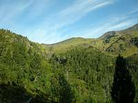 Towards the Puerto de la Madera
 Pic de Cauarère and Culfreda from the Puerto de la Madera
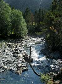
Start walking from the Tabernés hut, at the western end of the dirt road you took shortly after Plan. There’s a wide space close to the hut where you can leave the car. Going downhill towards the river, and slightly to your right as you leave the hut and the dirt road behind you, you will find a bridge closed by an iron gate. Close the gate after crossing it and follow the obvious path along the river, up the valley. You will pass by a small old shepherd’s hut and after about 40 minutes you will get to the grassy plain of Vado de Machimala. There’s a pluviometer on the other side of the river and an easy crossing of the stream to take a route to Bachimala, but our path to Culfreda goes left (west) and is clearly marked by a wooden post. Follow the left path, marked as “Puerto de la Madera”. It goes up winding –at first- through a fir wood and soon gets out of it into wide open prairies south of Culfreda (already seen north of you, to your right). To follow this path is simple enough, it’s well marked (August 2007) by yellow-and-white paint marks all the way up to the border ridge. You will get to the border in about three hours after leaving the Tabernés hut, at a crossing designated on my map as “Port de Cauarère” (according to the same map, the “Puerto de la Madera” promised by the signpost in the valley would be placed some hundreds of meters south of your position, just before the rocky Peña de Millarioux).
But never mind that nomenclature trouble. What’s really important is that –being on the ridge- you have reached the french border. Turn right (north) and follow the border ridge, wide at first and progressively narrowing and getting steeper and steeper. There are cairns marking the path from time to time, but it’s just a question of reaching the Pic de Cauarère (in front of you) and afterwards turning right (east) to descend to a small col. Keep following the cairns even if they lose some altitude towards the spanish face of Culfreda. The path descends a little bit to avoid the ridge (grade II UIAA difficulties) and afterwards gets back to it and keeps going up and up until you reach a fore-summit and –scarcely two minutes after that- the main summit of Culfreda (SW Culfreda). The secondary summits of Central Culfreda and NE Culfreda are placed a little bit farther on the ridge, on good rock. Getting to the last one of them (NE Culfreda) takes about 15 to 20 minutes.
Essential Gear
I'd advice not to try this climb when the mountain is covered by snow or the weather is rainy. The last ridge can be dangerous when slippery by ice, snow or water. Climbing partners not familiar with steep ridges and high cliffs should not try it either. Apart from that, the normal gear for a scrambling or hiking climb: boots, backpack, food, rain clothes (just in case), good boots and hiking poles.Red Tape
There are no special troubles or limitations up to my knowledge. No need for permissions, of course, nor any bureaucratic problems. Be particularly careful to avoid leaving any traces of your stay in the area, nevertheless: the upper valley of Gistain (on the spanish side) is mostly unspoiled and we would all like to keep it like that.Camping and Huts
There are two huts placed on the southern slopes of nearby Bachimala. The Biadós hut is the usual trailhead for Bachimala and the Posets massif, though you can also walk easily west to reach the Tabernés hut and the Culfreda path. It stands at the entrance of the Añes Cruces valley, and is open July to September, during Easter holidays and for the weekends between Easter and July. During all those times there are people guarding it, and offering dinner and breakfast services. Whenever the guards are not there, a smaller space is open for 6 or 7 people.The Tabernés hut is placed west of Biadós, on a small prairie at the beginning of the De la Pez valley. It’s never guarded, just a small house with two rooms. The smaller one has a fireplace and a low table with some primitive seats around it. The bigger room has (August 2007) a big table with ample sitting space and lots of hard (concrete) floor to lay your sleeping bag on. There usually are some old mattresses, but only those arriving to the hut in the first places will enjoy them ;)