Thoughts, Plans And Just Starting Out
An evening on the summit of Sperry Peak (6,140 ft)
My Thoughts;
I'm an extremely busy guy these days. Demanding job, house full of kids, bills, trying to sell my house in a poor economy and just the normal challenges that arise. Being busy with my wife and kids brings me great joy, but the weight of other busy challenges can bring on stress.
I have become creative in finding time to get away from all the busy noise and stepping into the vast stillness, dangereously wild and delicate beauty of the outdoors. Something that puts it all back into perspective. When I say creative, I mean finding a brief gap in the blur of life to step over into the wild.
When you are balancing on the rocks up high, searching for the next good hand hold or securing your footing on steep snow your mind races to its very epical focus. Such a great acute focus, that all the thoughts running through your head are silenced. Your only thought is what your focusing on in that moment. Almost like pushing a natural refresh or reset button.
With that said, it’s amazing how much excitement you can pack into an evening after work.
My Plan;
My friend and I climbed Vesper Peak this winter and I was amazed at how great Sperry Peak looked that day. I just remember it hanging right in there with the big brutes of The Mountain Loop Highway; Sloan and Glacier Peaks.
![Glacier Peak, Sperry Peak and Sloan Peak]() Glacier Peak, Sperry Peak and Sloan Peak Seen From Vesper Peak 2010
Glacier Peak, Sperry Peak and Sloan Peak Seen From Vesper Peak 2010
My plans were to attempt the summit of Sperry Peak afterwork. This is no simple task knowing that it is over 8 miles roundtrip with around 4,000 ft of elevation gain. There would also be river crossings and route finding at the summit block. The bottom line was that I wanted to be back down to Headlee Pass around dark. I knew I had to be on a visible trail and I figured out what my turaround time was. I also had planned to check out the trail to see if it was ok to follow at night. If the trail looked very poor, the lake was going to be my destination for the evening.
I got to the Sunrise Mine Trailhead and headed up the trail around 4:30pm. I know you might think I'm crazy to start so late, but I had everything laid out and knew my turn around time. Its important to give someone details on where you will be and to always be prepared with overnight gear if there happens to be an emergency. I had planned ahead for both.
When I left the trail it was 86 degrees and I was sweating more than normal. You have to understand, thats pretty hot here in Washington State. I knew that I would drink water quickly, so I was glad that I brought my water pump. I made quick work of all the small creek crossings including the larger South Fork of the Stillaguamish River.
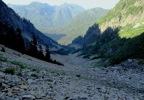
Wirtz Basin And Headlee Pass (4,600 ft)
![Shadows]() Shadows Of The Peaks to Come Looking Into Wirtz Basin
Shadows Of The Peaks to Come Looking Into Wirtz Basin![Wirtz Basin]() Looking Back Into Wirtz Basin
Looking Back Into Wirtz Basin
Soon I was into the Wirtz Basin. It looked much different without snow. It was a sea of Talus. In the winter we went right up the middle, but the summer route stays to the west. I continued up and found the switchbacks going up Headlee Pass. For me, Headlee Pass was harder with snow. Maybe it was because the snow conditions weren't the best that day. Anyhow, I was soon to the top of Headlee. It was nice to go in the evening because I was in the shade through Wirtz and up Headlee. Nice Bonus. Still Hot though!!! I took my pack off for a bit here to spray some bug repellant and have some gummy bears.
![Headlee Pass]() Colors On Headlee Pass
Colors On Headlee Pass![Morning Star Peak]() Morning Star Peak Above And Headlee Pass Below
Morning Star Peak Above And Headlee Pass BelowVesper Lake And Saddle
![Vesper Lake Pano]() View From The South Shore Of Vesper Lake
View From The South Shore Of Vesper Lake ![Vesper Creek Outlet]() Vesper Lake Creek Outlet With The Saddle Above
Vesper Lake Creek Outlet With The Saddle Above
I put on my shades and traversed the talus toward the lake. I was now on the other side of Headlee Pass and in the direct sunlight. Things started to heat up in the late afternoon sun. What a breathtaking area. The Lake below Vesper Peak and Sperry Peak is amazing in the summer. The colors are rich and impressive. I hopped granite boulders and headed to the left (west) side of the lake. Even though I was racing daylight, I took my time to soak in the amazing smells, sounds and beautiful visuals surrounding me.
![Awesome Vesper Peak]() Vesper Peak Seen From The Saddle
Vesper Peak Seen From The Saddle![Vesper Lake]() Vesper Lake Seen From The Saddle
Vesper Lake Seen From The Saddle
I crossed a couple snow fields and started to climb up the North Headwall out of the basin. It was pretty straightforward here. It looked like there are a couple different routes you could take that will get you to the saddle. I quickly got to the saddle that connects Vesper Peak and Sperry Peak. The views from the saddle are outstanding.
![Vertical Pano Of Big Four Mtn]() Vertical Pano Of Big Four Mountain From The Saddle
Vertical Pano Of Big Four Mountain From The Saddle
I was very impressed looking at the ridge that connects Vesper Peak and Big Four Mountain. Somebody slap your momma!!! That Granite is so sweet looking, and the Glacier below was also incredible. I headed up the ridge on a faint trail through steep heather.
![Connecting Ridge]() The Awesome Granite Ridge Between Vesper Peak And Big Four Mountain
The Awesome Granite Ridge Between Vesper Peak And Big Four MountainSummit Time
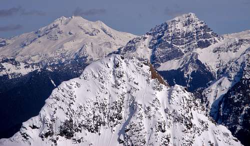
![Sperry Peak Summit Pano]() Summit Pano Looking West
Summit Pano Looking West![180 Deg Summit Pano]() 180deg Summit Pano Looking North, East and South
180deg Summit Pano Looking North, East and South
Of course it only took a couple minutes before I was off trail and bushwhacking. I wasted a lot of time and finally connected with the trail again at a talus/snow field. I lucked out with some cairns that helped me navigate the talus field. If all else fails you can just go up. I just wanted to make sure I dove into the mountain hemlocks at the right spot. I did. For a bit. I was soon side traversing South on a shortcut trail and found myself on solid class 3. It’s frustrating because the class 3 route is flagged with pink ribbon. It was spicy to say the least, but I didn't have all day to be hanging over cliffs with handfuls of heather. At one point there was a gnarly move on slippery pine needles, but I could see the pink ribbon ahead up the gully. I went for it and after a couple boulders I was at the base of the false southern summit. I had traversed to far south, but still punched out close enough. I climbed the false summit, which is very small and exposed. I dropped my camera into the summit rock, but I was lucky enough to reach it with my ice axe.
![Glacier and Sloan Peaks]() Glacier And Sloan Peaks
Glacier And Sloan Peaks![Del Campo North Face]() Del Campo Peak's Impressive North Face
Del Campo Peak's Impressive North Face
I could tell that I was about 10 feet below the true summit, so I dropped down and climbed over to the true summit. It was larger with much more room. I didn't see a summit register, but I did see an amazing sunset going off. I took about a 10 minute break to soak in all the goodness. What a great mountain. After that entire route finding drama it was about 8pm. The sun was a ball of fire and just a touch above the horizon. Enough time for me to get down to the lake on safer ground.
![Del Campo, Morning Star and Gothic Peaks]() Del Campo, Morning Star and Gothic Peaks
Del Campo, Morning Star and Gothic Peaks ![Vesper Lake]() Looking Over At Vesper Peak And Down Below Is Vesper Lake
Looking Over At Vesper Peak And Down Below Is Vesper LakeHeading Down With The Sun
Going down I tried the north rocky ridge. I found a couple cairns and more ribbon, but this way looked a lot less technical. I followed that route down and only experienced class 2. There was still one section that was physically hard, but not exposed. I dunked my hat in every little pool of water I came across. She was a hot one folks. On the way down I experienced some of the most amazing colors I have seen in a long time.
![Vesper and Big Four]() Vesper Peak To Big Four Mountain Pano
Vesper Peak To Big Four Mountain Pano![Sun Hiding]() Hiding Sun Out West
Hiding Sun Out West![Evening Snow Field]() Evening Snow Field On Sperry Peak
Evening Snow Field On Sperry Peak![Big Four Mountain]() Backside Of Big Four Mountain At Dusk
Backside Of Big Four Mountain At Dusk![Sundown]() Layers At Sundown
Layers At Sundown
I made quick time coming down. Finding the trail made the descent a lot quicker. I ran into a fellow hiker and member of NWhikers Chief Joseph. I had read his trip reports before and it was nice to meet him down at the lake. I told him that I was jealous and wished I was also camping at the lake. He really had a great setup, I was sad to head home because it was such a beautiful evening. I made the chat quick because I still had almost 3 miles to go on some extreme terrain.
I pumped water out of the creek and ate a couple oatmeal cookies I bought at the Chevron in Granite Falls. The lady at the Chevron said they were the cheapest oatmeal cookies in town. I told her that I would be back for sure.
I headed down Headlee Pass in the dark. As you can imagine how great that was. I just went slow and careful. It actually seemed easier to see the trail at night. I was surprised. What was kind of sweet is that the cairns stood out at night with a headlamp. I would shine it ahead every so often through Wirtz Basin and see the next objective.
The Fall And Limping Home
I didn't start going fast until I was at the bottom of Wirtz Basin. This is where I took a fall. It was my first time out this year with trail runners. I started jogging a bit because I was getting bored and thought I could make up some time. I stepped down on a loose rock with my left foot and lots of momentum. All I could feel is a couple large snaps and down I went. I lost all control and landed on my right knee. There I laid on the trail. Just a big heaping pile of sweaty mess. I became really dizzy and I could feel adrenaline kick in. I sat up and tried to breath calmly to settle myself down. I drank some water and didn't move quickly. I was scared that my ankle was bad. I slowly got up to see if I could put weight on the foot and I could. I was not sure at the time if the adrenaline was taking away the pain, so I didn't want to make it worse. I needed to continue, but I could not risk rolling it again since it was very weak. The challenge was set before me. I needed to get down the next mile and cross the Stilly in the dark. My ankle felt real tender, but I knew it was possible. I put my trekking pole in my left hand and ice axe in my right. I descended slowly, but with careful confidence... and also a sense of frustration. Why did I where the stupid trail runners? Why did I need to start jogging? I continued on, trying to keep my mind off the pain and more on complaining. I was going snail pace and the moths started to hover around my headlamp like I was a street light in the slums of Darrington.
Soon I got to the river crossing. It wasn't that bad. One slip on the wet rocks and I was for sure going to role my ankle again, but I didn't let it happen. This isn’t my first river crossing... well my first with a rolled ankle and banged up knee. I started to cramp up in the legs because I was using weird muscles to keep the pressure off my ankle.
Wow that was a lot of drama. I made it to my truck, put on my flip flops and headed home. I texted the wife so she could get some ice ready for me when I got there. I can't say she was thrilled about the whole shindig, but she loves me and was happy that I made it home safe"ish". Well in my books I was in one piece and had a story to tell. Showed up at work the next day bright eyed, bushy tailed with a bit of a gangster limp...
Even with the fall, I was so glad that I got to experience such an amazing and beautiful evening in the mountains.


Comments
Post a Comment