A few days to spare
The Geigenkamm ridge runs north-south, squeezed between the long Pitztal and Ötztal valleys. Hiking and climbing the full length of it would take the better part of a week, and even that would only be possible if you more or less follow the established hiking and climbing routes, which do not exactly follow the crest. In contrast, hiking across the ridge from east to west or vice versa is possible in several places and can even be done in a long day.
But why hurry? It's a beautiful area, and there is plenty to do. Hiking opportunities abound, there are climbing routes and there is even the odd Via Ferrata. There are even a few small glaciers. And you don't have to bring camping gear or much food, since there are plenty of mountain huts where you can sleep and get a good meal.
I had just visited the tri-country area around Liechtenstein, Switzerland and Austria, and had five days before I would meet a group of other climbers in Sölden, in the Ötztal valley to the east. I studied my maps and my guidebook, and made my plans. It would be mostly hiking; being alone, I would have to hold back a bit.
Itinerary
Day 1: Starting at the small hamlet of Trenkwald (1501m) in the Pitztal, I hiked up a steep trail heading east. It started innocent enough in the dense forest low down in the valley, but as I got higher, I had to cross a couple of steep snow fields that totally covered the trail. Once above the tree line, the terrain was less steep. I turned towards the south now, and made my way over the Kapuzinerjoch (2710m) (joch = saddle) and Gahwinden (2649m) to the
Rüsselsheimer Hütte (2323m).
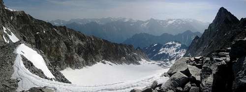
![Panoramic view east over the Innere Pirchkar glacier, from just south of Hohe Geige]() Panoramic view towards the east, over the Innere Pirchkar glacier, from just south of the Hohe Geige
Panoramic view towards the east, over the Innere Pirchkar glacier, from just south of the Hohe Geige: On a daytrip from the refuge, I hiked and scrambled my way up the west ridge to the summit of Hohe Geige (3395m), the highest peak on the Geigenkamm. For the sake of variety, I went down along the normal route. Frankly, the west ridge was easier and safer, even if it was more exposed and required a few climbing moves. The normal route had some loose stuff on the trail, but what really made it dangerous was the couple of steep snow fields covering the trail.
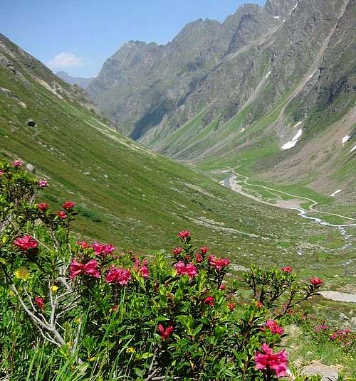
![Alpine rose in the Pollental]() Looking down the Pollestal valley
Looking down the Pollestal valley![Alpine Crowfoot (Ranunculus glacialis), at the WeiÃmaurachjoch (2953m)]()
Alpine Crowfoot at the Weißmaurachjoch
: Today I could have used a rope and a partner, because then I could have followed the "Mainzer Höhenweg", which, from what I've read and heard, is one of the finest alpine routes in the area, including easy climbing sections and short glacier crossings. The complete route is quite long, and there is a bivouac shelter a little over half way (when following the ridge N-S, that is) for those running out of time, but it was early summer, so there would be plenty of daylight.
I started the same way by hiking up the just over 600m from the refuge to the Weißmaurarchjoch (2953m), but while the Mainzer Höhenweg turns south from there (and continues up), I descended on the other side, down into the Pollestal, and only turned south after reaching the valley floor (around 2200m). The plan was to hike up the length of the valley, and get back on the Mainzer Höhenweg past most of the problems. And in fact that worked out well, with one notable observation: this detour, while easier, was very long as well, much longer than I had expected!
I reached the high route at the Nördliches Pollesjoch (2937m) and followed the ridge from there. Eventually I got close to running out of daylight, but, after some ups and downs along the ridge, arrived at my destination, the
Braunschweiger Hütte (2758m), just after sunset, tired and hungry. Fortunately, the weather held up just fine, with the sun shining brightly all day.
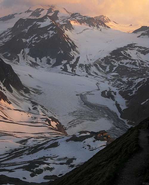
![Wildspitze (3768m) dwarfing the Braunschweiger Hütte]() I'm going to arrive around sunset at the Braunschweiger Hütte, dwarfed here by the Wildspitze (3768m)
I'm going to arrive around sunset at the Braunschweiger Hütte, dwarfed here by the Wildspitze (3768m).
Day 4: According to the latest forecast, the spell of good weather was about to come to an end, and the day after tomorrow would bring rain. So, I changed plans, and would just descend from the Braunschweiger Hütte down to Sölden (1368m). Well, there would be a small bit up, because my chosen route would lead me over the Rettenbachjoch (2990m). That high saddle is right at the edge of the former summer ski area. Thanks to that past development, there is a good road nearby, including a bus connection. However, having enjoyed a good night's rest and excellent food at the refuge, I had enough energy to do a bit more than catch a bus, or even simply hike down today.
Looking at my map, my eye fell on the hiking trails up to the Schwarzkogel (3016m) and Rotkogel (2947m). First I would have to hike down the valley to about 2500m or so, but compared to hiking straight down to Sölden, the advantage was that I would only have to follow the road for a short while, and I could make my way up a few more montains.
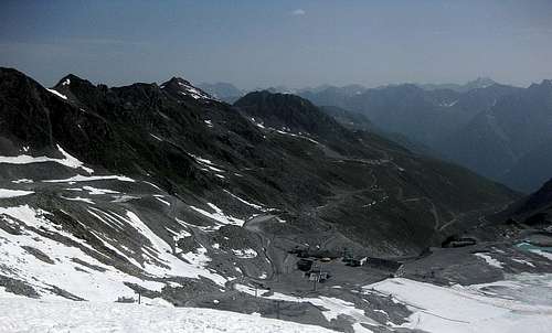
![Looking down the Rettenbachferner]() The Schwarzkogel (3016m), just left of center, seen from below the Rettenbachjoch
The Schwarzkogel (3016m), just left of center, seen from below the RettenbachjochThe trails proved easy, and, very convenient, at the base of the east ridge of the Rotkogel was a restaurant, the Rotkogeljochhütte (2660m). In summer it's not a crowded place, but in winter it must be a different matter: this area is part of the winter ski arena.
On my first pass, I stopped only for a few minutes, just long enough to leave my backpack in a safe spot, and then I was on my way again.
![Rotkogel (2947m) from the banks of the Schwarzsee]() Rotkogel from the banks of the Schwarzsee
Rotkogel from the banks of the SchwarzseeAfter climbing Schwarzkogel, I had a hearty meal - then I made my way up the Rotkogel and had another big one. I might have made a bit of an impression, doing that...
Day 5: As predicted, it rained, pretty much all day, so I took it easy. I only went out for food - a man's gotta eat, right?
Comments
No comments posted yet.