
-
 13888 Hits
-
 85.36% Score
-
 20 Votes
|
|
Mountain/Rock |
|---|---|
|
|
48.39421°N / 114.57697°W |
|
|
Flathead |
|
|
Spring, Summer, Fall |
|
|
5325 ft / 1623 m |
|
|
Overview
Layout designed for best viewing on a "1024 x 768" screen.
 Tally Lake
A tally is an account or reckoning; a record of debit and credit, of the score of a game, or the like.
Tally Mountain is found in the Salish Range and sits by Montana's deepest lake.
"This mountain will let you absorb the natural beauty of the surrounding vicinity"
Tally Lake is a clear, scenic, low elevation mountain lake. The Lake is at 1350 acres in size and with a depth of 492 feet.
Although it isn't a huge lake, Tally Lake has the distinction of being the deepest natural lake in Montana.
Lying in the heavily forested, lower mountains to the west of Whitefish, Tally Lake offers less than spectacular fishing in a very nice environment. Tally Lake is home to a fair number of small rainbow trout, cutthroat trout, whitefish and brook trout.
Virtually all of the use on Tally Lake comes in the form of recreational boating of one variety or another. The lake's large size and clear water, along with its close proximity to the Flathead Valley, make it a popular place for boating and waterskiing. Additionally, a large campground and day use area at the head of the lake is a popular place for camping, picnicking and parties.
Getting There

|  |
|---|
To find Tally Mountain's trailhead, start from Downtown Whitefish and drive 5 miles on U.S. 93 North to Twin Bridges Road and turn left.
Next, drive approximately 1-2 miles and turn right onto Twin Bridges Road (Yes it's Twin Bridges Road again)
Then, turn left on Farm to Market Road. You will see signs for Tally Lake Campground. Go 2 miles and turn right onto Tally Lake Road, which is not paved.
It is approximately 6 miles to the pullout by Tally Mountain's trailhead.
Red Tape
Tally Mountain is located in the Salish RangeThis is bear country. So hike with bear spray and make lots of noise.
Motorized vehicles are allowed on all of Trail 800 and on a large portion of the route from Reid Divide to just south of Tally Mountain.
Route Information

|

|
|---|
 Lodgepole Pines surround the summit
The Tally Lake Trail is a stunning hike through large old larch, Douglas fir, spruce and ponderosa pine which conceal Tally Mountain. The hike is a nice exercise that almost reaches 2,250 feet in elevation gain. It's a great hike to do on overcast or rainy days as the heavy tree cover keeps hikers relatively dry.
Hike up the trail as it will gradually lead up the flanks of Tally Mountain through an astonishing variety of forest types. Once you hike 2 and a half miles, the trail intersects with the Tally Gorge Trail (#294), but stay on #800 and follow it for approximately a quarter of a mile. At a convenient place of your choosing take a short bushwack uphill to the left of the trail to the tree-covered summit of Tally Mountain. You can take trail #800 south for several miles to just east of Ashley Mountain, which is several miles northwest of Kalispell.

|  |
|---|
Weather
Camping and Essential Gear
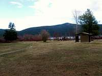 Tally Lake Campground
The closest campground is to the north called Tally Lake Campground. Tally Lake Campground is right next to the lake; Logan Creek empties into the lake next to the campground.
Tally Lake Campground in Montana is the outdoors at its finest.
Any time is a good time at Tally Lake Campground if you love the outdoors.
Bring water and bear spray.