
|
|
Route |
|---|---|
|
|
46.39000°N / 13.59000°E |
|
|
Scramble on an easy feratta |
|
|
A long day |
|
|
Walk up and secured climbing |
|
|
Approach
Starting point of this route is Tamar hut, which lies in Tamar valley. Tamar valley is actually upper part of Planica valley, which is farthest to the west of all Julian Alps valleys, which are perpendicular on Upper Sava River valley. Planica is best known for ski jumping & flying. World distance records have been set here. Valley is closed on the south by massive walls of Mojstrovka, Travnik & Sit ridge. On its beginning lies the village of Ratece.
Tamar hut (1108m) stands on the edge of a meadow from which is beautiful view on the towering peaks around, especially Jalovec. This is one of the most romantic spots in Julian Alps. It was opened in 1899. It has 128 beds and its open all year round. Tamar hut is accessible by car from Ratece (6km).
Route Description
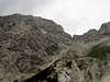
From the Tamar hut path gradually ascends through the forest till it reaches huge scree slopes at the end of the valley. Cliffs on both sides of the valley are getting closer and valley gets steeper all the time, turning it almost into gorge.
Over the scree and snow fields path reaches the bottom of Jalovec cliffs.
You follow that path when the path leaves last greenery and begins to ascent scree slope bellow Jalovec. From here you can notice steep climbing shelf in the cliffs on the right. At the altitude around 1550m path turns right going far right using this shelf. When it ends path turns left climbing steeply till it reaches large rocky plateau bellow Kotovo Sedlo pass. Path gradually ascends, going around huge boulders, to the pass (2134m).
Now you descend around 200 metres and when you see the signposts for Mangart and for Rob nad Zagacami you turn right and soon you become ascending. Some parts of the route you must climb but they are all secured.
Now you come to the next crossing when you follow the signposts for Rob nad Zagacami (you turn right) and soon you come to the Bivouac on the Rob nad Zagacami. Here comes the ferrata Via della Vita from Italian side too. You follow the signpost over south face and slopes of V Koncu spica and soon you come to the top of Vevnica.
You descend by the same route.
 |
Essential Gear
Good hiking shoes, helmet, rope.
Miscellaneous Info
If you have information about this route that doesn't pertain to any of the other sections, please add it here.