
|
|
Mountain/Rock |
|---|---|
|
|
44.72242°N / 111.38829°W |
|
|
Fremont |
|
|
Hiking, Scrambling |
|
|
Summer, Fall |
|
|
10300 ft / 3139 m |
|
|
Overview
 The south side of Targhee Peak after a storm
 North side of Targhee
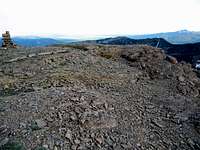 The summit of Targhee
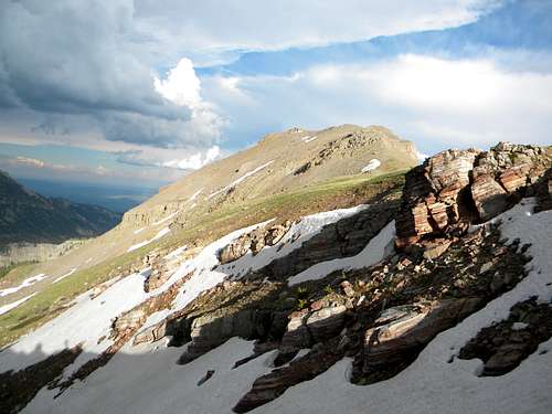
 Bacon rocks
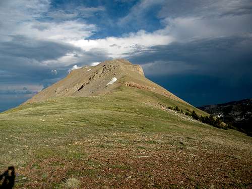
 South side of Targhee
 Nearing the summit and sunset
 Camp at Targhee Pass
 Alpine forget-me-not
 Northwest aspect
Targhee Peak is the high point of a ridge spur into the Idaho side of the Continental Divide within the Henry’s Lake Mountains a few miles west of Yellowstone National Park. It is the third highest peak within these mountains at 10,300 feet. It splits the two large forks of Targhee Creek, which is the main basin draining much of the central and south portion of the mountains south to the upper Snake River. It has 300 feet of prominence.
The mountain takes the general form of a battleship that is perched on the divide between two large canyons. It rises 1,300 feet above the broad north basin; 2,300 feet above the incised West Fork of Targhee basin to the southeast and nearly 3,000 feet above the confluence of the two streams at its east base. The ridge runs rough east-west and is perpendicular to the main Continental Divide to the west and supports three main large ridge outcrops along with some smaller ones; the easternmost being the highest. These look formidable from some angles, but are easily navigated along the main ridgeline that is in reality little interrupted. The north and south slopes are scree dominated and difficult to maneuver. There are no trees or brush from a little below 10,000 feet and the mountain supports some good examples of true climatic alpine vegetation. The interesting summit is fairly broad and appears to be crumbling from within. There are what appears to be a few sinkhole-like features where the smaller surface rocks are settling into large gaps forming in the base rock within the mountain. In general the mountain appears to be quite crumbly, but a good firm goat path exists along the summit from Targhee Pass, just to the west.
This mountain can be done in a long day hike by a strong hiker. The path would be on a good trail for about eight miles to Targhee Pass, then about a half mile of easy, off-trail hiking to the summit. From the trailhead it is about a seventeen mile round trip to the summit and back. It might be best to camp or make it an extended hike and spend some time on the other summits or several lakes found in this small, but interesting mountain group. This is a grizzly bear area so take pepper spray, make noise, have a clean camp and take some friends who you can outrun.
Getting There
 Continental Divde, Targhee Pass and Targhee Peak
The area can be entered via the Mile Creek Trail (004) from the Montana side or from the Targhee Creek Trail (27) on the Idaho side. The Targhee National Forest does a great job of providing access and trail info from the Idaho side on the internet, but the Beaverhead NF does a terrible job for the Montana side. Fortunately the best way from the Montana side is provided for you here.
Mile Creek Trail
 Mile Creek Trailhead
 Targhee Pass
 Junction 04/27 trails
If coming on Highway 20 from the south, drive 42 miles north from Ashton to the junction with Highway 87. Turn left (west) on Highway 87 drive nine miles to the Idaho/Montana State line. Continue north on the same highway for approximately 3.6 more miles to the Mile Creek Road. This is marked by a small roadside sign that looks like its pointing into the driveway of a large house close to the highway. Take it and the road will almost immediately turn away from the house and head for the mountains. From the turnoff from Highway 87, its one mile to the trailhead. There is a stream to cross immediately before the trailhead, but the bottom is a hardened crossing so it should be no problem for most vehicles. If unsure there is room to park west of the creek and cross on foot. The total distance from Highway 20 to the trailhead is almost 14 miles.
To reach the trailhead from the north take Highway 287 south from Ennis, Montana for 40 miles, then turn right (south) on Highway 87 and go five miles south to the Mile Creek turnoff by the large house mentioned above. If coming from the east, go 13 miles from West Yellowstone over Targhee Pass to the junction of Highway 20/87 mentioned above. Follow the directions from there.
The Mile Creek Trail is not as indicated on USGS quad maps. The first two or three miles is the same, but new construction takes the trail on a series of long switchbacks and reaches the top of the Continental Divide further south than indicated on the quad maps. The trail is obvious and there is no way to get lost on the old trail. From the trailhead follow the path south up the Mile Creek basin for approximately six miles to the junction with the Targhee Creek Trail (27) on the Continental divide separating the Targhee Creek and Mile Creek basins. From here make a left turn go approximately two miles to Targhee Pass. The mountain is the high point to the east of the pass.
Targhee Creek Trail
To reach the Targhee Creek Trailhead go 15 miles north of the Island Park Ranger Station on Highway 20 to Forest Road 57 and follow it a short distance where it ends at the trailhead. The turnoff for road 57 is about 10 miles west of West Yellowstone. The Targhee Creek Trail with a 1.5 miles portion of the Continental Divide trail makes a 15 mile loop through the heart of the Henry’s Lake Mountains. To reach Targhee Peak from this trailhead, there are two options. Basically take either branch of the loop trail and follow it to where they meet at Targhee Pass. The west side of the loop is a little shorter, but the right may be a bit more scenic. It’s approximately six miles to the basin at the northeast foot of Black Mountain up the west fork.
Route Overview
 Targhee Pass
Once at Targhee Pass the easiest way by far is to simply follow the ridge line out to the summit. From the south the outcrops look like they could provide some barriers, but from the north the ridge is seen to be fairly gentle. There is one outcrop near the lower west end that must be navigated, however. It is far better to go around this on a short scree section on the south side. It is possible to go around it on the north side on generally firmer footing, but the apparently more solid rocks could come loose and there is some exposure here. Once around the lower western outcrop there is a more or less obvious goat trail along the ridge to the high point. The scree on the south slope is difficult and except for the short go around of the outcrop mentioned, it should be avoided.
 Nearing the summit
Red Tape
Generally none. The area is not designated wilderness, though it is largely managed as such. In the core travel areas travel is limited to hikers and horses. Other areas allow bikes, but all areas are non-motorized. The Targhee National Forest provides an excellent travel planning map online for access from the Idaho side. It is assumed management for the Montana side is similar, but that information is not as readily available. If it matters use the Beaverhead-Deer Lodge contact information provided below.Camping
 Camp at Targhee Pass
 Nearby lakes
 Targhee Pass spring
Camping is somewhat limited close to Targhee Peak. The best option would at Targhee Pass, which sits at 10,000 feet between the main Continental Divide and the summit. There is plenty of water early in the summer and a large spring on the south brim of the pass may run late into the summer or even all year. But if this is not available there would be no water nearby once it dries up. The flats at the northeast foot of Black Mountain likely have good water and offer extensive camping locations, but this area is at least two miles south of Targhee Pass. The broad basin at the north foot of Targhee is also an option with a stream that should provide water all year
When to Climb
The snow is still heavy well into June most years, but by the start of July enough of the trails and slopes are open to provide good access. The north slopes may hold their snow well into summer however. The south slope loses its snow quite early in the summer, but getting to the mountain would be difficult due to snow on the forested sections of the approach. The mountain can be reached in winter by the hard core, but all slopes would be prone to avalanches and access would be long, difficult and dangerous.Mountain Conditions and Information
 North side of Targhee Pass
Go to the mountain prepared for variable conditions. A summer a day that starts out nice and clear often will see thunderstorms move into the mountains bringing rain, cold and lightning. Check the forecast closely and be prepared.
For specific information contact the Island Park Ranger District of the Targhee National Forest.
An access map on this Forest’s web page makes planning easy.
Island Park Ranger District
Targhee National Forest
3726 Highway 20
Island Park, Idaho 83429
(208) 558-7301
For the Montana side this area is part of the Madison Ranger District of the Beaverhead-Deer Lodge National Forest.
Madison Ranger Station
5 Forest Service Road
Ennis, MT 59729
Phone: (406) 682-4253
>NOAA Forecast
 Last rays of the day