PROLOGUE DIALOGUE
Good Buddy: "Does the weather forecast for Sunday look decent?"
Me: "Ten-Four, good buddy!"
Good Buddy: "Is the snow at least 3-4' deep above 3000' elevation?"
Me: "Ten-Four, good buddy!"
Good Buddy: "Is the Forest Road 62 gate open?"
Me: "Ten-Four, good buddy!"
Good Buddy: "Is it possible to drive all the way up to the Forest Road 6221 gate?"
Me: "Ten-Four, good buddy!"
Good Buddy: "So where are you planning to go on Sunday?"
Me: "Ten-Four, good buddy!"
PREAMBLE
![Ten-Four Mountain]() Ten-Four Mountain
Ten-Four Mountain
Of Washington peaks with over 2000' of prominence (P2K),
Ten-Four Mountain is the nearest to my childhood home/hometown of Gold Bar, Washington. The peak is located only 3.5 miles south of the city. Although I was raised in Gold Bar, I did not become interested with a possible Ten-Four Mountain ascent until many years later.
In July 2008 I summited nearby Haystack Mountain, before prominence mattered much to me. The weather that day was decent to the north but shrouded with clouds to the south. I noticed the Northeast Ridge of Ten-Four Mountain and wondered how plausible that ridge traverse would be. Knowing the potential for nasty brush and blowdown areas in that general region, I speculated a snowy ascent via that ridgeline might be the best option for Ten-Four Mountain.
As I became more interested in prominence during the next few years, Ten-Four Mountain was near the top of my peakbagging goals. Nearly all, if not all, summit attempts of Ten-Four Mountain are done by peakbaggers interested in prominence. After all, the peak is below 4400' elevation, has a forested summit, is located in a relatively obscure area, and is notorious for having thick undergrowth. The mountain had been summited by multiple people from multiple approaches, each with their advantages and disadvantages. But with Ten-Four Mountain being what I considered my hometown P2K peak, I did not want to cheapen the ascent by choosing any routes and conditions other than those I really aspired to try on my own.
I wanted to summit the peak with the parameters I determined might be most desirable: deep snowpack, decent weather, and the ability to drive to the gated entrance of Forest Road 6221 located several miles east of the mountain. I speculated I would have the best chance for a successful summit attempt, least chance of brush and blowdown problems, and most opportunity for enjoying the trip by following those parameters. I stop short of suggesting that I wanted everything to be perfect, as I know nothing can be perfect. Plus, there were definitely some unknowns about the route approach I had planned. So I waited patiently....
In early November 2010, the feasibility of my route idea caught its first major break. Ken Russell, a local peakbagging friend, had just summited Ten-Four Mountain, coincidentally via the route I had already been considering. The big difference between his trip and my route idea was that he had traversed the terrain during a day with no snowpack... so he had the most possible brush and blowdown to deal with. He made multiple comments about how thick, nasty, and annoying the underbrush was during his trip. In contrast, my plan was to basically follow the same ridges as Ken, but with a minimum of 3-4' deep snow to ease a snowshoe traverse.
Decent weather was forecasted for Sunday, April 3, 2011, and I had no lingering plans for that date. Already knowing at least 3-4' of snow depth would be on the upper sections of the ridges (thanks to data supplied by the "Alpine Meadows" SNOTEL site located southeast of the peak), I contacted Ken for possible route beta. He told me the ridge approach might actually be better with snowpack because all of the potential troublesome brush, tree blowdowns, and young alders (on old logging roads) he had encountered during his November trip would now be covered-over by snow.
He also mentioned one possible crux section: Point 3816, near the northern end of the Northeast Ridge of Ten-Four Mountain. Point 3816 is a hill comprised of massive boulder-blocks, which required Ken to do some light scrambling when no snow was present. There was a chance the deep snowpack might make the boulder hilltop more easily passable or possibly impassable. Not knowing how snow would effect that specific route section but still willing to take a chance, I set off for the snowy approach as planned.
APRIL 3, 2011: THE TREK TO TEN-FOUR
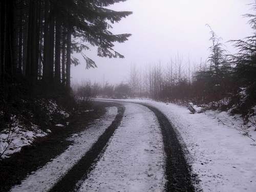
Parking at the entrance gate for Forest Road 6221, I departed on my quest at 6:00 AM. With virtually no snow encountered on the road, I made great time. I reached the Duffey Creek bridge crossing within one hour. Suddenly, the snow on the road changed from only a trace to 2' deep. But with the cool temperatures and a crusty top layer I was able to continue further for a while without the use of snowshoes. Eventually, post-holing became more prevalent and I had to put on snowshoes at ~2500' elevation. It was near this time that I noticed hundreds of black worms crawling along the snow in shaded areas. Looking back at several of my post-holed footprints, I could see the black-colored worms in the middle of the snow layers there, as well.
![Ten-Four Mountain]() Heading East Along Forest Road 6221...
Heading East Along Forest Road 6221...![Snow Worm]() Looking At Worm Crawling On Snow...
Looking At Worm Crawling On Snow...
The logging road progressively appeared less used as I continued. By the time I reached 3000' elevation, young alders became abundant along the old road. With snow and snowshoes these sections were no problem to traverse around. With no snow I can speculate these sections would be at least a minor annoyance. I easily reached the road-end (~3400' elevation) at the northern end of the Northeast Ridge. Looking at my map shortly beforehand, I had an option to take an alternate road that side-traverses along the western slopes of the ridge an ends at a higher elevation, but those slopes appeared to be much steeper than anything I would need to encounter via my intended route.
![Ten-Four Mountain - NE Ridge]() Looking Up At Northeast Ridge
Looking Up At Northeast Ridge![Ten-Four Mountain]() Following Snow-Covered Logging Road...
Following Snow-Covered Logging Road...
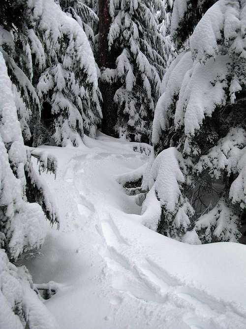
I left the road and began ascending up the forested slope NNE of Point 3816. The young evergreen trees were semi-thick for several hundred feet elevation, but no problem to traverse around in the snow. By ~3600' elevation the forested ridge seemed to open-up with a lot of second-growth and third-growth evergreens. I found few outward views from this section of the ridge, but I really enjoyed the forested snowshoe traverse.
![Ten-Four Mountain]() My Path Through Thick Evergreen Forest...
My Path Through Thick Evergreen Forest...![Ten-Four Mountain]() Ascending The Northeast Ridge...
Ascending The Northeast Ridge...
At ~3780' elevation I first noticed a large boulder sticking out from the snow. Looking up ahead, I could see a series of massive block-like boulders comprising the top of Point 3816. Both the west and east slopes of the hill were steep and cliffy. I either had to backtrack and drop down several hundred feet to possibly bypass this section, or scramble down a steep crack opening between boulders from near the top of the hill, or continue traversing between boulders over the top of the hill.
![Ten-Four Mountain - Point 3816]() Boulder "Crux" Section At Point 3816
Boulder "Crux" Section At Point 3816
I preferred the latter option as my first choice because it appeared to be the easiest and quickest option. I took out my ice axe. With my snowshoes still on, I found what turned out to be a snowy path between two massive boulders. I carefully probed the intended route, trying to make certain there were no large rock cracks I could fall through. The size of the snowshoes may have actually assisted that effort. Once I scurried around the top boulders, a short (15'-20') steep snowy slope awaited me on the south side of the hilltop. This slope seemed a little icy underneath the top snow layer, so I wondered if I would need to carefully climb up it with my microspikes (rather than snowshoes) on the return-trip.
![Ten-Four Mountain - East Ridge]() Looking Ahead To The East Ridge...
Looking Ahead To The East Ridge...
The remainder of the Northeast Ridge traverse was narrow in many places but otherwise uneventful. With that said, this ridge traverse starting from the old logging road took me longer than I had initially expected, mostly because of the route unknowns, using extra caution, and snow trailbreaking. When I reached the cliffy north side of Point 4228, I opted to avoid the cliffs by side-traversing southwest at ~4000' elevation. The slopes during this section are steep, but with deep snow were easy to traverse this day. This was the only section along the route where I would be even partially concerned about avalanche danger, but I used caution and the conditions were favorable. With less snowpack, crampons and/or microspikes would probably be advised for this side-traverse. With no snowpack, veggie ("green") belays would probably be needed.
![Ten-Four Mountain Side-Traverse]() Side-Traverse Path Below Point 4228
Side-Traverse Path Below Point 4228
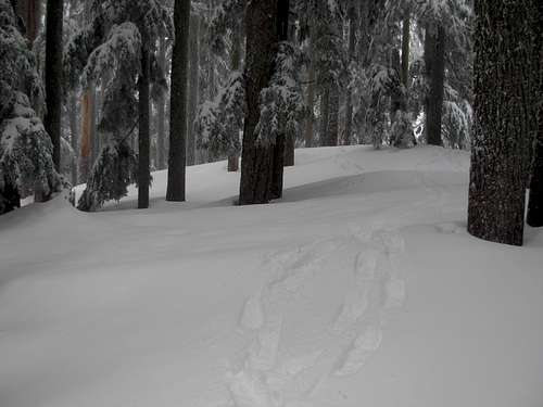
I reached the top of the East Ridge of Ten-Four Mountain without incident. After initially contouring around a minor rocky hill when I got onto the ridgetop, I headed west towards the summit. This ridge was the easiest part of the entire route; a straightforward westward snowshoe traverse. All brush and blowdown sections along this ridgetop were completely covered-over and I reached the summit after being on the East Ridge for less than 30 minutes.
![Ten-Four Mountain]() Easy Traverse Along East Ridge
Easy Traverse Along East Ridge
I reached what appeared to be the summit at 10:45 AM. If I had not taken some elongated breaks for nonsensical reasons, I could have been at the summit by 10:00 AM. I kept hoping the sun would come out and the low clouds would lift, but neither happened. The summit trees had the appearance and description of those I had known about, and my GPS showed I was at the correct location of the summit. However, just in case I might be on a false summit with the true summit hidden by thick forest nearby (which happened to me a few weeks prior on another peak), I continued down the west side of the summit slope just to ensure I had indeed reached the correct spot as indicated. I was getting noticeably further from the summit hill and my GPS confirmed the assertion, so I headed back to what I believed to be the summit.
![Ten-Four Mountain - Summit Area]() My Paths Around The Summit Area...
My Paths Around The Summit Area...
I did not find the Dean Molen salsa register or semi-mythical Paul Klenke film register at the summit trees... probably because the snow depth at the summit was at least 4-5' deep. I did not feel like digging down several feet in snow with the hopes of finding a register which may or may not even be there. I did not do it at Gannett Peak two years ago and I was not going to do it on Ten-Four Mountain, hometown P2K or not.
![At Ten-Four Summit]() Success!!!
Success!!!
After spending 30 minutes at or around the summit area, drinking Gatorade and exploring every possible bump nearby, I decided it was time to go. I briefly considered descending north down a snow-covered stream gully, but I had already seen several steep sections within the gully from atop the Northeast Ridge. Plus, being solo, I did not want to deviate from an already-successful and known approach.
The "crux" section at Point 3816 was much easier than I expected it to be on the return-trip. In fact, with my path already in-place the entire descent was smooth and quick. I took three 15-minute breaks along the ridgetops, mostly to wait for the clouds to lift (they kept teasing me!) so I could get a good photos of Ten-Four Mountain or the surrounding areas. Alas, it was not to be on this day.
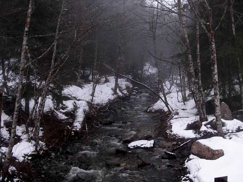
With my snowy trail already in-place, my descent was fairly swift. I kept my snowshoes on until after the Duffey Creek bridge. I was back at the car by 2:30 PM. Not including breaks, my actual moving pace for this trip was 4h0m up, 2h30m down (6h30m total). Including breaks, my overall trip time was 8h30m. Wow, this trip had a lot of nonsensical breaks; none of them were even rest breaks.
![Duffey Creek]() Duffey Creek
Duffey CreekFINAL TRIP STATISTICS AND GEAR USED
![Ten-Four Mountain - East Ridge]() Route Of My Ten-Four Mountain Trip
Route Of My Ten-Four Mountain Trip
-> Approximately 12 miles roundtrip. Only 1.5 miles each way was off-road, and that was completely on the Northeast Ridge and East Ridge sections.
-> Approximately 3300'-3400' of cumulative elevation gain.
-> Approximately 8h30m overall, but again that was due to me wasting a lot of time along the way.
GEAR USED:
-> Snowshoes
-> Ice axe
-> One trekking pole
-> Microspikes taken but never used or needed
-> Headlamp taken but never used or needed
-> Map
-> GPS
-> One Gatorade
-> One energy bar
*** I was wearing a heavy backpack with other items, including more food, water, and clothes, but those extra items were not needed. ***POST-TRIP ANALYSIS
Overall, I would say this was a great approach and trip... but only considering the conditions I encountered. As a snowshoe trip, this ended up being an excellent route choice. Without snow, probably not so much (just ask Ken Russell).
As a snowshoe trip, I would give this a 8-out-of-10 rating. I docked two points for lack of views from the summit, as well as lack of outward views from other possible open spots along the route due to low clouds. I was fortunate enough to find the right conditions to make this an enjoyable and successful solo adventure.
Some might call Ten-Four Mountain a "dumpster dive" and some might not even consider the peak a worthy summit objective. For me, this trip exceeded my expectations and I really found a lot of satisfaction with it. I was proud to have finally summited the closest P2K peak to my childhood home. I'm glad that I did the trip the way I originally intended, and that it all worked out as planned. Mountaineering on any level does not always yield such results.
EPILOGUE DIALOGUE
Good Buddy: "Did you have a successful summit attempt?"
Me: "Ten-Four, good buddy."
Comments
No comments posted yet.