On the Ticklist for 10 Years
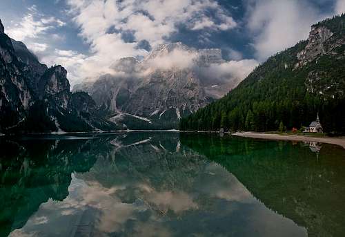
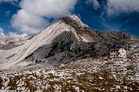
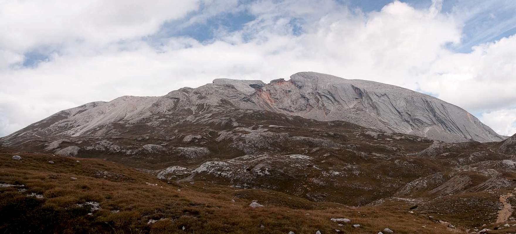
![Sas dla Porta]() Sas dla Porta above Pragser Wildsee / Lago di Braies Sas dla Porta above Pragser Wildsee / Lago di Braies |
easily is the most popular mountain of the
Prags / Braies Dolomites. Located at the language border of three people (German to the north, Italian to the south-east and Ladinian to the south-west) it carries three utterly different names. For this report I will use the least known Ladinian one. While not the highest mountain of the range -
Sas dla Porta comes in at number four - it is no doubt the most photographed one. However, more than 80% of the pictures are taken from the same spot, the northern end of
Pragser Wildsee / Lago die Braies, a dark mountain lake, spread out underneath the north face of the mountain. From this spot the north face apears to rise vertically for 1300m above the southern end of the lake, a perfect face for epic big wall routes. At closer inspection, however, the it loses its attraction. While no doubt steep, it is far from vertical and in the end it is made up from the horrible choss, which is so typical for the
Prags / Braies Dolomites. Climbing it could be lethal!
However, once you turn to the far side of
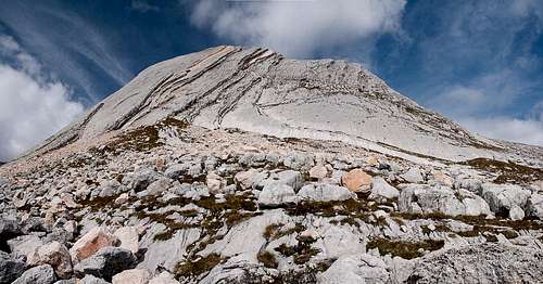
Sas dla Porta, aspects change dramatically. The south face is far from being as steep and high as the northern one, however, the rock composition is far more solid. Here firm limestone prevails which rises up to the summit in big 50° - 60° slabs. At a vertical height of 250m some of the slab routes reach up to 350m in length, the longest slab routes anywhere in the Dolomites. And there is an abundance of them. The face is divided in three sectors, all separated by brittle rockfall areas and each containing some 10 - 15 routes. The proximity of a climbing hut,
Seekofelhütte / Rifugio Biella, makes it one of the most attractive climbing destinations in the Dolomites, certainly by far the most attractive one in its own smaller subrange.
Sas dla Porta's famous south face slabs |
has been on my ticklist for quite a while. In 1999, when I first visited the greater
Pustertal / Val Pusteria area it frustrated any of my / our attempts. Like
Dürrenstein / Picco di Vallandro and
Peitlerkofel / Sas di Pütia it ranked among the must-go-and-climb mountains but somehow I could never make it. In 1999 the guidebook mentioning a protected section was enough to deter me but also my attempts to shoot the picture postcard picture from the lake were frustrated by bad lighting conditions. 10 years later, I set my mind to change all this and the following lines describe, how I set about to achieve these goals.
A First Sighting
A few days into our September 2009 vacation we decided to head for the
Prags / Braies Dolomites. The idea was to start at
Pragser Wildsee / Lago di Braies and hike a long loop across the
Foses Plateau to
Großer Roßkofel / Campo Cavallo and
Herrenstein / Sasso del Signore the loop was to end at the
Apostles before returning to the lake. We set out in perfect weather very early in the morning. From our base at
Sexten / Sesto we had to drive for half an hour before reaching the tollbooth at the lake. Though it was not yet 8 a.m. we already had to pay the 3€ parking fee and decided that we would be getting much more from it than the regular camera toting tourist as we would leave the car there for the whole day. It was bitter cold and we left in a hurry to warm-up during the hike.
Did I mention that the weather was perfect? Indeed it was. While we reached the northern tip of the lake, the sun started to rise across the ridge of
Großer Jaufen / Giovo Grande. Only
Sas dla Porta's summit ridge saw some light while the rest of the north face and the dark lake were still in the shadows. Glad about this perfect opportunity I shot two pictures. Lighting seemed so perfect that I didn't bother to check the results. I should have! Later I found that the top had been severely overexposed while the lake and its surroundings remained black. Photoshop could not recreate reality from these shots. I knew I had to return some day.
![Sas dla Porta]() Sas dla Porta above Pragser Wildsee / Lago di Braies
Sas dla Porta above Pragser Wildsee / Lago di Braies
But at the time I was still quite happy. We climbed the
Nabiges Loch gully underneath the east face of
Sas dla Porta and after little more than an hour headed out onto the karst plains and dolines of the
Foses Plateau. The mountain remained the main attraction for quite a while, until we had to pass to the far (eastern) side of the
Jaufen Ridge. There views switched to
Hohe Gaisl / Croda Rossa and
Dürrenstein / Picco di Vallandro, the higher neighbours of Sas dla Porta. Only after having reached the summit of
Großer Roßkopf / Campo Cavallo did it briefly return into our field of view, disappearing again for the remainder of the day. But wait! From a ledge traverse underneath
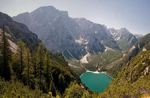
Herrenstein / Saso del Signore we suddenly had a short but perfect view of the north face with the green lake underneath. Here the sheer size of the face became apparent though lighting conditions once again prevented my being really happy. Later, back at the lake, lighting was abysmal and I quickly gave up hope, waiting for another time.
A few days later the mountain was visible from
Sarlkofel / Monte Serla, then again after returning to
Plätzwiese / Prato Piatta from
Dürrenstein / Picco di Vallandro. Finally, the huge slabs if the south face could be seen from the
Fanes Plateau as we frantically tried to find dry spots during 10 days of rain, which almost spoiled the whole vacation. Finally weather cleared up and after some hikes in the
Cadini di Misurina and the
Sexten / Sesto Dolomites we and the weather were ready for our attempt on
Sas dla Porta, this time approaching from the south.
A Roundabout Approach
![Crepe de Socroda]() Crepe de Socroda
Crepe de Socroda
I have learned that the more desperate you want to climb a mountain the less you must try to appear to care. Therefore no mention was made of
Sas dla Porta on that September 24th morning when at breakfast we decided on today's tour. The weather forecast called for clouds and rainy weather rolling into the area from the north in the afternoon so it appeared to be a good idea to drive to the south to have as long a stretch of sunny weather as possible. Therefore we decided to drive south to Cortina d'Ampezzo and hike the huge loop across the
Foses and Senes Plateaus, which several of our guidebooks recommended. At its northernmost point the loop would pass by
Seekofelhütte / Rifugio Biella and secretly I decided that an attempt of Sas dla Porta would be possible if only we eached the hut in time. But no mention of it was made though later I found out that Judith had had the same notion on her mind at that time.
So, to
Cortina we drove. You drive out the
Sexten / Sesto Valley, then drive a few km through
Pustertal / Val Pusteria, only to enter
Höhlensteintal / Valle di Landro at
Toblach / Dobbiaco. Drive through the valley at full speed, than cut accross the passes in direction of
Cortina. Right befor reaching the town, we turned right and north onto the narrow mountain road to Malga Ra Stua. Closed during summer it will be opened by mid September for the cattle to be transported down to their stables by truck. The road is so narrow that any oncoming car is a severe challenge let alone an oncoming cattle truck. But we had started early enough and reached the parking lot without any traffic challenge.
Now that we were at the trailhead we dared to have a look around. The weather was not perfect but fair enough. The north was still almost free of clouds, only in the east a thick layer was hovering around
Hohe Gaisl / Croda Rossa. Our plans called for hiking out
Val Salata a bit, then climb through the gap between the
Crepe de Socroda. We would end up on the
Foses Plateau from where we would cross over to
Seekofelhütte / Rifugio Biella. Anything beyond that point remained unformulated in thought.
So out the valley we went. Cattle transport was in full action as we left the parking lot. We followed a narrow mountain road for severall hundred metres until we reached the beautiful meadow at Cianpo de Crosc. Here our route left the road to the left and headed for the impressive wall of
Crepe de Socroda, which bounds the valley to the north-east. Again, closer inspection revealed the poor quality of the Prags / Braies limestone, a mass of orange choss. A quick hike through the trees at the bottom of the face and then a steep and winding path took us up to a saddle on top. While on our way a wonderful view along the
Crepe de Socroda revealed the faraway
Muntejela de Senes on the horizon.
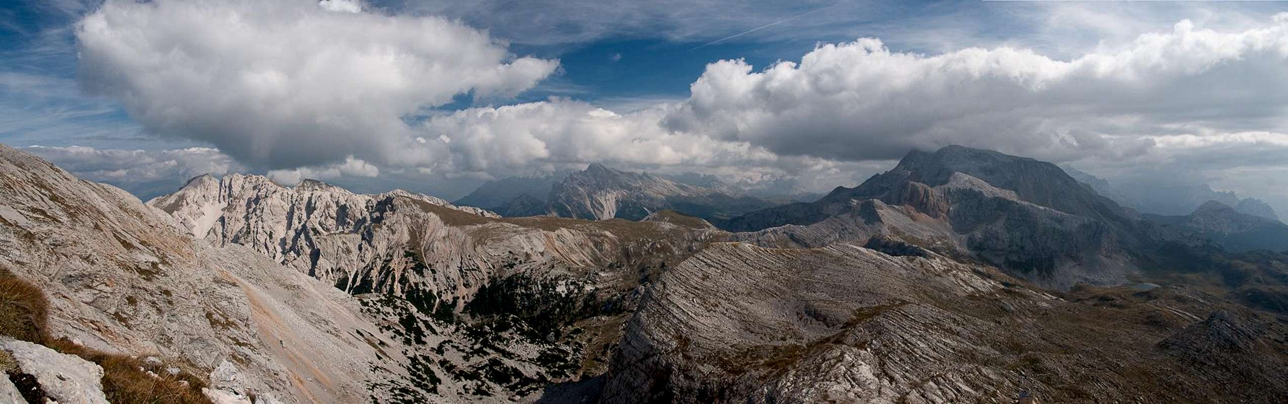
The Fanes Group seen from the top of the Crepe de Socroda |
On top a karst plain awaited us. We had to scramble out of the saddle onto the labyrinthine plateau, across and through which a winding path led. The hike was rather strenuous but boring as we had to hike through the lowest part of the plain and views revealed themselves only on few occasions. One was in a depression, from which we could look out across the
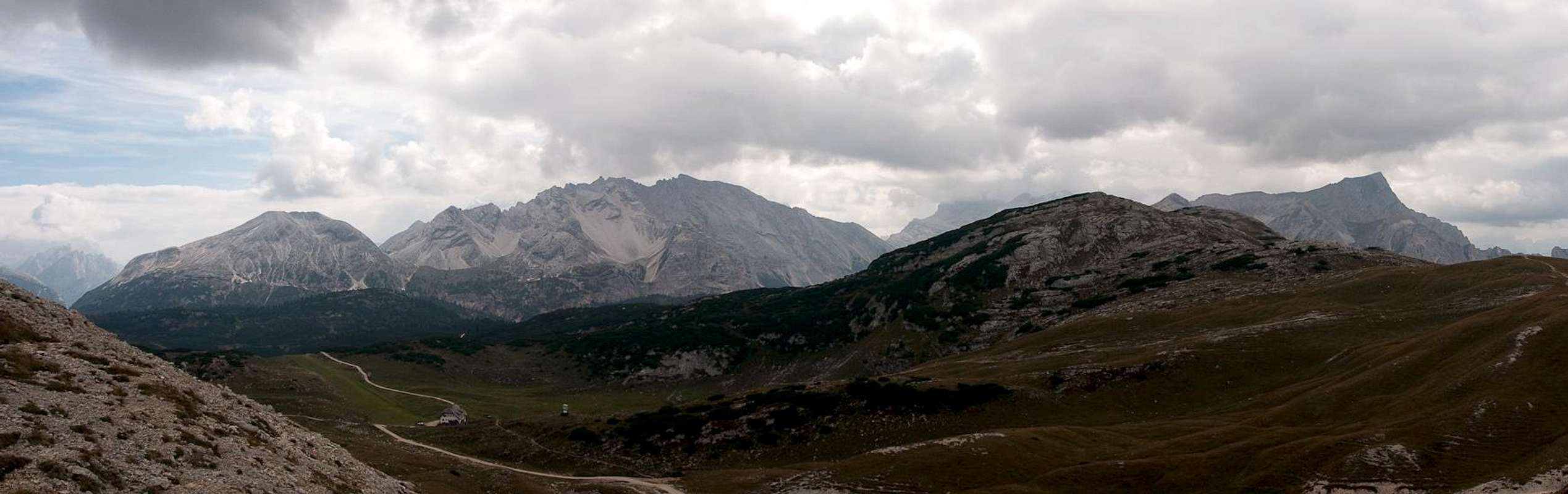
Fanes Plateau towards the eastern mountains of that group. In the south-west the
Tofane already were shrouded in clouds and we realized we didn't have much time to lose in order to reach the destination that must not be named. A bit later a similar view opened towards the north-west with a karst doline as the frame.
![Sas dla Porta]() The Foses Plateau seen from Crosc del Grisc
The Foses Plateau seen from Crosc del Grisc
We now reached our first highpoint at
Crosc del Grisc and suddenly the unnamed mountain made its appearance for the first time. It towered about
Lago Pizo and Lago Gran de Foses, which are embedded in beautiful mountain meadows. Down we went, first looping around the smaller of the lakes, then heading for the bigger one. There was no wind to speak of and it served as a wonderful mirror for the mountains beyond. In order to get the mandatory picture I waded through the fenn-like meadows and sank in down to my ankles. As I tried to get away I stumbled and splashed my way back to the meadows on the shore. My feet were still dry but the rest of my was dripping with ice cold lake water.
Now we headed out of the depression in which the lakes are based. Again we had to struggle to find and stay on the trail. Finally we headed out onto the next level of the plateau and there it was, the mighty unnamed mountain of our desires. Closing in across the karst it rose and rose, finally towering above
Seekofelhütte / Rifugio Biella in its trapeze-like shape. The east ridge, the normal ascent route, rose from the hut in a steeply swinging line and finally we were able to acknowledge: yes we came to this place to climb
Sas dla Porta. And we stood a fair chance of good weather all the way.
A Polished Ridge
![Sas dla Porta]() Sas dla Porta
Sas dla Porta
Now, nobody can claim that the ascent of
Sas dla Porta is difficult. It is very steep in its lowest section and there is some moderate exposure. In one place you basically hike out into the brittle east face but the trail switches back and heads away from immediately. Yet, thousands and thousands of hiking boots have left their marks on the rock, which has become as blank and polished as a bowling ball. On your way up you barely realize but upon descending some sections get outright scary. I hesitate to think wjhat the ridge would look like in wet conditions...
As it was not yet time for lunch we quickly passed the hut and headed to the trail intersection at the base of
Sas dla Porta's east ridge. A handful of Austrian hikers, who had come up from
Pragser Wildsee / Lago di Braies in the north had been taking a break in this place were getting themselves ready for the final ascent. We passed them with a friendly "Grüß Gott" and tackled the ridge. The path switched back and forth across the polished rocks, with several brittle sections in between. Prags / Braies limestone of course - either grey and solid or reddish and brittle. Not your favourite surface material!
The big karst plateau of Foses |
After passing the aforementioned balcony within the east face we reached the protected section. A chain is fixed across the ridge at a height of about two feet and quite honestly, it couldn't be placed worse. You have to step across it several times and though exposure in this section is still moderate it is an unnecessary dance you are forced to perform. After some 30 metres of chain the steep part of the ascent is over and the remainder is a hike across the upper slabs of the mountain. We quickly made it to the summit where only a pair, father and son, were staying. They greeted us in German but soon dad's cell phone rang and I realized they were Ladinian. I had never heard this language spoken and I must say it was quite an experience. It was here that I heared the name
Sas dla Porta for the first time and immediately decided to remember it for further reference. We looked for a good place to sit down and settled to have our lunch. Of course, we attracted the usual visitors: alpine choughs greedy for any crumb we would let fall.
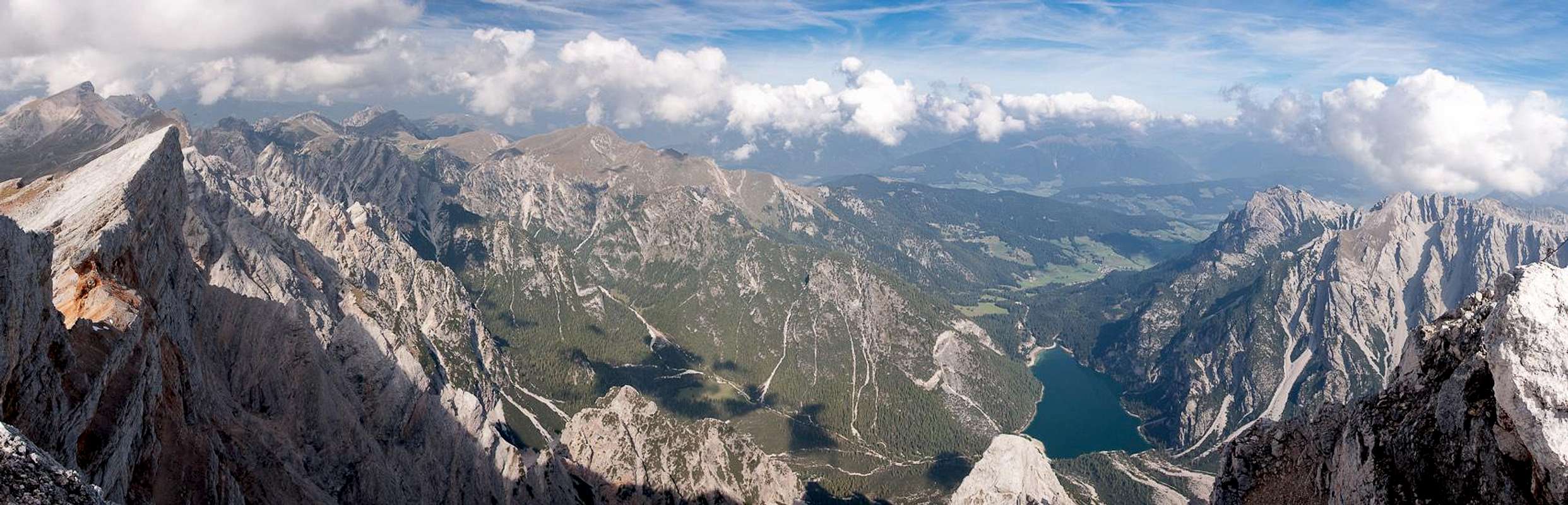
Summit view towards the north |
Summit view towards the east |
It was quickly getting cold now. The clouds we had been seeing all day finally moved in front of the sun and we hastened to get through our food. I scrambled along the topmost ridge of the mountain and took several pictures of the vicinity near and far. The lake 1300m underneath is a real show from up there but also the ridge towards the west with the overhanging summit of Kleiner Seekofel is worth remembering. Because of difficult lighting conditions I took several (overlapping) panoramas in different directions, some of which you can see here.
Down and Out
![Descending towards Seekofelhütte]() Descending towards Seekofelhütte
Descending towards Seekofelhütte
What remained of the day was to get down the mountain and out back to the car at
Malga Ra Stua. Clouds were piling up everywhere and it became obvious that we would have to make haste if we wanted to complete the intended loop. While the Austrians finally joined us on the summit and the Ladinians had already left we got ourselves ready and headed down. Upon descendin the chains appeared to be even more hazardous than before but taking our time we easily overcame this obstacle. As we entered the polished section a class of schoolchildren (aged around 15) headed up. Their equipment was far from perfect and I started to feel sorry for them as I anticipated some rain to come. Then I saw their teacher who clearly was fighting vertigo and I felt even more sorry for them. Since I didn't hear of any accident on
Sas dla Porta that day I assume they all made it down safely again.
Now we made it to the base and the trail intersection heading down the short path to
Seekofelhütte / Rifugio Biella. Weather was still ok and a small sunny window accompanied us for the next half hour. At the hut the landlord got himself ready to drive back to
Ra Stua with his antique red Landcruiser, which belted out giant clouds of pitch black diesel fumes. We kept our breath passing the car and heading for the trail / road underneath the south face of
Sas dla Porta. And this is the face of the famous slab climbs and currently lighting was simply perfect to showcase them. As we moved along and away from the face the wonderful aspect revealed itself. So very different from the north face above the lake on the other side of the mountain!
![Sas dla Porta south face]() The Sas dla Porta south face slabs
The Sas dla Porta south face slabs
But now the clouds pushed away any pieces of blue sky that were still left. Over at
Hohe Gaisl / Croda Rossa the sun was still shining but we seemed to be heading into doom. We crossed the karst plateau of Cianpo Ros cutting short a huge bend in the road, on which the old Landcruiser was slowly creeping away, still emitting black fumes. We calculated that at that speed we would arrive at
Ucia de Senes at the same time. This forecast proved to be exactly right as we found out half an hour later. We were on
Alta Via delle Dolomitii No 1 currently and thus routefinding was no issue here. Near the hut the plateau abruptly ended and we slithered down into the broad valley around
Munt de Senes. The Landcruiser had just arrived as we tackled the last 200m to the hut.
Our original intention had been to traverse the next karst plateau,
Plan de Lasta, towards
Ütia de Fodara Vedla, a hut underneath the north faces of the southernmost mountains of the
Fanes Group. However, we had been on our feet for 8h now and weather threatened to turn to rain and storm. Therefore I proposed to take the direct route anlong the mountain road through
Val Salata to return to
Rifugio Ra Stua and our car. Thus we would cut short the big bend at Fodara Vedla and save at least half an hour from our hike.
Looking across the Senes Plateau towards the south |
Though Judith didn't like the idea I pointed to the sky and she had to agree and we set out along the road. We immediately found that she was right not to like the idea as we were now in mountain biking territory. We didn't mind the bikers coming up too much - they were slow and stayed on their side of the road most of the time. But the downhill bikers seriously got on our nerves. They'd come around the corner at full speed, only nearly missing us and throwing stones and pebbles in every direction. I can't say I ever liked the sport ...
![Monte Cristallo]() Monte Cristallo
Monte Cristallo
The day ended with a final view towards
Monte Cristallo before we headed down into the valley. I got real cold by the time we reached the valley floor and the hike out to the Rifugio turned out to take much longer than we had expected. However, finally we made it and by the time we did all cattle transport activities had already subsided. Again the drive back along the narrow mountain road was no challenge - the same the drive in had been in the morning. Another half hour and we had returned to
Sexten / Sesto and relaxed in our apartment while the rain we had anticipated was falling outside.
The Day After ...
![Sas dla Porta]() The Sas dla Porta north face seen from Grünwaldtal
The Sas dla Porta north face seen from Grünwaldtal
... we once more were in the spell of
Sas dla Porta. After last night's rain and considering the forecast it had appeared to be a good idea to do something in the vicinity of
Pustertal / Val Pusteria. The deep valley heats up quickly in the sun and through the chimney effect the warm air will rise, pushing the clouds to the mountains on its outskirts. We intended to climb as many mountains of the
Olanger Köpfe as possible, which are the northern boundary of the
Prags / Braies Dolomites and the southern boundary of
Pustertal / Val Pusteria in this section. Again we were to start at
Pragser Wildsee / Lago di Braies so that I had my second chance for the picture postcard view (you can see it on top of this TR). Again we were haunted by clouds and fog, even worse than the day before, but as we returned through
Grünwaldtal / Val di Foresta we had a wonderful good-bye view of the massive north face of
Sas dla Porta.


Comments
Post a Comment