
-
 21594 Hits
-
 0% Score
-
 0 Votes
|
|
Route |
|---|---|
|
|
53.47906°N / 9.81079°W |
|
|
Strenuous Hike with some scrambling |
|
|
Most of a day |
|
|
Strenuous Hike |
|
|
Approach
The main Galway Clifden road (N59) runs directly by the south of the horseshoe. Galway city is about an hour and twenty minutes drive from the area. If coming from Galway city, go west through Moycullen and Oughterard and Maamcross, toward Clifden. After passing through the village of Recess, take the second right hand turn onto a bohereen and follow it for about a kilometer. There are a number of unofficial parking spots in the area, though do take care not to park in a farmer’s yard or block the road. |
Route Description
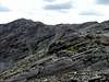
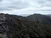
When turning off the Galway-Clifden road, proceed along the bohereen in a north-easterly direction until the slopes of Derryclare become visible on your right. Walk up the slope either along the long ridge, or by scrambling up any of the gullies that traverse its western face. Once the summit cairn of Derryclare (677m) is reached, you should have a good view down into the horseshoe on your left, as well as of Bencorr directly to the north, with Bencollaghduff off to the north-west slightly. Follow the ridge up to Bencorr (711m) and enjoy the views down to the right to Lough Inagh, with the Maamturk mountains looming over on its far side. Though not part of the ridge walk, there are some particularly fine opportunities for rock climbing and scrambling on the spur leading north east from Bencorr (Bencorrbeg). From Bencorr, a steep descent into Devils Col, followed by a sloping rock ascent, leads you to the summit of Bencollaghduff (696m). Benbaun, the highest mountain in Galway at 729m, looms its bald head above to the northeast. This peak is not part of the horseshoe, but can be attempted if the walker feels like an additional challenge.From Bencollaghduff, a gradual descent to the col below Benbreen is next, followed by an ascent - which may involve some scrambling - to the long ridge which traverses above a hanging valley to the top of Benbreen (691m). The route from Benbreen toward Glengower is quite steep, but does contain one of the finest scree runs in Connemara, which should assist the descent somewhat. Glengower (664m) is reached after a steep ascent with plenty of opportunity for scrambling.
From Glengower, the walker can go one of two ways; either down to the left into the Glencoaghan valley and back to their car, or continue toward Benlettery (577m) and from there to the Clifden-Galway road.
No Connemara walk is complete without a trip to Keane’s Pub in Maam. This can be reached by car by following the N59 back toward Galway city. Take a left turn at Peacocks Hotel in Maamcross and follow the road until you come to a T-junction, where the Pub is directly in front of you. Rest your weary limbs and glory in a pint and a toastie in front of the fire.
 |  |  |  |  |