
|
|
Hut/Campground |
|---|---|
|
|
50.73600°N / 15.74000°E |
|
|
Spring, Summer, Fall, Winter |
|
|
5256 ft / 1602 m |
Overview
Attention!
As for now (June 2020) the hut is closed!
Śnieżka
Śnieżka is the highest peak in Sudety Mountains and at the same time the highest mountain in Czech Republic. It rises 1602,25 meters above the sea level, although the latest measurements states it’s 1603,15 meters high. The prominence of the peak is 1202 m.
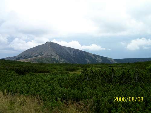 Śnieżka- 1602 m
History

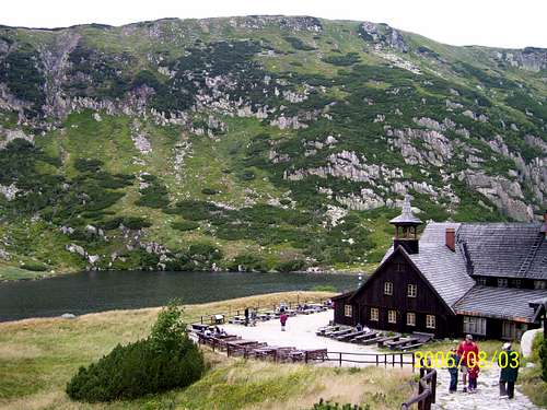
The hut

Chappel of the Saint Lawrence

The marker on the top
The hut
Śnieżka is a tourist attraction since XVII century. Although the first notable ascent took place in 1465, Śnieżka started being popular among tourists in 1681, when the Chappel of the Saint Lawrence on the top was biult. The biult took 15 years, and was sponsored by Count Leopold von Schaffgotsch. Since 1708 regular masses had been celebrated in the chappel so the peak was ascended by tons of pilgrims and wanderers. Hundread years later the masses stopped being celebrated and the building was empty for over 10 years. Here starts the origins of the hut on the top of Śnieżka: Karol Siebenhaar was giving meals to the tourist and they may use the biulding as a shelter. The idea made ‘strike home’, so in 1850 a big hostel was erected next to the chappel, but unfortunately it burnt down 7 years later. In 1862 another hostel was built and it prospered to 1967.
After Second World War became a border mountain between Poland and Czechoslovakia. In 1949 Czechoslovakians biult a chair lift to the top which is now the oldest construction of that type- it increased the amount of tourists visiting the top so the Poles started to create plans of rebuilding the Polish hut. The execution of these plans took place over twenty years after the war. The built started in 1969 and finished in 1974. The project of three conected plates was created by W. Lipiñski and W. Wawrzyniak. At the same time the old hut was demolished and the road to the top was rebiult.
The new building consits of three parts (plates);
- the lowest and the biggest: restauration, buffet and administrative rooms.
- the medium: rooms and observatory.
- the highest and the smallest: meteorological observatory named after Tadeusz Hołdys.
The hut doesn’t belong to PTTK (Polskie Towarzystwo Tuystyczno-Krajoznawcze).
The meteorological observatory
Śnieżka is widely known for meteorological observations made from the top. The first observatory was created in the hostel in 1880, 20 years later a separated observatory was built on the top, and another 5 years later firs road to the top.
The whole history about the meteorological observatory on the top of Śnieżka you can find here.
How to reach the hut?
Getting there

Marked trail via Kocioł Łomniczki

Marked trail via Obri Dul
Polish side:
Starting point for the majority of routes (and the shortest one at the same time) is Karpacz. Karpacz is reachable by bus or car from Jelenia Góra, a town located about 100 km west from Wrocław (Breslau).
Czech side:
The city located at the bottom of Śnieżka is Pec pod Snezkou. To get to Pec pod Snezkou you must first go the city of Trutnov- quite big city, about 60 kilometers east from Liberec.
Access
From Polish side there are plenty of possibilities:
- red marks via Kocioł Łomniczki to Równia pod Śnieżką and then by a road or the black marks: 2,5- 3 h. (Attention: closed in winter- avalanche danger!)
- by the road: 3,5 h (with Samotnia variant 4 h- blue marks)
- black marks to Równia pod Śnieżką: 2,5 h (very steep, reccomended for descent). (Attention: closed in winter- avalanche danger!)
- black marks to Sowia Pass and then by red: 3,5-4 h.
- red marks from Okraj Pass: 3h.
The detailed descritpion of the routes you find here:Polish side.
From Czech side there also a few very interesting routes that leads to the summit:
- Obri Dul route- the most interesting one: blue marks, 3 hours to the top from Pec pod Snezkou.(Attention: closed in winter- avalanche danger!) More details here: Obri Dul.
- Ruzohorky route: green then yellow marks: 2 h. Goes, generally speaking along the chair lift. More details here: Ruzohorky.
- ‘Traverse’- goes parallel to the Obri Hreben (East ridge of Śnieżka), starts at Okraj Pass, 2,5h (yellow, green and yellow again).
- other possibilities goes via Lucni Bouda (1410 m)- from there to the top by blue and black marks: 1h.
Trails from both sides go through national parks- be sure that you respect the rules!
Karkonoski Park Narodowy- Poland
Krkonossky Narodni Park- Czech Republic
The hut
Informations about the hut:
- height: 1600 m.
- phone: +48501476713
- e-mail: toporowicz@sniezka.karpacz.pl
- the restaurant opened from 9 am to 5 pm, whole year round
- the Ecological Education Centre in the observatory opened from 10 am to 4 pm, whole year round
- ATTENTION: officially the hut on the top of Śnieżka doesn’t provide rooms for tourists! (in really bad conditions, I suppose, the overnight standing is possible).
Transit to other huts
 Samotnia
Polish:
- Śląski Dom (on Równia pod Śnieżką)- 20 minutes
- Nad Łomniczką- 75 minutes
- Strzecha Akdemicka- 75 minutes
- Samotnia- 1,5 h
- Odrodzenie- 2,5 h
Czech:
- Chata Jelenka- 75 minutes
- Lucni Bouda- 1 h
- Spindlerova bouda- 2,5 h