
|
|
Route |
|---|---|
|
|
44.07405°N / 113.72636°W |
|
|
Mountaineering |
|
|
Spring, Winter |
|
|
A long day |
|
|
Rotten rock, steep snow |
|
|
Class 4 |
|
|
Overview
 The upper mountain is a complex jigsaw puzzle of of rotting towers, wrong way chutes, and blind corners leading to dead end walls.
When viewed from Highway 93, this route looks like a continuous line of moderate angled snow shaped like a dogleg. Upon closer inspection however, one can see the route could potentially be a confusing mouse maze of rotting towers, wrong way chutes, and blind corners leading to dead end walls. I’d taken a photo of the route in December 2008 and was trying to drum up a partner for the climb, my selling points for the trip were; I didn’t believe Bad Rock peak had been climbed in the winter season and I was pretty sure the mountain had never been climbed by its West face. One prospective partner, while inspecting the photo, pointed out the snafu potential and encouraged me to memorize the route before giving it a go, his comment went something like; “hey, if you get lost in there, it could be a while before the grownups arrive to escort you back down”. As it turned out, the weather and my schedule necessitated a quiet, solo climb.
This is a good all-around snow climb that has a little bit of everything; Sections of steep rotten mank, narrow chimneys and route finding snags that will keep your head in the game. Firm snow conditions are an important factor for this route, too much new snow and the avalanche potential would be very high. The same goes for climbing the route in warm or late day conditions. The afternoon sun warming the snow at the base of the rock bands could be disastrous. Climbing it in summer without any snow would be a scree filled misery.
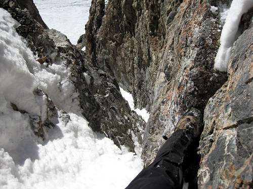 The second chimney, easier class 4 climbing but a fall here would still mean a long pinball style "down climb"
 The lower route starting in the upper Lone Cedar Basin climbs a shallow snow filled alluvial gully
Getting There
From Mackay, drive 11.4 miles northwest on Highway 93, toward Challis then turn right onto Lone Cedar Creek road. At the large ranch house, turn left off of the county maintained road and drive around the end of the wire fence, continue another mile up the canyon and park at the end of the road. Work your way through the narrows and into the upper basin. The route to the saddle becomes more and more obvious as you climb higher into the basin. The approach from Sawmill Gulch:From Mackay, drive 13 miles northwest on Highway 93, toward Challis, then turn right at the Sawmill Gulch jeep road. A high clearance 4WD will take you to the first switchback about 2.8 miles in. park there and located the old trail in the trees on the south side of the road. When you reach the end of the plateau at about 9,700’ you can see Leatherman pass and the head of Lone cedar creek canyon. Drop down into the canyon to the end of the approach or climb up and over Leatherman””” peak by its standard West ridge route.
Route Description
From Lone Cedar Creek’s upper basin, climb any of the alluvial gullies that lead to the start of the maze. The entire upper mountain drains down into one couloir and that couloir ends at a 40’ overhanging cliff. To bypass this obstacle and the crux of the climb, move left to a narrow class 4, seventy foot chimney, at the top of the chimney, you’re your way back across a steep snow covered ledge back to the couloir. Continue up and past the tempting couloir on the right and climb the 40’ easy class 4 chimney that cuts deeply into the right side of the cliff face. You can bypass the second chimney by following the snow to the right and then crossing a small rock band to regain the route. From the top of the chimney the route opens up onto a wider snow chute. One is again tempted to climb toward the West ridge because the route looks like a dead end near the summit but only one rotten class 3 section guards access the summit ridge. From there it’s and easy scramble to the top. If there is enough snow on the mountain, this last obstacle is covered over.External Links
Lopez GuideLost River Ranger District Salmon Challis National Forest Service.
Sawtooth avalanche page for current conditions within 5o miles of Bear Creek
Idaho Outdoors Forum
For more information, post a question to locals on the forum.