
|
|
Route |
|---|---|
|
|
29.19770°N / 103.3118°W |
|
|
Hiking |
|
|
Winter |
|
|
A few days |
|
|
Strenuous |
|
|
Overview
The Outer Mountain Loop is a 3-day hike in Big Bend National Park. It traditionally starts at the trailhead in the Chisos Basin, leaving the Lodge area by way of the Pinnacles Trail. You then follow the Boot Canyon Trail to the Juniper Canyon Trail, which leads out of the Chisos Mountains to the southeast. This trail deposits you at the eastern end of the Dodson Trail and your first night's camping spot. On the second day you traverse the Dodson Trail and end up at it's western terminus, the Homer Wilson Ranch. This is near the Maxwell Scenic Drive and there is a metal box where you can stash the third day's water in advance. You can camp a little way up the Blue Creek Canyon and prepare for the last day of hiking. That third day starts with a 5.5 mile hike up the Blue Creek Canyon Trail, which takes you back into the Chisos Mountains. At the junction with the Laguna Meadows trail you have about 3.5 miles of mostly downhill hiking back to the Basin. The total distance covered is about 32 miles.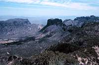 The hike begins and ends in the Chisos Basin.
Getting There
Big Bend National Park can be reached by taking US Highway 385 from Fort Stockton, which is on Interstate Highway 10, the freeway that runs from El Paso to Houston on it's way through Texas. Midland/Odessa and El Paso are the closest airports.Route Description
The Pinnacles Trail is a 3.5 mile trail which carries you up and out of the Chisos Basin with about 1400' of elevation gain. It is steep and rocky in spots with several switch-backs. We spotted several Sierra del Carmen Whitetail Deer during the climb and the close-up views of the pinnacles and other rock formations are quite good. When you top out at the first saddle, the view of the Basin behind you is spectacular. Once you pass this point there are some good views of the Sierra del Carmen to the east in Mexico. You can also see Emory Peak, the high point in the park at 7832’. You pass the beginning of the Emory Peak Trail as you head for Boot Canyon: the Boot Canyon Trail commences at this point. Soon there is also a good view of the rock formation know as "The Boot" off to the east. Once you are in Boot Canyon proper, the trees are quite large, especially the Arizona Cyprus. The Juniper Canyon Trail begins here with a steep climb up to about 7000'. Then it leads steeply down the face of the Northeast Rim until you level out and head down an old road bed. After over 6 miles of downhill hiking, you reach the gravel parking area which used to be the Juniper Canyon campsite. The Dodson Trail begins here and there are several flat, cleared areas suitable for a couple tents. The second day covers the Dodson Trail, crossing the eroded desert terrain with the elevation varying between 4000' and almost 5200'. When you reach the final saddle before you descend to the Homer Wilson Ranch, we've found that there is good cell phone reception. After you pick up your water from the storage box near the Maxwell Scenic Drive, you hike up the Blue Creek Canyon Trail to locate a camp site. We found a grassy area north of the dry wash that serves as the trail at this point. This trail has many interesting volcanic rock formations as you move up the canyon, following the Blue Creek dry wash much of the time. This makes the walking more difficult for old guys after two days of rugged hiking. Finally the trail moves steeply up the slope toward the Laguna Meadows Trail. The last mile gains about 1000' of the total 2800' you ascend in the 5.5 miles after leaving the Homer Wilson Ranch. The Blue Creek Fire roared up this slope in 1989 but was stopped before it entered the Basin. The last 3.5 miles leads through Laguna Meadows and then down through forested slopes to the trailhead in the Basin. Your net elevation gain is zero, but you do about 6800' of climbing during the course of the hike. Boot Canyon has an active stream after significant rains.
 The Juniper Canyon Trail descends to the east into this broad valley.
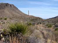 The Dodson Trail provides many close encounters with desert vegetation.
 Essential Gear
You start with food for 3 days and water for 2 days. Even in the winter they recommend 1 gallon per person per day in the Big Bend. This hike is not done in the summer because you just can't carry enough water and there is little or none available along the trail. I've done part of the Dodson Trail and the Elephant Tusk trail to the base of the Tusk in March, and one gallon a day wasn't enough. Even in the winter the temperature can reach the 80's and even the 90's. For such days sunscreen is a good item to bring along. It was cold the day we started and a jacket was nice to have. At night the lows can go well below freezing, so a warm sleeping bag and long johns are very useful. You need a small camp stove for cooking because no open fires are allowed. Also, because daylight is limited in the winter one should hike with a good pace to cover the distance to the next campsite before dark. Flashlights and plenty of fresh batteries are worth the weight. There is a plethora of desert vegetation along the Dodson Trail that has thorns and other sharp edges. It encroaches from both sides of the trail and jeans are the best way to protect your legs. It was warm enough to hike in shirt sleeves, but your hands and arms are then fair game for the trail-side plants. A walking stick is very useful for brushing aside the most threatening branches. A good camera is great for all the scenery you'll want to capture for posterity. The path is fairly easy to follow, but I have a friend who lost his way on the Dodson Trail and had to bushwhack his way back to the Maxwell Scenic Highway. A good topographic map and a compass should be part of your gear. The stashed water by the Homer Wilson Ranch adds some weight back to your pack, but even on a mild day we finished the final stretch with only about 2 liters to spare. A first aid kit with plenty of treatments for blisters and the scratches is essential. Your zone camping permit can be obtained from the Visitors Center at Panther Junction.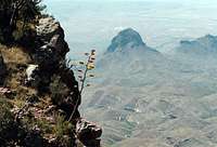 The Dodson Trail crosses the desert below the South Rim.
 Looking back down the Blue Creek Canyon as the trail climbs up into the Chisos Mountains.
External Links
http://www.nps.gov/bibe/planyourvisit/take_a_hike.htmhttp://www.nps.gov/bibe/planyourvisit/bc_outermountainloop.htm
Wildlife
There is wildlife to be seen along the trail, even in winter. We saw numerous Sierra del Carmen Whitetail Deer during the first day in the Chisos Mountains. There were bear droppings at several places right on the Juniper Canyon Trail and some fellow hikers spotted a bear near Fresno Creek along the Dodson Trail the next day. I have seen 4 bears in the Chisos Mountains, but none since 2001. A recent dry spell cut the population to about 12 in the entire park. Some died and others made their way back into Mexico. Among the birds we saw were Scrub Jays, an Acorn Woodpecker, and several Scaled Quail. There was even a small snake lying right in the trail: I almost stepped on it. In the spring of 2007 we encountered a much larger Bull Snake right on the Dodson Trail, one of three I've seen in the park. We also saw a Mule Deer with a nice set of antlers last spring closer to the Homer Wilson (also called the Blue Creek) Ranch, but saw none on this hike.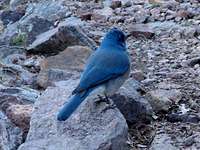 One of several Scrub Jays seen along the Pinnacles Trail.
 A Sierra del Carmen Whitetail along the Juniper Canyon Trail.
 A small snake encountered along the Dodson Trail where it follows a stream bed.
 Bull Snake blends in with the desert.
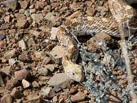 Bull Snake seen along the Dodson Trail.