Wednesday
![Rio Grande Pyramid-The Window]() The Window and RGP as viewed from The Skyline Trail.
The Window and RGP as viewed from The Skyline Trail.
I had attempted Rio Grande Pyramid about two weeks ago (Oct. 15th) during an ill-fated, storm washed weekend. Most of that weekend had either draped the mountains in a fresh coating of white or completely erased them with varying levels of gray clouds. It had taken me somewhere in the neighbourhood of six hours to drive to the 30-mile campground which serves as a predominant trailhead/launching point for Rio Grande Pyramid and indeed, the
central Weminuche in general. The flurries I was driving through as I crested Slumgullion Pass, south of Lake City had turned into an all out blizzard by the time I reached the turn-off for
Forest Service Road #520. I drove the remaining 9 miles (14.5km) to the campground anyway and figured this would be a good time to at least get some MUCH needed sleep. When I woke up five hours later around 1:00am, there was 4-5” of snow on the ground, clear skies and it 19°F outside.
To be honest, I didn’t feel like leaving my warm truck and staking out for 4 miles under a new moon through untracked snow on a trail I was unfamiliar with in an area I was unfamiliar with. So I scrapped my plans in lieu of more sleep, breakfast in Creede and vowed to return soon. Two weeks later, I posted an invite at
14ers.com, a Colorado specific mountaineering website for interested parties in RGP. I received two inquiries. After exchanging multiple e-mails, I met my partner for this trip, Glen Maxson. After dispensing with the usual platitudes and gear shuffling, we left Loveland for southern Colorado for what would become three of the most enjoyable days I’ve had in all 2007.
Glen and I arrived at 30-mile campground under crystal-darkening skies and a brilliantly full moon rising in the east. In my opinion, October is one of Colorado’s better months to get outside. Other than a couple of large horse-trailers & hunters that we passed on the drive in, there was no one parked or camped at the large campground. We were the only ones. And as events would have it, we would end up seeing no one for the span of the entire trip.
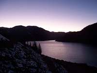
![Sunset on Rio Grande Resevoir]() Sunset over Rio Grande Reservoir
Sunset over Rio Grande Reservoir![On the connecting Ridge...]() Glen on the connecting ridge. Looking back to the southeast.
Glen on the connecting ridge. Looking back to the southeast.
We left the trailhead a little after 6:30pm and proceeded onto the trail. A left turn would take us onto Big Squaw Creek Trail and a right, Weminuche Pass trail (#818); a right it is then. This is a long trail. It starts out by paralleling the Rio Grande Reservoir for near 700-730m before banking sharply left up a side canyon. Glen and I, toting 30-35lb. (15kg) packs made excellent time up this side canyon to its head with a southern higher meadow. There was still snow and ice on the trail from the two previous storms but due to the warmer weather (common for Colorado), the trail had turned into a veritable hopscotch mud highway. I use the term highway because the heavy use of horses from hunters in previous days had turned the footpath as such. For those who think mountain bikers do considerable erosion damage to trails, I say take a look at a pack trail (after a storm) or snow melt and revise your opinion.
Our pace slowed a little once we came out of this dark canyon. Up in the high meadow, the moon was amazing; a bullet hole in a dark void is what I kept thinking. The trail stayed to the western side of this meadow about 40ft. (12m) above the valley floor. Our plan was to camp at Weminuche Pass. We had no time-obligations or restrictions but kept up a moderately brisk pace anyway. The air was just cold enough to make things uncomfortable when we stopped but the moon kept tugging at us to stop anyway at every clearing and dwell on the meadow and oxbow creek below. In the ~4 miles from the trailhead to Weminuche pass, the trail only gains about 1,300ft (397m). Once we reached the pass, we found a sweet copse of trees that had a clearing in the center and unobstructed views down-valley to the west. As tempting as sleep sounded, so did having a hot meal. So after some Alfredo that Glen cooked up and a few swigs of Grand Marnier (yeah, we ate good on this trip!), we climbed into a cold tent and (very) quickly fell asleep in the dead silence and the occasional lonely cries of the coyotes.
Thursday
![Rio Grande Pyramid]() Rio Grande Pyramid as viewed from Point 12,911
Rio Grande Pyramid as viewed from Point 12,911
Rio Grande Pyramid is first and foremost a trekking peak. It is one of Colorado’s centennial peaks (
top 100 highest) coming in at 13,821ft. (4213m) and is consequently, one of the most isolated and difficult to reach. There is nothing particularly difficult or technical about the climb albeit for a southern couloir and a northern couloir (Rio Nieve) which would make for some decent snow climbs if one wanted to invest the time in reaching it during the winter, quite an undertaking indeed.
Rio Grande Pyramid sits at #97 on the centennial list in the northern part of the Weminuche Wilderness. This is Colorado’s largest wilderness area weighing in at nearly 500,000 acres (202,343hectares) and ranges in elevation from 7,900ft (2,408m) of the Los Pinos River to the lofty confines of Mt. Eolus at 14,083ft (4292m). The Chicago Basin (
Sunlight Peak,
Windom Peak, etc.), No Name Drainage, Ruby Creek, The Grenadiers and the Piedra area are included in this to name but a few places. In 1980,
Goose Creek (to the east) was added to the Weminuche increasing the size by another 60,000 acres and later on in 1993, the Needle Mountains located in the western stretches was added to the wilderness designation. Lynx were introduced in this wilderness back in 1999-2000 with an additional 150 animals released in subsequent years. Because of the large Elk population here, the Weminuche is also a strong candidate for wolf re-introduction, a hot-button topic here in Colorado. Moose have also been introduced here with successful results and
wolverine can also be found. The Weminuche have no roads to gain access except for the almost 475 miles (764km) of crisscrossing trails. The Continental Divide Trail (CDT) lays claim to 80 miles (129km) of that total alone as it serpentines through this pristine backcountry connecting all the drainages in one fashion or another. “The Window” is also supposed to mark the vicinity of a lost 1750’s Spanish gold mine!
Glen and I woke a little past 7:00am to an expectantly cold morning. We didn’t feel the need to set an alarm. October sees a drop in expenditures by people into the backcountry, mostly by fair-weather hikers due to the temperatures, snow and starting grade school (children-families). With the colder temperatures, thunderstorms are also thankfully absent. So we woke up naturally. Glen cooked up some oatmeal and beans and we warmed up with some coffee that he had brought. The Nalgenes® (water bottles) weren’t frozen but they were sufficiently slushy. I looked up and gazed out down the meadow,
“Dude! Isn’t that a pair of moose crossing down there?” I said with some excitement. Glen turned around and stood up and agreed that it was indeed. It was his first time seeing them in the wild and my second. That gave us all the motivation we needed to get going.
Let me say that the trails coming off the pass are poorly marked (for future endeavors).
![Looking down the South couloir]() From near the top, looking down the south couloir.
From near the top, looking down the south couloir.
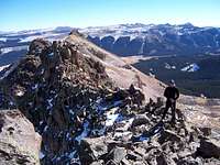
We had entirely missed our trail of choice, the Skyline Trail (#564), now renamed the Opal Lake Trail by the Forest Service, and so after scouting the ridge to the north we pretty much just decided to bushwhack up the ridge. We knew the direction we needed anyway. We passed by a hunting camp lower down in the forest (saw a couple tents and some tethered horses). The hike up the ridge was pretty straightforward through scant growth (clearings). We actually ended up coming up on the Skyline trail anyway. We took a left and followed it up into another higher valley. It stays high along the valley wall as it hugs the Continental Divide. Once we reached treeline, Rio Grande Pyramid and “The Window”, 12,857ft. (3919m) came gloriously into view! I had waited to see this for three years and Glen since he was 12 years old! We stopped for our first of many breaks and drank in the view. The sky was antartic blue and no clouds were present anywhere. There wasn’t even so much as a whisper of wind. We could hear the mud actually slowly crack and melt from the previous nights freeze! It was seriously amazing. We kept walking on and eventually cut up another slope to gain the ridge proper. I wanted to stay high and get to Point 12,911 (3935m). This was a broken, craggy volcanic mess.
![Myself on the connecting ridge]() Myself on the connecting ridge en route to Point 13,287
Myself on the connecting ridge en route to Point 13,287
You could actually pick up pieces of pumice. This was something I didn’t realize. Glen mentioned that the entire area from Creede south to Snowshoe Mountain to Bristol Mountain to RGP and south to the Divide had once been a super volcano, similar to what Yellowstone is now, extinct now of course but evidenced in the rock, cliffs, ridge’s and hidden geology. Instead of staying high, we dropped down and checked out some funnels and gray slopes. These actually reminded me of what
Potosi Peak has on its’ southern slope. I wanted no part of that. We ended up crossing a huge gray funnel that was really nothing more than a soft layer of dirt on top of hardened ashstone?
![The Window]() The Window
The Window
I don’t know but I did know, a slide/slip here would have some serious implications. When viewed from the Rincon La Vaca trail later in the day (other side of the valley), this slope funneled to a small cliff. We gained the other side, up some tundra and crossed an interesting broken volcanic ridge. Out of the whole day, this was really the only exposure we would encounter. From the ridge, we spied a line of Elk of at least 30 animals moving swiftly across a talus field to the north. It looked, at least to us that they were running from something, the hunters perhaps? We didn’t know. We heard no reports. It’s amazing how quickly an animal of that size can move. Once off the ridge it was an easy stroll of class-1 to the summit of Point 13,278 (4047m). We stopped for the usual pictures, signed the register, I noted some familiar names and we moved on down to the saddle (12,645ft) with Rio Grande Pyramid. There was at least a decent amount of snow on the western slopes but it disappeared at the saddle. We were both pretty surprised at how scant the snow was. I was glad I left my winter boots and ski jacket at home and Glen, for leaving his snowshoes at the house. The climb up Rio Grande Pyramid’s eastern slopes had a fair amount of snow still. In some places, we post-holed up to our thigh. So at that point, we did what we could to stay on the rocks (which wasn’t hard to do). We crested a minor low false peak and started up the last remaining bit of slope and finally reached the large, flat summit! We were both surprised when viewing what lay before us from the saddle, how quickly we ascended. We were the first ones up there in a little over five weeks! The slope couldn’t have been more than class-2 at most. Like I said, not difficult, just remote.
We stayed for 15-20 minutes. We scouted out the backside to spy a more convenient route down to “The Window”. This is where we found this wonderful southern couloir.
![Southern view of Rio Grande Pyramid]() Rio Grande Pyramid as viewed from the south along the flat, tundra ridge
Rio Grande Pyramid as viewed from the south along the flat, tundra ridge
It was loose with every sized rock you can throw into something like that. It would be an irritating nightmare to have to ascend it without snow. The dirt portions were still soaked from snowmelt, so we either rock skied or we slid down on the mud (when encountered). The (tundra) ridge was pretty flat all the way to “The Window” and knowing that we faced a sheer wall when we got there, we contoured down the slope to get into “The Window” instead of at the precipice. It was surprisingly larger then what we both were expecting. Huge chunks of rock lied on both sides of the ridge. This ridge is actually a horizontal volcanic dike extending from Rio Grande Pyramid. So, I guess that would explain somewhat how a geometric piece could literally fall out of the ridge. It’s still amazing to look at though. The rock consisted of a strange, cemented sand appearance with conglomerate thrown in.
I wanted to ascend the other side to summit Window Peak but we were running out of time. It was at this point close to 5:00pm. And I was completely out of water. I’d been running on snowmelt since Point 13,278. Luckily, I found out a cool unintended consequence to filling the black aluminum Sigg® bottle I had with me with snow. The bottle heated up quickly when in the sun! So I was able to keep just enough water handy until we reached a lake (12,320ft) just below “The Window”. I had left my Steripen back at camp and wasn’t content in waiting 2-3 hours for chlorine tablets to take effect. We filled up at a spring above the lake and I drank greedily; cold water but absolutely clean tasting. We took the Rincon La Vaca Trail out and finally after 13 hours, arrived back at camp, again, in the dark. We settled in to another hot dinner, and this time, a campfire.
After being thoroughly relaxed by the fire, we turned in around 10:00pm.
Short 360° vid from the center of the connecting ridge with Point 13,278.
FYI-
Did you know, the reason why campfires are so relaxing is that the wavelength (λ) of light emitted is of the same frequency (υ) as what’s emitted by your television? Thanks, Glen for that beta! Some cool stuff!
Friday
![In the Window...]() Glen perched atop a spire inside The Window.
Glen perched atop a spire inside The Window.
We woke the next morning, finished what was left in our packs for food, packed up (it was noticeably colder) and briskly hiked back out to where a few beers were waiting eagerly for our return back at the car (or vice-versa). We saw the moose crossing the meadow again but much further down. We stopped at the footbridge located in the side canyon and filled up. We nuked the water with my Steripen and moved on.
We thanked Josh Harnett and Harrison Ford and Stewie from Family Guy for keeping the conversation lively and entertaining for the course of our time.
During the whole time, we never saw a single cloud, it was never windy and it warmed up during the afternoon enough to warrant shorts (though we didn’t have any).
Everything about this trip was enjoyable. We stopped off in Monte Vista for lunch before the long drive back home to Loveland where I immediately turned around and went to work. I will definitely return.
5,211-v-ft.
24.3 miles
After thoughts and notes:
The Skyline/Opal Lake Trail (#564) is poorly marked and from the main trail, looks like a rivulet. In fact, on the older quads, it’s not even listed. Only after starting to hike out did we realize why we missed it on the way in, the signpost had fallen over. We corrected it and braced it further with rocks. Look for it on the right side just past the crest of the pass.
For those doing this peak in winter or autumn, Roach is right. If there is no snow, water is scarce at best once the pass is reached. There is a ditch (the Raber Lohr Ditch) about 5 minutes walk south off the main trail but I wouldn’t trust the water. It looked pretty sketchy. We had to collect some but we boiled the shit out of it.
If you wanted to continue past Weminuche Pass and set a higher camp, I’d recommend follow the Rincon La Vaca Trail (#814) into the upper meadow. There are plenty of camp-friendly spots to pitch a tent and water is readily available but plan on an additional 2-4 miles. The Skyline Trail hugs the mountainside-no flat, camp friendly areas. A large knife or something of defense would be a good idea too; this is mountain lion and bear country.
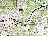
![Our journey]() Topo of our path.
Topo of our path.
For further information, use the National Geographic map #140 (Weminuche Wilderness) or contact the Rangers Office at:
Creede Ranger District
Rio Grande National Forest
3rd and Creede Avenue
Creede, Colorado 81130
(719)-658-2556


Comments
Post a Comment