
|
|
Area/Range |
|---|---|
|
|
35.56500°N / 81.661°W |
|
|
Hiking |
|
|
Spring, Summer, Fall, Winter |
|
|
2980 ft / 908 m |
|
|
Overview
 Jacob Fork
The South Mountains of North Carolina cover roughly 100,000 acres in McDowell, Burke, Cleveland and Rutherford Counties. They rise rather abruptly from the gently rolling Piedmont region and from a short distance provide a striking profile against the horizon.
As Southern mountain ranges go, they’re not that lofty, with the highest peaks barely scraping 3,000 feet above sea level. (As of this writing, I’m not sure as to the actual highest point in the South Mountains. The park lists it as Benn Knob, which is 2,894 feet; but several other sources state that there is a peak in the range at over 3,100 feet—which I have yet to locate.) These mountains form a distinct and separate range from the Blue Ridge, with which they are often associated. They are of a rather complicated geological tapestry, with some of the higher ridges formed of granite which sometimes exfoliates, resulting in some impressive slides.
Addendum: The highest peak in the park is now Buzzard Roost at 2,980 feet. It's also the highest recognized point in the entire South Mountains range. Within the new addition to the park are a number of peaks higher than Benn Knob.
 Slide.
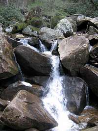
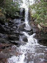
When actually within the interior of the range, one has a completely different impression of these peaks. While they present a stark wall of blue from a distance, a viewer from the peaks sees a broad series of ridgelines broken by very deep, very steep, plunging gorges cut by many streams and small rivers. Some claim that the purest water of any watershed in the state of North Carolina is to be found in the South Mountains, and the sight of these clear, blue-green waters rushing over worn granite boulders and into deep pools certainly seems to echo this claim.

The ridgelines are forested with mainly pines and oaks. However, the coves and streambeds are home to a very lush forest of both Eastern and Carolina hemlocks. Some of the groves in which one hikes in the valleys are sometimes 50% composed of hemlock trees. I hate to keep belaboring this point (and I regret that I feel that I must), but if you wish to see these forests in a healthy state, you had better do so very soon. The Asian pest, hemlock wooly adelgid, now infests pretty much every grove in the park and is beginning to take a toll on the trees there. I would assume that within the next five years these forests are going to be uniformly very sick or completely dead. The state of North Carolina doesn’t seem to be willing (or able) to tackle this problem with the injected form of the adelgicide, so I predict these forests will be extinct by the end of the decade. (As of this edit--03-27-2010, most of the hemlocks in the park and surrounding areas are either already dead or in precipitous decline. The chance to see the hemlock forests in any degree of health has passed.)
 Jacob Fork Gorge.
The South Mountains are unique in North Carolina in that a vast portion of the range finds itself under varying degrees of protection against commercial development. These mountains were pretty much logged over from 1930-1955, but there are pockets of old growth trees here and there (that were in locations from which extraction was too difficult). South Mountains State Park, at over 15,000 acres, is the largest in the state. Half of the park has yet to be opened with developed trails, and so one rarely encounters other people in that section. Another large section of the South Mountains are preserved as game lands, creating (with the state park) a contiguous area of relative wildness of well over 36,000 acres. In addition, the rural areas around these protected lands have yet to be lathered with commercial and real estate development, and so your visit is likely to be pretty quiet and opportunities to find true solitude are ample.
 Unbroken forests.
North Carolina’s South Mountains State Park is the most popular venue for entrance to these peaks. The park infrastructure is based around roads and paths and campgrounds first built by the CCC in the 1930s. Some of the trails in the park are, in fact, roadbeds built by, or improved by, the CCC boys. The park keeps these roads in a high state of repair, and official park vehicles can often be seen on them as the park works to keep them in repair, or to improve campground facilities in the hike-in sections of the park. These wider trails are also open to mountain biking and to horseback riding. In fact, the finest developed campground in the park is reserved exclusively for equestrian users—only they are allowed to use the hot shower facilities in their campground.
 Fly fishing
Fishing is also a popular pastime in the South Mountains. The streams, being so clear and clean and cold, are great habitat for native brook trout. When hiking the trails, you will likely encounter someone fly fishing these creeks and rivers. And there are many deep pools all throughout the range that practically force one to plunge in for a bracing swim. The South Mountains also have a great number of impressive waterfalls and cascades. Almost too many to count. The most well known of these falls is High Shoals Falls, on Jacob Fork. A highly developed trail with bridges and stairs and observation decks takes one up the steep slopes of Jacob Fork Gorge to (and above) this waterfall. However, it’s he most popular trail in the park, so don’t expect to arrive at the falls without seeing lots of other people, even in the middle of the week or in the off-season.
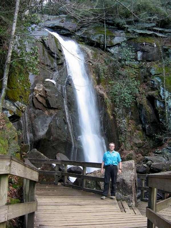 High Shoals Falls
The South Mountains are a unique spot here in North Carolina. Within easy access of the highest population centers in the state, it however remains one of the largest protected mountain areas in the Southeast.
 Falls
FallsGetting There
From I-40 take NC 18 South. Drive for about ten miles (not the nine mentioned in park literature) and make a right onto SR 1913 (Sugarloaf Road). Take SR 1913 to Old NC 18 and turn left. Travel for four miles and make a right turn onto SR 1901 (Ward's Gap Road). Soon see the entrance road to the park SR 1904 (South Mountains Park Avenue).Red Tape
No entrance fee. Backcountry campers must register and pay a fee.External Links
South Mountains Nature ConservancySouth Mountains State Park
Camping
See Red Tape section.Scenery
Friction rock Exfoliated rock
 Summit rock
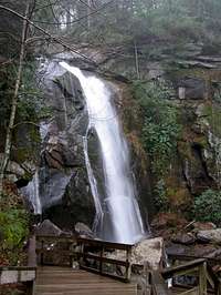 Falling water
 Clean waterWater, water