|
|
Route |
|---|---|
|
|
39.12780°N / 108.7578°W |
|
|
Technical rock climb |
|
|
Half a day |
|
|
A6. Gumbies need not apply. |
|
|
Approach
From the I-70 exit at Fruita (Exit 19), drive south for 1.5 miles to the Kings View Estates and turn right at the sign for McGinnis Canyons Wilderness. Turn right and follow the road for 1.5 miles, before turning left and following the signed road to the trailhead.Route Description
I'm going to tell you how to get to the base of the rock, but I will not give the details of the route up the rock. You will have to work out the problems of the ascent (which are many). Gotta use your thinkin' cap and this aint no climb for sissies.Accessing the climb:
Here is some background on the trails. Most of the trails in the immediate area near the trailhead were created as rough dirt roads for construction equipment by a residential developer. The developer had financial trouble and sold his land to the BLM for a wilderness preserve. Trails were created out of the old roads.
I only mention this to emphasize that there are many trails here, and they can be confusing. It’s a maze of old trails and roads.
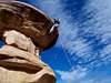
Anyway, the area you want to get to is the minor canyon located east of the large Devils Canyon. Trails are marked with letters and numbers. There are many minor junctions at first, but briefly put, follow trail D1 to a message board sign. A good map is posted on the sign. Shortly after the sign, stay left at D1. Turn left again at K1. From here, make your way to the visible Cowboy Hat Tower (see the Topozone link for location) via one of the following routes:
K1: Stay right on K1 and follow it to a trail blocked off to bikes and horses. Turn left on this trail and follow the trail to the slickrock. Leave the trail and climb along the slickrock to the south and to the Cowboy Hat Tower, doing one minor ledge traverse near the tower.
K8: Stay left on K8 and follow it into the shallow canyon. Stay in the canyon bottom and hike south until Cowboy Hat Tower is visible on the west side of the canyon. Climb the class 3 slickrock up to the base of the tower.
Either route is 1.5 to two miles one way.
Once you are at the base of the tower, find a route and climb it. Using the visible bolt station is cheating, so avoid using it. The Cowboy Hat is an interesting climbing problem, and I add it for your climbing enjoyment and brain power. This climb can take a long time to figure out.
Bolts and pitons would distract from the mostly pristine setting of the climb, so please don’t use them.