
-
 8586 Hits
-
 80.49% Score
-
 12 Votes
|
|
Area/Range |
|---|---|
|
|
48.40735°N / 89.21385°W |
|
|
Hiking, Toprope, Bouldering, Ice Climbing, Mixed, Scrambling, Skiing |
|
|
Overview
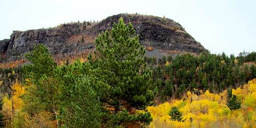 Mt. McKay, Ontario
For centuries, Native Americans and European explorers were inspired to apply the word “Thunder” to the largest bay on northern Lake Superior. The Ojibwe tribe called it “Animalia”, meaning Thunder. French explorers called it “Baie du Tonnerre”, translated Thunder Bay in English. So prevalent is that name for the area, that in 1970 the newly amalgamated cities of Port Arthur and Fort William chose the name Thunder Bay. The harbor is Canada’s westernmost port on the Great Lakes and the 4,680-mile Trans-Canada Highway passes nearby. This page focuses on the area within about an hour’s drive from the bay.
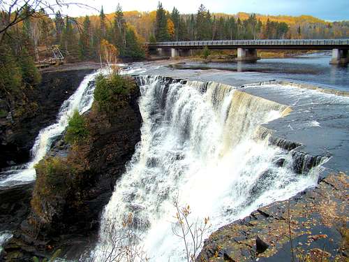
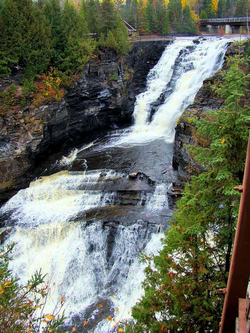 Kakabeka Falls West Channel
The Thunder Bay harbor is bordered on the east by the Sibley Peninsula and Thunder Cape is at the southern tip of that peninsula. The mesas of the peninsula are called the Sleeping Giant because of their shapes that combine to form a “sleeping giant” profile, as viewed from the city of Thunder Bay. The large Sleeping Giant Provincial Park provides what is possibly the best combination of hiking, climbing and camping opportunities in the region. The summit of Sleeping Giant, at 1,847 feet, is over 1,200 feet higher than Lake Superior below, and is the highest summit in the Thunder Bay area.
Other noteworthy features of the area include the Nor’Wester Mountains on the southwest side of the city of Thunder Bay. There are several named summits in the Nor’Westers that offer hiking trails, plus some rock and ice climbing opportunities. Within the Nor’Westers next to Mount McKay is Loch Lomond, a large, deep natural lake. Ouimet Canyon is a beautiful deep canyon northeast of Thunder Bay and offers great hiking and photo ops. For particularly beautiful falls near Thunder Bay, Kakabeka Falls tops the list, though Silver Falls and the High Falls on the Pigeon River are also very scenic and offer additional hiking opportunities. There are many other smaller falls in the area also.
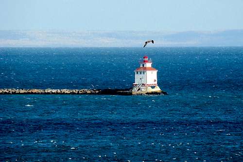 Thunder Bay Lighthouse
The geography of the area around Thunder Bay is characterized by thick forests, lakes, waterfalls, canyons, mountains and numerous streams rushing into the bay and Lake Superior. Metamorphic and igneous rock is everywhere, typical of the Canadian Shield, along with some types of shale (generally soft and unstable) abundant at various locations. The area just north of Thunder Bay is one of the few places in the world where amethyst is found in noteworthy quantities. This region is one of the most mountainous areas of Ontario.
Animal types common in the Thunder Bay area include black bear, gray wolf, fox, Canadian lynx, otter, marten, mink, fisher, moose, deer, beaver, snowshoe hare, vole and ermine. These animals enjoy a forest environment that includes black and white spruce, larch, cedar, balsam fir and jackpine. There are also hardwoods that include varieties of maple, birch, aspen and balsam poplar.
Thunder Bay Area Rock & Ice Climbing
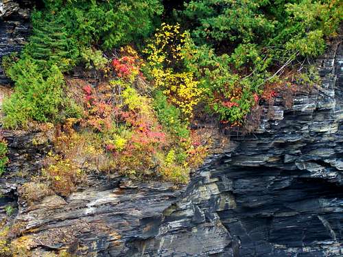 Kaministiquia River Gorge Loose Shale
Granite and basalt rock crags and cliffs in the Thunder Bay area have provided a good foundation for the continuing development of rock climbing opportunities. The many waterfalls and springs in the region also help provide winter ice climbing opportunities. The links below do not provide an exhaustive list of every area rock climbing opportunity, but they do cover a majority of the established routes.
Mountain Project rock climbing listings:
The Bluffs Scenic Lookout, at Centennial Park in Thunder Bay
Mt. McRae Ice & Mixed Climbing Routes
More rock & ice climbing information sites for the Thunder Bay area:
The Crag Climbing Route Listings for Thunder Bay Region
The Crag Sleeping Giant Routes
Northwest Ontario Climbing Routes
Thunder Bay Rock & Ice Climbing Guide
YouTube Rock Climbing Views near Thunder Bay
Sleeping Giant Hiking, Scrambling & Bouldering
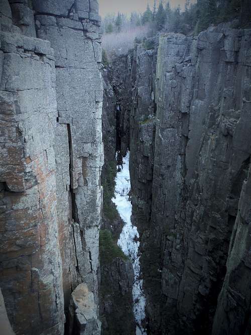 Chimney Canyon
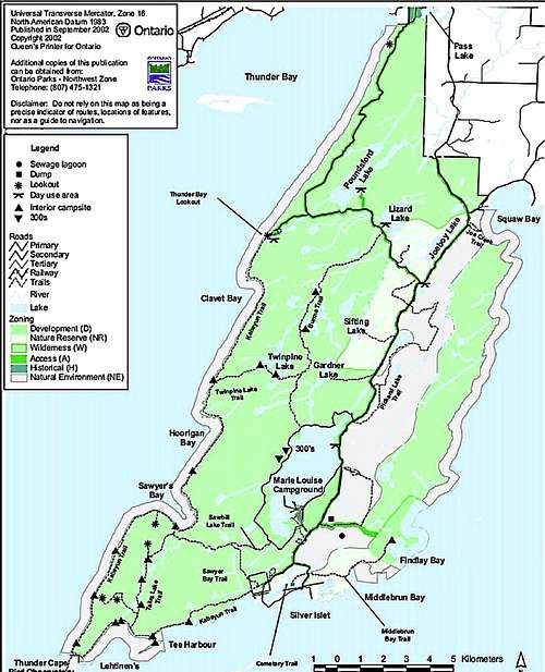 Sleeping Giant Provincial Park Map, courtesy Ontario Parks
Photo, right, is courtesy of Stu Brandel.
Besides the rock climbing opportunities posted in the links above, Sleeping Giant Provincial Park offers many great hiking trails and scrambling locations in its 94-square mile area. Some of the best hiking routes in the park include Talus Lake, Top of the Giant, Middlebrun Bay, Sifting Lake and Sawyer Bay trails. The Kabeyun Trail is strenuous and the park’s longest trail. All the trails offer great scenery and something unique to see.
The Top of the Giant Trail takes hiker-scramblers to a spectacular view of Chimney Canyon, or Chimney Lookout. The canyon itself once had a trail, but park officials have closed off access, due to deadly and unstable rock walls. To reach the actual highpoint of Sleeping Giant, you will have to bushwhack from the trail. The links below provide a wealth of details for those who would like to know more about Sleeping Giant hiking and scrambling:
Sleeping Giant Provincial Park Trails Guide
Superior Trails Sleeping Giant Park Trails Overview
Sleeping Giant Trip Report on SummitPost
Nor'Wester Mountains
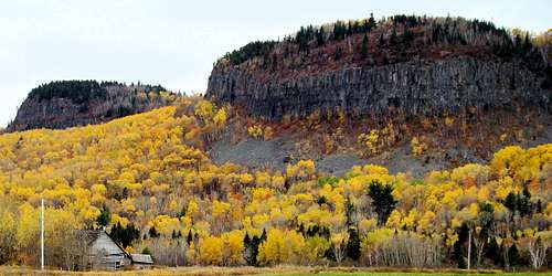 Nor'Wester Mountains, Ontario
A small mountain range is located beginning at the southwest side of the city of Thunder Bay and extends southwestward toward Lake Superior. The Kaministiquia River defines the northern limit of the Nor’Westers. The high point of the range, at 1,585 feet, is Mt. McKay, which rises 985 feet above Lake Superior to dominate the southern skyline of the city of Thunder Bay. It is often called the “Thunder Mountain” of the bay area (though there is also a Thunder Mountain at Sleeping Giant Park). While there are hiking trails on Mt. McKay, the northern vertical cliffs have prompted officials to close some access along that side due to the crumbling rock that keeps the cliffs vertical, but unstable. The Ojibwe Native American Tribe uses the mountain for sacred purposes on special occasions. The name “McKay” for the mountain originally came from William Mackay, a Scottish trader in the Thunder Bay area in the mid-1800s. For a Mt. McKay hiking map and more information, click on the link below:
Other noteworthy mountains in the Nor’Westers include Matchett, McRae, Godfrey, Hurlburt, Johnson, Rose, McQuaig and Squaretop. Loch Lomond is 942 feet above sea level and gathers most of the runoff in the mountains, which is then drained by the Lomond River into Lake Superior. The Loch Lomond Ski Area is northwest of the lake. For more information and maps for Nor’Westers hiking, visit the Superior Hiking websites below:
Kakabeka Falls Provincial Park
 Kakabeka Falls Ontario
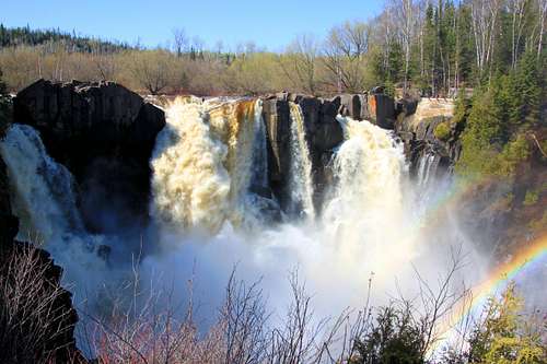
In a region with abundant beautiful waterfalls, having the distinction of being called “the Niagara Falls of the North” is quite a compliment. On the Kaministiquia River downstream from Silver Falls, Kakabeka Falls is the centerpiece of the provincial park that bears its name. The name Kakabeka comes from an Ojibwe word meaning “waterfall over a cliff”. The 130-foot high waterfall draws many visitors every year.
Located about 20 miles west of Thunder Bay along the Trans-Canada Highway, the falls were the reason for developing a portage in the 1800’s. The falls go over a layer of chert, which resists erosion better than the shale underneath. This has caused the falls to slowly move upstream as the underlying shales crumble, forcing the chert to break away when the support is gone. The crumbly nature of the rock in the gorge below the falls has caused officials to cut off hiking and climbing in much of the canyon.
Kakabeka Falls Provincial Park boasts a number of hiking trails, several which are also groomed as ski trails in the winter. Poplar Point Trail may be the most popular trail in the park. The variety of park trails range from very easy to difficult. A few of the trails provide spectacular views of the falls and gorge, while other are forest trails. For trail details, you can download the official maps below:
Ouimet Canyon Provincial Park

Ouimet Canyon is a large gorge with dramatic vertical rock walls over 300 feet high. The volcanic rock has made a pronounced pattern of vertical jointing, giving the rock a columnlike appearance. The canyon floor has a different climate than the rest of the region, due to the short exposure of sunlight. The canyon floor climate is arctic and sub-arctic. Hiking is allowed only along the canyon rim on a short trail system to two lookout platforms. Because of the delicate nature of the arctic plant life on the canyon floor, no rock climbing is allowed in the canyon. However, the nearby Dorion Tower does offer some excellent climbing. For additional information about Ouimet Canyon and park, click on the link below:
Photo above is a public domain photo.
Pigeon River Provincial Park
 High Falls on the Pigeon River
The Pigeon River Provincial Park is about an hour’s drive southwest of Thunder Bay on Highway 61. The provincial park lies just across the river from the Grand Portage State Park in Minnesota. The feature attraction on this river and both parks is the High Falls, approximately 120 feet high. The falls lie mostly in Minnesota, but the river is the border between Canada and the United States. The Middle Falls that are just up the river are approximately 20 feet high. The trails to the High Falls and the Middle Falls are the most popular trails in the park.
Photo, left, is courtesy of cedarbend.
The southern end of this day-use park, next to Lake Superior, offers scenic views of the USA shoreline. Just a few miles across the border from Pigeon River Provincial Park, is Mount Josephine, a worthwhile summit if you have the time and don’t mind the risk of a long wait at the border. For more details on the provincial park, or to download a park map, click on the appropriate link below:
Pigeon River Provincial Park Map
Silver Falls Provincial Park
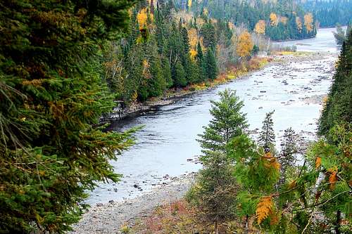 Kaministiquia River Valley
Silver Falls is a very scenic area that is off the beaten path, about an hour’s drive from Thunder Bay. Silver Falls, the highlight of the provincial park, is actually a series of falls on the Kaministiquia River. This provincial park contains great hiking and walking trails and remains one of the classic hiking areas in the Thunder Bay area. Photo ops for the falls and wildlife are another great aspect of this area, as well as camping opportunities. For more information about what the provincial park has to offer, you can access their website at this link:
Red Tape
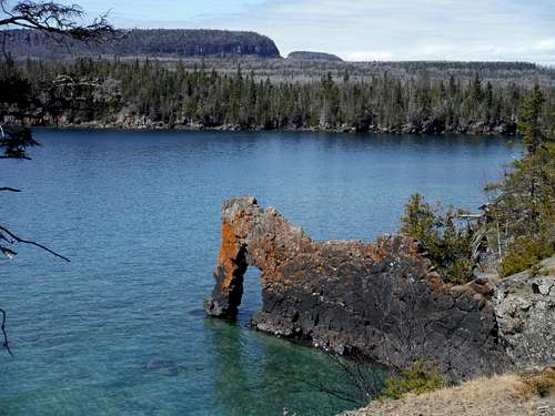 The Sea Lion
Nearly all public access to climbing and hiking in the Thunder Bay area is governed by the Ontario government agencies. Here is a link that provides guidelines on what to expect:
Ontario Provincial Parks Rules & Guidelines
Though you expect to pay park entry fees and campground fees, you might also be wondering what things could earn a person a fine while they are there. Activities that will get a visitor into trouble would include alcohol violations, excessive noise, feeding animals, littering, parking violations, traffic violations, pet violations, campfire and firewood violations, fireworks and failure to observe posted hours of park closures. Some of these rules vary from park to park, so be sure to check out the links provided on this page, or call ahead.
Photo at left is courtesy of Stu Brandel.
How to Get There
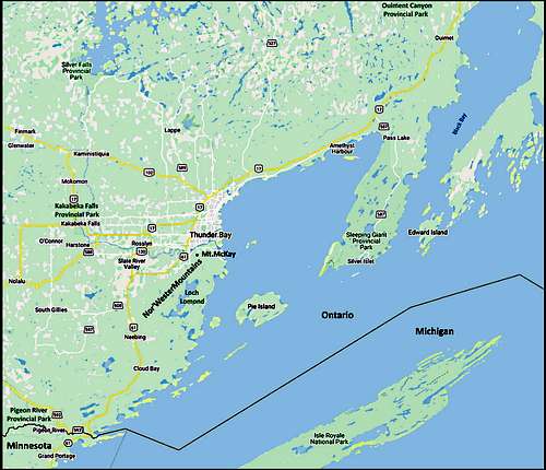 Thunder Bay Area Map
While the Thunder Bay area has much to offer climbers and hikers, the relatively sparse population of the surrounding area keeps it from being overcrowded. The closest major metro areas are Winnipeg, Manitoba and the Twin Cities in Minnesota, each about seven hour’s drive from the bay area. This page covers most of the climbing and hiking opportunities within an hour of Thunder Bay. The Trans-Canada Highway is the core of most road trips into the area, though Highway 61 from Duluth also brings in a significant flow of traffic, especially in the summer and fall.
Air service is available at the city of Thunder Bay (around 120,000 residents), as it is a regional center for medicine, education, commerce and transportation. The map on this page will give you an idea of where everything is located relative to Thunder Bay.
Map at right is courtesy of Google Maps.
When to Visit
Because of the influence of Lake Superior and the northern latitude, weather conditions can change quickly and dramatically. Planning and awareness are essential. Hiking and climbing is popular during warm weather months, and even continues over into winter a bit. However, during winter, ice climbing, skiing and snowshoeing become the most popular activities. For more about Thunder Bay area weather, click on the weather link below:
Thunder Bay Area Weather Conditions & Forecast
Camping & Lodging
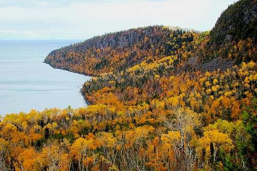 Lake Superior Shore View Looking South
Ontario Provincial Parks Camping Rules & Regulations
Sleeping Giant Provincial Park Camping
Sleeping Giant Campground is about a 70-minute drive around the bay from the city of Thunder Bay. You can reach them by phone at: 1-807-977-2526 For more information on their campground, check out this link:
Kakabeka Falls Provincial Park Camping
The falls are about 25 minutes west of Thunder Bay and the park has three campgrounds. To make reservations, call 1-888-668-7275. Check out their website on the link below:
Silver Falls Provincial Park Camping
Silver Falls are a 60-minute drive northwest of Thunder Bay. For more information, you can visit their website at this link:
For up-to-date information on lodging in the Thunder Bay area: check out this link:
GMJ - Feb 20, 2020 11:45 am - Voted 10/10
Unfinished sentence?The "Getting there" section includes the sentence "Since this page covers most of the climbing and hiking opportunities within an hour of Thunder Bay." I assume this is a mistake? Great page by the way.
scramblingbadger - Feb 20, 2020 3:58 pm - Hasn't voted
Re: Unfinished sentence?Thanks for bringing this to my attention. Since it has been awhile since I wrote this, I'm not quite sure where I was originally going with that, but have changed it to be a simple statement. Glad you like the overall content of the page!