Account of Events
Prelude: Every time I hiked in the Baldy area in recent weeks, which actually was quite often, I was tempted by the ridge leading from Thunder Mountain directly down to the Icehouse Canyon parking lot. That ridge is the southwestern boundary of Cedar Canyon in the Cucamonga Wilderness. The desire to attempt that ridge grew every time I was out there. The sheer numbers are not terribly awe-striking (about 2.5 miles with 3,500 feet of elevation difference) and the summit of Thunder Mountain represents not quite a highlight in the San Gabriel Mountains. However, looking at the ridge from the Register Ridge or from the 3T’s trail one has to admit that it is beautiful. I guess the fact that I could not find any trip reports describing the ascent on that ridge in its entirety certainly fueled my desire even more. On the other side the lack of any reports were also a bit concerning. There had to be a reason for that.
![Steep Thunder Ridge]() Steep terrain from the Icehouse Canyon parking lot to Thunder Ridge
Steep terrain from the Icehouse Canyon parking lot to Thunder Ridge After the recent storm covered the higher peaks in the Baldy area with snow I decided to finally give it a try on the Thanksgiving weekend. I thought in order to have enough time to find my way up the ridge I should start early. Well, not exactly an alpine start but I was at the Icehouse Canyon parking lot at about 8 am on a crisp and sunny day. The plan was fairly simple: climb up the steep slope from the parking lot and gain access to the ridge; then follow the ridge over many bumps to the summit of Thunder Mountain. I guess I haven’t thought about the return in much detail but that did not worry me. There were many options: going down to Baldy Notch and Manker’s Flat and hitch a ride back to Icehouse Canyon or walk down the road to the car, or turn back and take the ridge down. I also was very well aware of the fact that the chances were considerably high that I couldn’t finish the ridge on my first attempt. I virtually had no idea what to expect. I was prepared as well as I could though. I always try to get familiar with the terrain before the hike by studying maps and spending hours on Google Earth. In any case I knew where I was going.
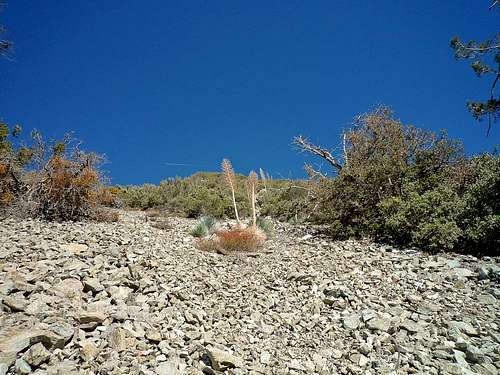
![Another perfect example...]() Typical terrain on Thunder Ridge with loose scree and thick bushes
Typical terrain on Thunder Ridge with loose scree and thick bushes The first decision I had to make was where I should try to gain access to the ridge from the parking lot. I looked up the steep scree slope right behind the west side of the parking lot (close to the road up to Manker’s Flat). It did not look tempting but I was so eager and full of energy that I threw away all concerns. I marked the parking lot (~5,000’) on my GPS and off I went. The route up was very easy to follow; straight up the scree until you hit the first bushes and bigger rocks. The steepness (up to 40% grade) and loose scree did not make it very easy. I had to be very careful not to turn my ankle or to get hit by some of the rocks which I invariably knocked loose. It was strenuous with sliding back on the loose rocks at every step I took. Eventually, after about 150 feet of elevation gain you hit the first bushes and some bigger rocks. Now the navigation through all the beloved and plentiful buckthorn bushes and yuccas started. Often times I had to go back and forth, left and right before I found a way that seemed passable. Beside the bushes there were often bigger rocks that required some easy and fun climbing (class 2-3). Unfortunately, between the fun climbing sections there were always loose scree slopes which drained my energy rather rapidly. Eventually after about 0.4 miles and more than 800 feet of elevation gain (average grade: 45%) I reached the ridge and was really hoping for easier travel. The view now opened up a bit and I could see the ridge leading up fairly steeply in front of me. However, very soon it was back to navigating through thick and thorny brush and loose rocks on a still steep ridge. Making very slow progress I started to realize that I most likely was not going to go all the way up to Thunder Mountain that day. So, I was trying to memorize some distinctive objects, e.g. burnt tree stumps, which may guide me on the way back down. Of course I also saved some waypoints on my GPS. Eventually, after more than two hours and 1,300 feet of elevation gain (in less than 0.7 miles) I reached a point where there was simply no way up. I was in a dead end surrounded by impassable buckthorn, manzanitas, and yuccas. Having already made up my mind to go back I was looking for an alternative route up for another day. After going back down I saw a little bit to the east another small ridge that did not seem to go down all the way to Icehouse Canyon. However, that small ridge seemed to lead further up as there were fewer bushes and more rocks. I later found out that starting from Icehouse Canyon there are a few more or less prominent ridges leading up and eventually converging to the final common ridge (at about 7,100 feet) that goes all the way to Thunder Mountain. Looking east at that small ridge I noticed that I would need to traverse a small but steep gully to gain access to the other ridge. Although I did not explore it further it seemed that that part would require some easy climbing. Since it was still relatively early I decided once I was down at Icehouse Canyon to hike up to Cedar Glen to check out possible access routes up to Thunder Ridge from Cedar Canyon. Going down was easier said than done though. There were so many instances where I just did not remember what path I took up. Luckily I was able to trace my steps back following the recorded track on my GPS. That was one of only a few times so far that I really needed my GPS. Navigation on that ridge/slope is seriously not easy. Eventually, after about 4 hours I was back at the parking lot. I was not frustrated by any means that I could not go all the way. I was actually very enthusiastic about having to explore that ridge more often before attempting it in its entirety. I felt that it will certainly add to the fun and challenge.
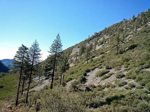
![Possible access to Thunder Ridge]() Possible routes up to Thunder Ridge from Cedar Canyon
Possible routes up to Thunder Ridge from Cedar Canyon After cross-country navigation through thick bushes on steep scree slopes, the way from Icehouse Canyon to Cedar Glen (about 2.3 miles one way with 1,650 feet of elevation gain) felt very relaxing. I noticed that I have never taken the Chapman Trail before. I have to say it is beautiful with much fewer people and great views south over Icehouse Canyon and its impressive south wall. I was absolutely amazed by how steep Falling Rock Canyon and the gully leading directly west up to the false summit of Sugarloaf Peak looked. I simply could not believe that I and a few hiking buddies did that a few weeks ago. I felt good. Cedar Canyon is absolutely lovely. The views to the Thunder Ridge are unobstructed from Cedar Glen. There are certainly several options to gain access from Cedar Canyon to the final ridge. But none of them looked easy. They all will involve a steep climb over loose terrain. There are definitely more bushes on the more southwestern approaches. Studying the ridgeline all the way to Thunder Mountain I realized that about two bumps south of the summit of Thunder Mountain there seem to be a few large rock formations on the ridge. It was obviously difficult to judge from my standpoint but I would not be surprised if that part required some more serious climbing. Sitting on Cedar Glen with the early afternoon sun in my face I was contemplating about what to do next with that ridge. There are actually two things I want to do in the upcoming weeks: Exploring the ridge from the summit of Thunder Mountain going down. That would allow me to check out the rock formations on the ridge. And second to hike up to Cedar Glen and find access to the ridge from Cedar Canyon. That would allow me to explore at least the mid portion of the ridge. Hopefully after I did all the explorations I will be able to put the pieces together and climb the ridge all the way from Icehouse Canyon to Thunder Mountain. While sitting in the sun at Cedar Glen I also thought of some other very nice trips in that area, e.g. going all the way up Cedar Canyon up to the 3T’s trail or to attempt climbing the unnamed peak southwest of Telegraph Peak on one of its ridges. So I guess the next weeks are already mapped out. Hopefully the weather permits to do all that in dry conditions. Attempting the ridge with snow and ice is certainly a completely different challenge. Thinking about how beautiful the sunset must look like from Cedar Glen looking west I headed back and returned to the car at around 3pm with my head full of new ideas. Today’s exploration totaled to about 6.4 miles with 3,200 feet of total elevation gain.
Disclaimer: The track was recorded on a Garmin GPSmap 60CSx with coordinate savings every 30 seconds. Mileage- and elevation readings were calculated after importing the gpx file into National Geographic’s Topo 4.0 software. Below is a Google Earth Rendition of the described hike.


Comments
Post a Comment