Boulder Pass, Hole in the Wall, Brown's Pass
The Boulder Pass, Hole in the Wall, and Brown's Pass areas are quite popular in Glacier National Park and with good reason. They offer some staggering remote beauty, pristine and without the fire damage and automobile clogging that have ruined some of Glacier National Park for the present day. Going in early summer avoids the crowds and makes for more fun for the sporting fit kind. What is normally a scenic walk becomes a bit more challenging, and you can get all the isolation and privacy a man can stomach. The season for Hole in the Wall Campground for example is about August 1 through mid September- very short, and certain to be crowded. This was a trip taken in early July, when snow angles and cornice actually prevented rangers from visiting the Boulder Pass area (due to park safety regulations). Thus, I had a big beautiful corner of the world all to myself.
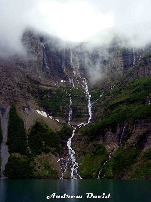
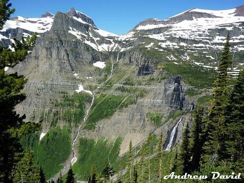
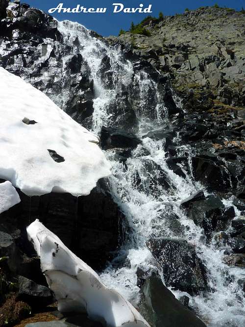
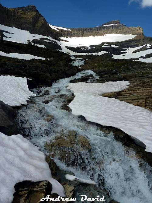
![Frances Lake GNP]() Waterfall during a lull in heavy storms.
Waterfall during a lull in heavy storms.
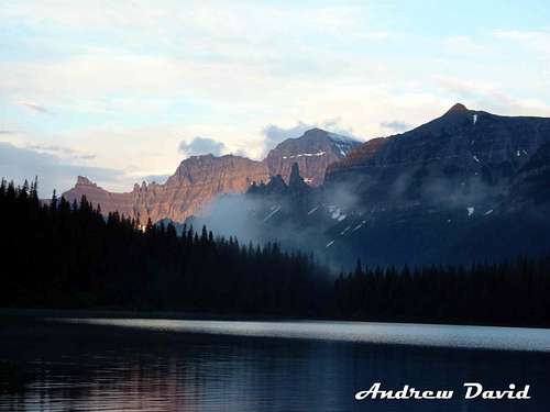
| ![Frances Lake GNP 2]() Mt Cleveland alpine glow from Lake Frances.
Mt Cleveland alpine glow from Lake Frances.
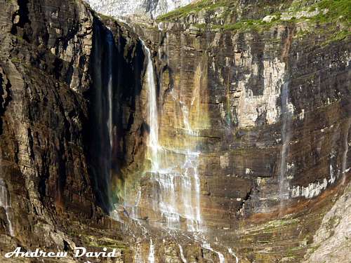
| ![Frances GNP 3]() Rainbow in the morning on the falls.
Rainbow in the morning on the falls.
|
I will spare you most of the details as I doubt anyone cares much about my inner feelings and blah blah blah, and the pictures can tell the story and there are guide books out there if you can't follow a trail for yourself. But here are some basics. Brown's Pass is the logical basecamp when looking at maps if you are targeting several peaks in the NW area of GNP. There are several noteworthy peaks all within a day trip of the spot: Thunderbird Mountain, Boulder Peak, Custer Peak, Chapman Peak, the unnamed pyramid 9125, and Guardhouse and Sentinel. I may be forgetting some. Thus, Brown's Pass is where I signed on to spend 2 nights. You can reach this campground either from a 14 mile approach to the West (and in America), after hours on dirt roads. I cannot speak to this, though I hear it is charming in its ways. The shorter approach and probably more attractive walk starts from Canada, and includes the grievances of border patrols. I have never met such ferocious snarling beasts as one will with Canadian border patrol. I have heard this from others as well. They are just a strange, bored, over-zealous sort of red-tape loving jerk. But after a few rude questions and sneers and after you have been let know in a general way that the fine nation of the Maple Leaf and the glacier hates your guts and considers you some form of inferior sub-life, and that they only take your tourism and money begrudgintly, and after paying for an entry ticket to Waterton, then for a slow, expensive, chatty, crowded boat ride, and getting back into America, you only have 8 miles to go, with campgrounds, lakes, and breaks all along the way. It is a truly fine walk! And Waterton is a great place to buy some crap you will never care about once you are back home, and to eat decent food, (which I hear you can find in Polebridge, MT as well- near Bowman Lake where the 14 mile approach starts).
As I stepped off the boat, huge thunder and lightning rent the air, which I found charming as I was going to Thunderbird Mountain, for a wild and dangerous adventure. Or so the guide books suggest it will be. This was less charming when it began to pour a few minutes into my 8 mile walk. Waterproof boots are amazing, unless they get wet inside from rain streaming down your soaked pants and socks, and wet overhanging plants brushing you with every step, at which point you are in poor shape, as they take forever to dry out. I met a cool guy from Seattle and rather than press on in the storm, I tented up with him at his reserved campsite near Francis Lake. The waterfall was remarkable in the storm. And luckily I had an ice axe which we could dig trenches with, because there were rivers of mud and sludge threatening our joy of life. The night was cold and long, but we and another camper hit it off and passed time easily, with a nice alpine glow and sun in the morning. We went on together to Brown's Pass where we learned that Brown's Pass is probably the buggiest and worst spot on earth. It is impossible to be anywhere near that campground without having thousands of mosquitoes crawl all over you. It is maddening and disgusting, and these pests laugh at DEET. They bite you anyway, dying in mid gulp of blood. Seriously, they just sort of freeze in the pose of the vampire and then you brush them in a smear off your body. As I only brought a bivy sack, this was a concern.
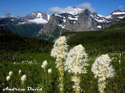
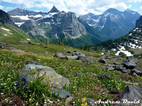
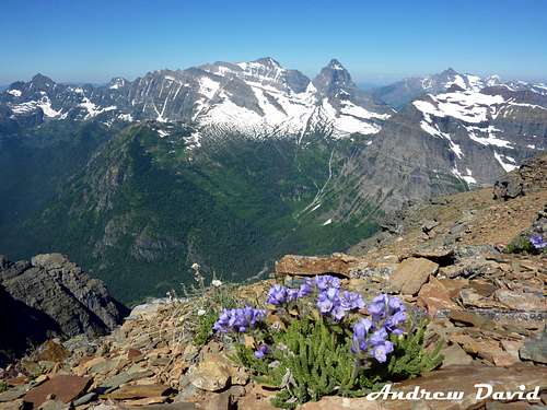
![Hole In the Wall 1]() Bear Grass with Boulder Peak behind.
Bear Grass with Boulder Peak behind.
| ![Hole in the Wall 2]() Hole in the Wall and Boulder Peak
Hole in the Wall and Boulder Peak
| ![Hole in the Wall 3]() Starting on the tricky portions
Starting on the tricky portions
|
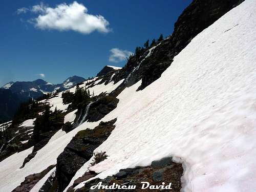
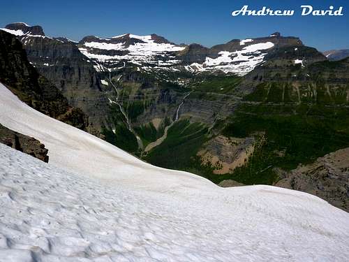
My friends went their own ways and in wet boots I headed up toward Hole in the Wall on a cold morning. The scenery becomes awe-inspiring a mere 10 minutes away from hideous, burned, buggy Brown's Pass. My friends should have tagged along for the great easy to obtain view. I think it changed my life. I only exaggerate all the time, by the way. Meadows and bear grass opened up with swirling clouds and blue skies. I made the vain effort to dry my boots and got the rest of me warmed in the sun on a fine rock, lunching. Snow was still thick in many areas, blocking and masking the beautiful trail cut into the side of the sweeping slopes. But the way to Boulder Peak is evident and intuitive. I met no animals surprisingly as usually when solo, one cannot beat the goats and bears and sheep off with a stick in GNP. And of course, I met no other hikers as the area was listed as "winter condition". I think the snow added some unique beauty, as did the melt falls cascading all around me. The footing was treacherous at times, and in July, one certainly needs axe and crampons to attempt going to Boulder Pass. The real difficulty though was having wet feet and putting crampons on and off about 12 times up and down.
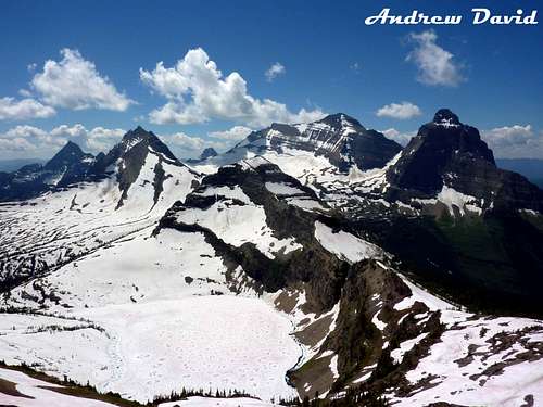
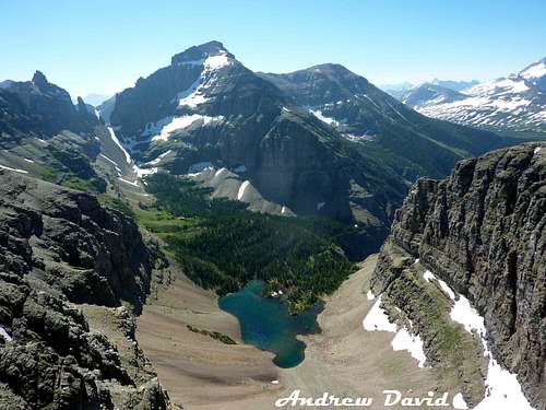
Boulder Peak is normally a walk only so the snow makes it more interesting as a "challenge", but it is still simple. I don't think there is such a thing as a "best view" in GNP, this one is up there as being as good as a view can be. The 360 is remarkable and I made several sweeping movies, hoping they would turn out as the snowglare even through sunglasses was blinding. I am keeping these to myself and Facebook. Pocket Lake with Kinnerly and Kintla behind is what I went up to take in, and sadly Pocket Lake was almost invisible beneath snow still, not filled with icebergs as I had hoped. But oh well. The view of Thunderbird Mountain and the big pyramid just East of it (unnamed) is very admirable. I have thought since first viewing it that Thunderbird Peak is one of the finest mountains in America. It is just what a mountain SHOULD look like. Custer Peak had to wait another day as I worried about leaving my boots on too long and about light or legs running out. So it was back to Brown's Pass to be miserable with some other campers. I got back way too early unfortunately. Bed by 7pm anyone? I will mention here one can winter camp in a group of up to 6 at Boulder Pass, and that there is plenty of water by mid June to collect without resorting to melting snow, most years. There are very few bugs and excellent views!
| ![Boulder Peak 1]() Pocket Lake, Kinnerly and Kintla, looking West from Boulder Peak
Pocket Lake, Kinnerly and Kintla, looking West from Boulder Peak
|
|
Next day I targeted Thunderbird Mountain, a zigzag ascent that would make a drunken goat proud and which is far from intuitive, with a bit of everything: bushwhack, scramble, glacier, goat trail, climbing, route finding, and more. The Edwards Guide suggested staying just under some black cliffs as I worked my way East and around the hump peak looking for an opening. He and I apparently differ in what "just below" means, as I got into trouble quickly, then descended 100 ft and had much better luck. The forest bushwhack is creepy as it feels every moment some grizzly will maul you. No one goes back there. It took a rough hour to find an opening in the cliffs up to Thunderbird Glacier and like a fool, I did not mark it when I reached snow, as I presumed I could just follow my crampon tracks back to the spot later that day. We'll come back to this thought. The Glacier is surprisingly simple- crevasse free this early in summer, and with a slope less precipitous than it appeared below. A slide will mean a 4 second fall to your death though, if you don't catch yourself in time. The way to the shoulder described in the Edwards book is obvious. From the shoulder, the goat trail is also obvious. Keep just against the vertical cliffs and head due South and there is no way to go wrong. Early summer, you will need axe and crampons and will be in and out of them repeatedly. This made the going tedious. A number of coulours and breaks in the cliffs tempt, but I suggest heading to the SW shoulder where you will get a striking view of a very secluded lake.
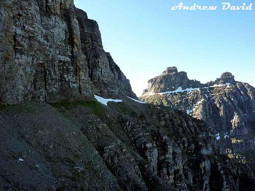
![Hole in the Wall 5]() Thunderbird Mountain, magnificent from Hole in the wall Cirque. Notice the amazing potential May route up the snowy coulour on the North face of the peak. Trad route goes around the "hump" then traverses the Thunderbird Glacier, follows a goat trail to South of the peak and up. (The true summit is not visible, but sits just behind that in the photo).
Thunderbird Mountain, magnificent from Hole in the wall Cirque. Notice the amazing potential May route up the snowy coulour on the North face of the peak. Trad route goes around the "hump" then traverses the Thunderbird Glacier, follows a goat trail to South of the peak and up. (The true summit is not visible, but sits just behind that in the photo).
| ![Thunderbird 1]() Goat trail along the West of Thunderbird Mountain. Just hug the wall. No trick to it.
Goat trail along the West of Thunderbird Mountain. Just hug the wall. No trick to it.
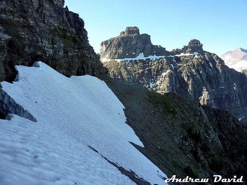
| ![Thunderbird 2]() Snow/ice on goat trail. Okay I guess these are tricky.
Snow/ice on goat trail. Okay I guess these are tricky.
|
From there, you have 3 coulours near. 2 are on the South "face" of Thunderbird, and 1 was passed along the West face. I actually think the one on the West is easiest and most direct, and of the 2 on the South, the one nearest the SW corner is far better than the one farther. I played in all of them. There may be other options further along, but as I was alone and the snow patches were dangerous and tedious and it was getting late and my feet were still wet from 2 days before, I didn't press on. Originally, I'd hoped to hit Jefferson Pass and make a big grand loop, but that route is not going to be fun or exciting for solo trips. Take friends, plan on suffering, and go a little later in summer, near August when the lingering steep snow won't add hours to your miles. The way to Thunderbird summit is anti-climactic, as are the views. But I guess after wanting a peak for 5 years and finally getting there, that is normal to feel. And I am glad I did it. The climbing is 3rd class I guess, but a treacherous 3rd if you pick one of the harder coulours.
![Thunderbird 3]() When you get this view, pick one of the nearest coulours- whichever looks most fun, I guess.
When you get this view, pick one of the nearest coulours- whichever looks most fun, I guess.
| ![Thunderbird 4]() Taken from the SW shoulder, which I thought was a better view than the true summit.
Taken from the SW shoulder, which I thought was a better view than the true summit.
| ![Thunderbird 5]() Greetings from the Thunderbird Glacier.
Greetings from the Thunderbird Glacier.
|
The Edwards book mentions a fantastic windy campsite on the shoulder over Thunderbird Glacier, and it would be astonishing to wake up there, but I'm far more preferential to that SW shoulder. I think the view improves and if you are going to lug a pack up anyway, you may as well drag it to that second shoulder on the first night. The goat trail is level and only a mile or a mile and a half of travel. You would need to melt snow for water at either spot.
Descent was slow again thanks to the ice and snow patches, and then I was trapped on the Thunderbird Glacier for close to an hour as the sun had completely hidden my tracks by melting- a thing I had never supposed could happen. I went back and forth looking for where I'd come up, finally thinking of that ancient mountaineer's trick: checking the digital camera to review pics from the ascent. That helped. Got lost a couple other times on the trip back to Brown's Pass, in the sense that I did not go the way I'd come, and I found some bad spots for a human to pass. I did not tarry at Brown's Pass. It is nearly impossible to eat there. Met a ranger who seemed astonished anyone would go up Thunderbird Mountain and quite curious how one would even do the thing. I speculated 5 parties go up there each year perhaps, and the ranger was of the opinion it is more like 2. So that does make a body feel special. I admitted that after 7 hours of work, and all the miles one covers when the thing seems to be just towering right over you, it probably wasn't worth it, really. But still, as I say, I am glad I did it and can stop sighing over having never done it. It is a unique challenge. Unfortunately, I had to get over to Kootenai Lakes by dark if I were going to honor my permit.
![Kootenai 1]() My view while convalescing for a day and some change.
My view while convalescing for a day and some change.
This was one of my many bad ideas I get every summer: climbing a peak and then hiking 12 miles by nightfall. I made it, but my feet were ruined by the time I did. I got trench foot, or jungle rot or whatever you know it by, and that takes months to heal all the way. It is not fun. Had I stopped and camped at Francis Lake or one of the other lakes in that string of campgrounds, maybe I could have avoided that trouble and just have had good old run-of-the-mill blisters. But I did play by the rules and camped where the permit said, even in an empty park on a Wednesday night, and Kootenai is a decent place to malinger with wrecked "wheels". No hope for some other peaks I wanted that week though. I hope this was of some use to someone. It is a fine place to go.


Comments
Post a Comment