Tom’s alarm went off at five while rain hit our tent, as it had on several mornings before. In those first few moments between vivid altitude-induced o-so-pleasurable dreams and the first disgruntled grunts of waking my first thoughts were of utter disappointment- I had been looking forward to this day for the past week. When Tom reacted to the morning with eagerness, I was confused and somewhat annoyed that he wasn’t as disappointed as I was. There would be no quest, just a cold and wet, unpleasant descent back down the mule track to Imlil. Yet wasn’t Tom no fan of Rain either? It was then that I realised that I was in fact hearing the light breezes of dawn. My Bavarian friend had peaked out of the tent to see beautiful clear skies outlined by dark mountain ridges and the sun rising down the valley.
Energized by the beautiful morning, we quickly gathered our few pieces of gear at the tents and moved up to the refuge where the rest of our kit was being stored, sharing farewells with the early risers of our team. We packed our rucksacks, weighing in at around fifteen kilos each, while watching sleepy Berbers leave the refuge, preparing to lead their tourist groups. Armed with a packet of Pringles, several Mars Bars and a symbolic can of Tuna we set off, approximately half an hour later than we had climbed out of the tent, the sun was already significantly higher in sky. It was going to be a hot day.
We were ready to depart on our two day quest, The Toubkal Refuge to Imlil: The Hard Way. A 24km trek beginning with an 800m ascent to a 3700m pass that would look back on Toubkal before descending down into new valleys before climbing back up a final 2400m ridge before the last descent into Imlil.
Our initial route traversed the base of mountains across the valley from Toubkal, above and parallel to the mule track that was the primary route down to Imlil. Finding our way was difficult and hindered by the poor map quality (As an Englishman, I’m spoilt by Ordnance Survey). There was only one pass that would lead us into the next valley; the rest of the ridge formed walls of cliff and high rock buttresses, impassable for the two of us without ropes, climbing gear and additional cans of tuna.
We found the gully that began the ascent up to the pass. Progress however was slow; we were hindered by large patches of thorn bushes with exceptionally sharp razors pointing in all directions, large boulders that littered our path and the steep sides of the gully itself. By the time the sun was hitting us horizontally we had encountered our first obstacle- a large face of about twenty feet in height that stretched across the breadth of the gully. We both moved to opposite ends of the gully to carry out our basic reconnaissance (and to take a leak). We decided to climb up the rivers course and after a simple relay system was established to move the bags we had a short solo climb over small waterfalls.
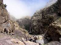
![Member Profile Photo]() Taking my time with the steep scree.
Taking my time with the steep scree.
We were soon able to scramble on upwards, the gully widened and the cliffs continued to rise above us. The rock was almost perfect for climbing, although at times it had a tendency to come away in our hands, it provided plenty of holds and from all angles. We passed two possible escape routes leading to the scree fields above us to our left but they were far from our mind when we found one cairn and then yet another, showing a path climbing above us.
We had to put away our trekking poles as a series of rock steps ascended above us requiring more handwork. Above these steps the terrain became barren and large rock faces rose up on each side of the valley, loose scree in between. The path left the gully moved above the river bed to the right, weaving a path between rock faces and through the scree. I began to struggle up this section, hindered by both a heavy sack and an empty stomach. A small breakfast of Pringles and mints did little to cure my hunger pangs. The final third of the ascent to the 3724m (11,960ft) pass was a torment upon the legs. Having left the gully far below us we found ourselves on very steep scree fields, our view back on them a week later would have us questioning our own decision making abilities. My reflection of the climb a month later however had me eager and determined to try far more demanding routes.
Progress was slow as the slope turned past a final outcrop of rock the pass came into sight at last, possibly just over two hundred feet above us. I’ve experienced my fair share of scree but this last section was a nightmare for me; incredibly loose rock which took me back further with every step that I took. I found a small rocky ledge and used it for support and balance, in places I was a able to scramble across it to keep out of the scree just below, although many of the handholds I had to take left me in exhaustively awkward positions. A true learning experience.
![3700m pass]() Tom at the first pass.
Tom at the first pass.When we finally reached the pass we were rewarded with hard earned and magnificent views. Impressive ridges of rock descended into a thick blanket of cloud that covered all the land below a height of around 2,500m to the far reaches of the vast horizon, a deep blue sky above us. Looking back the way we came gave us impressive views of Jbel Toubkal and the metal pyramid at its summit could be seen silhouetted against the sun.
The other side of the pass appeared to descend rapidly into a second steep and scree field gully, which in fact held a stable and reliable path. We were led down into a small glacier carved and barren scree strewn valley; small patches of snow its only visible occupants covering the small streams below. The path was well defined and remote, with an evident lack of rubbish that normally littered our routes. After crossing two narrow snow fields we reached a second col, at 3656m (11714ft), nestled between a ridge leading to the summit and a vast head of rock that would make excellent climbing if it were not so inaccessible for a single days foray.
My frail but recently recovered nerves were shattered once more as we looked down at the steep drop we had before us. A small basin, once more scree strewn, sat blow us tall cliffs surrounding it, a small path hugged the base of the closest cliff before being lost. At the bottom a bottleneck in the form of a gorge menacingly awaited us, the mouth of Jonah’s whale, its left face a sheer and overhanging cliff, at its tip sat a snowfield hanging at an acute angle. Its right face, to our distress, remained hidden from view. We realised that our path may prove impassable further down, resulting in our defeat and having no choice but to turn back and upwards to the col once more. From there we believed we could attempt to navigate down another valley. We realised much later however, once we returned to Imlil, that this route would have proved fruitless and left us stranded with a long walk back.
![Scree Slopes in the Haut Atlas]() Tom descending back down through scree after our long traverse.
Tom descending back down through scree after our long traverse.Unconvinced but determined to try we started to climb down into the basin and after crossing the top of the scree field we began an ungraceful jog down. By this time I was very timid of scree, my confidence would not return for several days. As the gorge grew beneath us we become more convinced of our error. Halfway down the scree we stopped on a large rock ledge sticking out of the loose rock and I gladly rested while Tom climbed back up, looking for an alternate route. I passed the time by imagining the rock on which I sat coming loose and sliding down along with me still on top into the gorge and further below. When Tom returned with news of there being no alternate route we had no choice but to continue on down, desperate for victory against this unforgiving terrain.
Shortly below the rock on which I had sat and contemplated my dark thoughts we discovered (much to our surprise and joy) a small cairn marking this as a path and not a fools trail. It was a true testimony to our drive to continue until we couldn’t go any further, or at least so it appeared to my adrenaline-overdosed consciousness. We continued downward and soon found a series of small cairns, which each grew in size as we passed them, I was grateful that they led us safely down to the right of the gorge where a solid path materialised.
After forty minutes we had left this gorge and entered into a large valley and were sat by a small stream and were filling our depleted water supplies with clear glacier chilled water, iodine tablets applied for taste! We soon continued down this new valley, rock strewn but green nonetheless- thistles and tufts of grass but still a welcome change to the barren landscape, through which we had been travelling for over seven hours. Passing a shepherds boy, with whom we briefly conversed in broken French, we reached a second refuge sitting at 3000m (9635ft) just below an impressive waterfall. The South Africans which we had met yesterday had warned us that it was likely to be closed however it was bustling with Berbers when we arrived. After we had declined the numerous offers of lodging, tea and cola we sat behind a small building which was undoubtedly the outhouse to enjoy a well deserved lunch, more Pringles but with some chocolate biscuits for added variety.
The time was one o’clock; I remember it well for it was when I lost my hat, which apart from being very effective from keeping off both sun and hail made me feel the part of a young adventurer. As it blew over the precipice that the refuge sat above Tom suggested we could climb down and get it, fatalistic however I knew that it was gone. We continued our trek down the valley; we estimated that we would reach the next refuge in two hours of solid marching, which was enabled by our first solid path of the day. In the midday sun it soon became clear that I needed to cover my head, my only option was to remove my T-shirt and wear my jumper, with a hood instead. The heat was almost unbearable but it was a far better alternative than sunstroke. After about an hour we reached the narrow end of this valley, another gorge but a far more manageable one with a solid path throughout. A patch of shade across the river presented itself and we decided to take an hour’s siesta while we waited for the sun to pass from directly above.
We continued our trek down the valley; we believed that we would reach the next refuge in two hours of solid marching, an estimate enabled by our first solid path of the day. In the midday sun it soon became clear that I needed to cover my head, my only option was to remove my T-shirt and wear my jumper, with a hood instead. The heat was almost unbearable but it was a far better alternative than sunstroke. After about an hour we reached the narrow end of this valley, another gorge but a far more manageable one with a solid path throughout. A patch of shade across the river presented itself and we decided to take an hour’s siesta while we waited for the sun to pass from directly above.
At quarter past three I retied my shoes after having patched up my suffering feet. The sun was by then at a much more bearable angle and therefore a far better temperature. We started to hear the sound of louder water in between our own thoughts. A spectacular 40m waterfall soon came into view; mist creeping up the valley turned this vista into a surreal environment, complemented by small and twisted trees, which sparsely occupied the surrounding slopes. We passed down through the gorge, past a sequence of small waterfalls, lazy rapids and then one larger waterfall offset to the side so that would make an excellent shower in the morning sun. This scene would prove my most vivid recollection afterwards.
![Surreal Waterfall]() Surreal Gorge- quite a contrast form the barren slopes we'd been on.
Surreal Gorge- quite a contrast form the barren slopes we'd been on. We left this surreal scene and entered into the head of what Tom described as The Garden, suggested by the vivid greens and variety of plant life that it held, along with the occasional dead wood tree and interspersed with the occasional large boulder. Below this scene of tranquillity sat a small village, houses made of stone and wood, built directly into the mountainside. The village appeared long abandoned, many of the houses had crumbled inwards and the only occupants appeared to be stray mules that had climbed above the large tourist group we would see below in short time. On investigation Tom discovered a kettle, showing signs of human habitation, unless it had been left to rust or the mules had developed a taste for nettle tea.
Signs of life began to appear as we walked further downwards, an old man sitting by a river- possibly a lonely occupant? A muleteer ran up towards us, either to get to the tourists first, but no straight past to reclaim is grazing animal. We discovered, upon our arrival, that the refuge that we had intended to stay was a misnomer, small shacks surrounded by a sea of identical tents, a large tourist group sat around tables below. We decided immediately after a failed bartering attempt to bring down the price of a single loaf bread from 10dh (4 times its price) that we would not be staying at this trap, we had no tents at any rate and the accommodation was suspect to say the least.
Both tired we continued onto Imlil, our path now led back up hill to a third col of 2490m (7995ft) which required a further 300m (960ft) of ascent. I set a fast pace that was easily sustainable by the gentle nature of the paths ascent and its quality, the best that we were to see in the two weeks spent in Morocco. The path hugged the mountainside and was far further than our Birdseye estimate of distance on the map suggested. We soon saw the same muleteer as before running below us on a parallel mule path with his animal a step behind. Another example of the stamina of the Berber people.
The lack of rubbish again showed us that this was not a tourist path. When we finally reached the col, after an hour and half’s forced march through mist and gnarled trees, we celebrated with the last of the chocolate biscuits. Too exhausted to manage a slower walk I set another knee breaking pace down a mule track through the last scree field of the day. The descent was quick and we reached the first signs of civilisation, a single shepherd’s hut, to the sound of bleating goats and a barking dog. His master greats us by his hut and I once again struggle through French to decline an invitation of lodging and food, we didn’t have the money.
Not realising it at the time but this was the point that we lost our path and as we walked beneath a thick blanket of walnut trees we mistook dried irrigation channels as paths and their crisscrossed routes soon had us lost between a maze of small fields. We decided to follow the river down to Imlil, never a wise decision on most occasions however the river was low and left plenty of room to follow it down. On our final descent we met a man who gave us directions, ‘follow the river’, and was exasperated when we had to be told for the second time. Later we met a small boy and after we had declined further invitations of a nights lodging and a meal directed us in the direction of the road to Imlil. We found ourselves upon the familiar track above our Taxi driver’s home. By eight o’clock we were showered and awaiting food in the hotel opposite the apparently empty and unused refuge in Imlil.
We had condensed our two day trek into fifteen hours and looked forward to a good meal and an early night. We had climbed and walked through spectacular terrain, seen a new aspect of Morocco and experienced the peace and solitude the High Atlas had to offer. Overall, an excellent day.
Comments
No comments posted yet.