
-
 19264 Hits
-
 70.83% Score
-
 1 Votes
|
|
Route |
|---|---|
|
|
45.95000°N / 7.30000°E |
|
|
Hike |
|
|
A few days |
|
|
Walk-up |
|
|
Approach
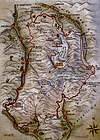
The tour of the Combins is a six laps excursion and the start point is Bourg Saint-Pierre. It is also possible to start from every stop of the tour.
Signs of the tour :
In Switzerland : vertical signs with arrows and yellow shaped signs
In Italy : yellow diamond shaped signs with the lettering TDC.
Route Description
1) Bourg Saint-Pierre - Col de Mille
From Bourg, pass by the Lorette Chapel, Creux de Ma, Boveire d'en bas, Le Coeur, Erra and continue through pasturelands high over the Entremont valley. Night in the Col de Mille Hut, new hut with 40 beds built in 1996.
2) Col de Mille - Pannosière
From the Mille collar, you enter the district of Bagnes, the largest of Switzerland. The itinerary heads N-E and reaches la Treutse after an hour. Continue eastwards among blueberries and pine-woods and reach the Brunet Hut (food available). Walk SE alternatively up and down on a path to reach La Maye where the moraine crest is left to walk down to the old Corbassière Glacier bed. Follow the winding path and reach the footbridge crossing the tumultuous waters escaping from the glacier. Walking up the right bank of the moraine, you join the Fionnay path and the FX Bagnoud Hut at Panossière.
You can also reach the hut over the Avouillons collar by crossing the glacier.
3) Panossière - Chanrion
Climb short but steep to the Otanes collar by walking along the moraine on the right of the glacier. Otanes collar is the highest point of the Combins tour (2870 m). Walk over a stone area in order to reach La Tseumette. After a short descent, the itinerary regains altitude and reaches Pierre à Vire, Lia and Tsesette, where the track passes at the foot of the eastern rampart of the Grand Combin. Descent to the Lancer bridge, cross the Dranse river and climb again to Chanrion Hut.
4) Chanrion - Col Fenêtre - By-Ollomont
From the hut, walk downwards through pasturelands and cross the Grand Charmotane bridge. After a steep climb, the slope becomes more gradual and the route reaches the Fenêtre Durand. Leaving the upper Val de Bagnes, the route continues overlooking the green meadows of Ollomont. The track passes through a stony area, an area full of massive rocks and reaches the pasture land of Thoules. Not far from here, you leave the easy track and continue along the route leading to Farinet house. The hiker will have to walk down the steep path to Ollomon to stay overnight (the huts of By and Champillonare not finished yet)
5) By-Ollomont - Etroubles - Saint Oyen - Saint Rhémy
Reach the Champillon collar, passing through pasturelands.. Descend through the Menouve valley and reach the Pointier valley and the village of Praille. Walk up to Combe Germain and walk along the Eternod stream . Walk in W direction through a beautifull larch-forest to Montagne de Barasson. From here a path joins the forest road going down to Saint Rhémy. Cross the road to get to Etroubles or Saint Oyen, nice places to stay a night.
6) Etroubles (or Saint Oyen, or Saint Rhémy) - Great St Bernard Pass - Bourg Saint Pierre
In Saint Rhémy, follow the main street and the road the the Great St Bernard pass for a short while. Follow then the roman road, cross the main road tvice and continue through the surrounding pastures. You will reach the main road and shortly after, the Great St Bernard collar. The route continue to the Combe des Morts and toward Hospitalet. After the pastures of La Pierre, the tunnel and the Thoules dam appear. Bourg St Pierre is now close.
 |
Essential Gear
Telescopic sticks, trekking boots, warm clothes, food for the excursion.
Maps
Grand Saint Bernard 1:50000 Editions MPA
La Valle des Gran San Bernardo 1:30000 La Traccia
Val de Bagnes - Verbier 1:25000 SD Bagnes
Au Pays du Grand Saint Bernard 1:40000
Huts
Col de Mille Hut + 41 079 221 15 16
Brunet Hut + 40 079 628 49 16
Panossière Hut + 41 027 771 33 22
Chanrion Hut + 41 027 778 12 09