
-
 17070 Hits
-
 74.01% Score
-
 4 Votes
|
|
Trailhead |
|---|---|
|
|
48.31704°N / 113.35762°W |
|
|
Flathead |
|
|
Spring, Summer, Fall, Winter |
|
|
5213 ft / 1589 m |
Overview:
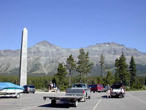 Marias Pass Parking area, the Obelisk and Little Dog and Summit Mountains in Glacier National Park, jimegan photo.
The Autumn Creek Trailhead is a primary access point along the southeastern side of Glacier National Park. Other trailheads include Lubec Lake Trailhead, East Glacier as well as the Fielding/Coal Creek Access.
The Autumn Creek trail can also be accessed west of Marias Pass where Autumn Creek confluences with Bear Creek on U.S. Highway 2. It is 5.6 miles from this trailhead to the Autumn Creek (Marias Pass) Trailhead and has an increased elevation gain to reach Marias Pass. This is a popular trail in the winter for skiers and snowshoers.
Mountains Accessed from this trailhead:
Little Dog Mountain
Summit Mountain
Routes Accessed:
Little Dog Mountain (GNP), Continental Divide Route
Summit Mountain (GNP), Continental Divide Route
Getting to the Trailhead:
 Three Bears Lake from along the trail.
The Autumn Creek Trailhead is located on the southeast side of Glacier National Park. It is easily located due to being located just to the northwest of the large obelisk and statue of John F. Stevens.
John F. Stevens was the engineer who surveyed the route through Marias Pass for the great Northern Railroad. The canyon to the west was named for him to recognize his contribution to the opening of the railroad. The obelisk was originally located in the center of the highway with lanes traveling around it on opposite sides. It was later moved when a rest area was established at the summit.
At an elevation of 5,213 feet Marias Pass crosses the Continental Divide and this portion of the Autumn Creek Trail actually follows the Continental Divide for part of it’s length prior to reaching the junction with The Autumn Creek Trail which travels south of the Divide from near Elk Mountain to East Glacier.
Access the Trail:
 Location to cross the railway tracks.
 Look for this tree with the orange and white markings.
 GNP Trail Sign
 A portion of the Autumn Creek Trail
Travel to Marias Pass and park near the Obelisk. A quick walk across the parking lot affords usage of the pit toilet.
Cross U.S. Highway 2 and precede down a gravel road towards the railroad control building and white propane tanks that are located on the highway side of the tracks. When convenient cross the tracks and look for a use trail that takes off towards the left if your back is to the tracks and highway. Head down the use trail and look for an orange marker and white blaze on a tree. It is near there that you will find the official “Glacier National Park” trailhead sign.
That sign designates the following distances to the following destinations:
Lubec Trailhead (8.1 miles/13.90 km)
Firebrand Pass (10.5 miles/17.0 km)
Ole Lake (13.7 miles/22.0 km)
East Glacier (15.2 miles/24.5 km)
Highway #2 (5.6 miles/9.0 km)
Other Important Information:

The USGS quad maps associated with this area are Blacktail and Summit.
Get a Glacier National Park map from a local sporting goods store or locate them here at 7.5 Minute Topo Maps for Glacier National Park and then download them for free.
There may be little water on this route after leaving the valley floor.
This is bear country! Bring bear spray and know how to use it.
As with all hiking and climbing in Glacier National Park use caution and practice good manners with the wildlife. You are in bear country. Carry bear deterrent spray, don’t hike alone and make some noise. For more information please go to the Park's website for Bear Information. The U.S. Forest Service also has helpful information on Grizzly Bear Management.
Camping is available at the USFS Marias Pass campground.