

|
|
Route |
|---|---|
|
|
37.35100°N / 106.696°W |
|
|
Hiking |
|
|
Summer, Fall |
|
|
Half a day |
|
|
Class 2 |
|
|
Overview
 Waterfall #3
 Summit Peak
One way distance: 2.3 miles
Elevation gain: 2400'
Treasure Creek provides the most beautiful series of waterfalls you are ever likely to see in one day. There are at least seven cascades to be seen if you stay close to the creek.
Getting There
From Antonito, drive 22 miles west on Highway 17 to Horca. Turn off there onto Forest Road 250, a bumpy gravel road which takes you northwest toward Platoro (another 20 miles). Along the way you will be enjoying the majestic scenery of the Conejos River.From Platoro, continue about 7 miles up and over Stunner Pass to the junction with Road 380. Turn west onto 380. Pass Stunner Campground on your left and continue 4 more miles to a Y at some privately owned lakes. Take the low road (left) another 3 miles to its end. This is the Treasure Creek trailhead and it is only 1.6 miles straight line distance to Summit Peak from here.
Route Description
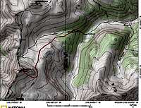 Treasure Creek Route
 Waterfall #5
 Decision Time
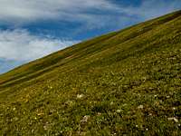 South Slope
Once you have a full view of the Summit Peak's steep, grassy, south-facing slopes, leave the trail and head for the summit. Aim for a notch near the summit. In good weather and in summertime, this is a delightful tundra climb surrounded by acres and acres of wildflowers.