Foreword
![Stymied!!]() 30 Metres of frustration 30 Metres of frustration |
I’m well aware that the very title of this TR is going to put people off reading it. That would be a pity in that we can learn as much, if not more, from our failures in the mountains as we can from our successes. And, no matter what the outcome, how could any perfect weather trip to a remote and seldom-visited mountain ever truly be considered “a failure”? Perhaps when I tell you that failure was a question of a mere 30 metres it might pique a little interest. No? What was that? You’ll read it if I include lots of nice pictures. Right - you've got a deal.
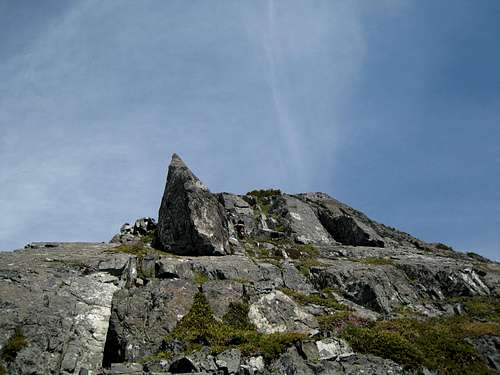
![Conuma Peak from Victoria Peak]() Conuma from Victoria Peak
Conuma from Victoria Peak
The first time I became aware of Conuma Peak was whilst climbing
Victoria Peak in August 2004. From the summit the views of the snow capped mountains of Strathcona Park and the north Island were as breathtaking as ever but what really intrigued me was a distinctive, sharp little needle well over to the west, almost as far west as the ocean in fact. My climbing partner was as mystified as I was, so bearings and photos were taken, notes made and we headed down and back to civilization. Until we got too low, our mystery peak was in view all the way down the south face of Victoria.
A few days later and after a bit of research and a few phone calls, I’d identified the mountain as both a historically important navigation aid for ancient and modern mariners alike and as a cultural icon of the Mowachaht First Nations. They called it “Konoomah”. Nowadays we know it as “Conuma Peak”. Its distinctive shape from some aspects and its proximity to the Sound of the same name, led some, apparently, to give it the local nickname “The Nootka Matterhorn”. With a CV as distinguished as that, it went down instantly on my tick-list.
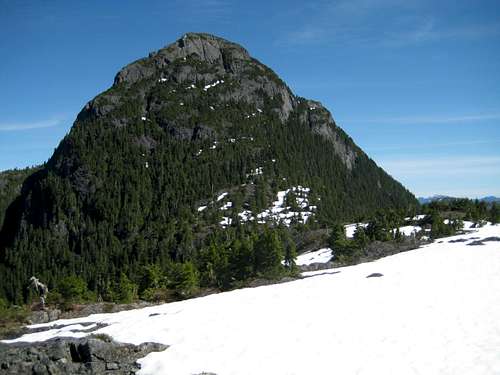
![Conuma Peak]() Conuma Peak
Conuma PeakFirst Try. September 15, 2007.
Fast forward to September 2007. After
a successful day on Pinder Peak, Tony and I headed over to the west coast in beautiful weather for a shot at Conuma.
![Park/Camp]() Park & camp here.
Park & camp here.![Approach Road]() East side approach road to the lower S ridge
East side approach road to the lower S ridge![The Real H-60]() The "real" approach road
The "real" approach road![H60D Blocked]() H-60D decommissioned
H-60D decommissioned![Not This Way!]() Not this way!
Not this way!
In the intervening 3 years I’d read all there was to read about the mountain.
Its history, the tales of the natural arch on the west face and, in particular, all the approach and climbing beta. There’s not a lot since the mountain receives few visits. On average, probably one ascent every 3 years or so. However, what information there was seemed straightforward enough. Locate logging spur H-60 off Head Bay Road, drive up it on the east flanks of the mountain until it hits a patch of old growth, climb up through the forest to the north end of the south ridge and then just a hop, skip and jump up the south face to the top. Piece of cake.
We found H-60 with no problem, slipped the truck into 4WD and bounced happily up the spur in search of a spot to camp. After a kilometre or so, “H-60D” branched off to the right. The main line, however, kept straight on. Up we went, grinding the bumpers on the ditches and bashing down young alders by the dozen before finally finding a nice flat spot right where the mature forest came down to the road as described. Perfect!
The next morning we got up to clouds, rain and low visibility. That fickle bird “motivation” was not long flying the coop. Before it did, however, we had plenty of time to recognize that something wasn’t right. Tony’s GPS had us over 3 km from the summit, not about 1 km as we had expected. Exploratory forays up logging slash as well as old forest led to impassable bluffs. Walking up the rest of the road took us further away from, not towards our objective. Mystifying stuff until we finally got it into our thick skulls that we were not, in fact, on H-60. There it was below us snaking up the valley to our east and towards Conuma. Yes, you guessed it, “H-60
D” was the spur we wanted.
By the time we’d got our feeble minds around this fact it was too late to do anything anyway but at least we’d go and have a look at the right approach for next time. That didn’t help either. Just 100 metres down H-60D and the road had been deliberately de-commissioned by removing a bridge. So that looked like that for Conuma. We invested a few expletives on the logging company’s selfish and antisocial practices (forgetting for the moment that they hadn’t actually built the road for the convenience of the handful of folk on the planet who one day might want to climb Conuma) and retreated in disorder.
A couple of weeks later a friend climbed an unnamed peak to the east and presented us with a nice photo of Conuma’s eastern aspect. From this we could see where we were, where H-60D (no longer) would have taken us and revealed the simple fact that climbing the slash at the end of our approach would have led to the south end of the south ridge from which it should be possible to approach the summit block. A route essentially parallel to and above the no-longer-viable H-60D. Given the road closure, approaching Conuma was going to be a lengthier proposition than previously but since I’d rather walk a ridge than a logging road, this looked like a perfectly acceptable alternate way to get at the mountain. The same friend also supplied photos taken from the summit of Conuma which showed the south ridge approach, as well a road “C15” that went high on the west side from the Conuma River valley. Almost as high, in fact, as the crest of the south ridge at its south end.
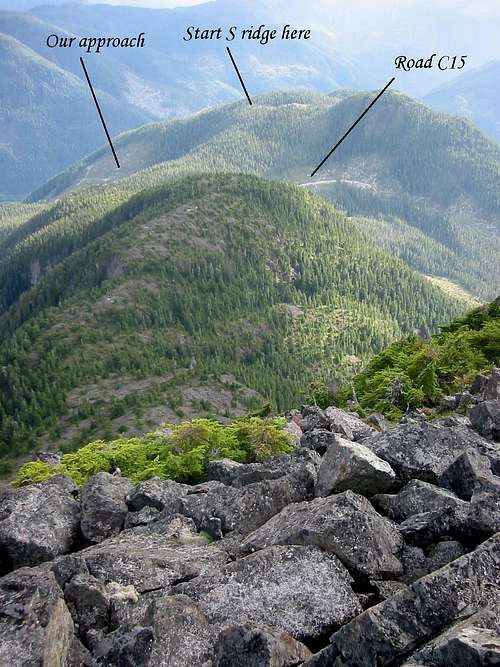
![Conuma Peak South Ridge]() The south ridge and east and west side approach roads from the summit of Conuma
The south ridge and east and west side approach roads from the summit of Conuma
We duly made plans for the following season.
Second Try. July 10/11, 2008
Fast-forward once again to July 2008. This time, we drove up in plenty of time to explore both avenues of approach.
The west side approach was uppermost in our minds. Spur C15 off Conuma Main was easy to find and in great shape. The problem was that its excellent condition was due to the fact that it was being actively logged. New roads were also in the process of being built all up the valley. A rope barrier across the road after a kilometre or so forbade progress, even for company personnel. However, it was after-hours and no-one was around, so we ducked the rope and drove on. After another kilometre the road deteriorated and then became impassable at another removed bridge.
By this time we were obviously above the active logging so we discussed whether we might camp in a secluded spot and walk up the rest of the road to where we could access the south ridge the next day. However, the legal – not to mention safety – aspects of this concerned us and so we drove down, round to the east side of Conuma, up our old friend H-60 (past H-60D of course) and back to our camp site of the previous year. Nothing had been disturbed. There were no tyre-tracks. We were obviously the only human visitors to have come this way in the intervening period.
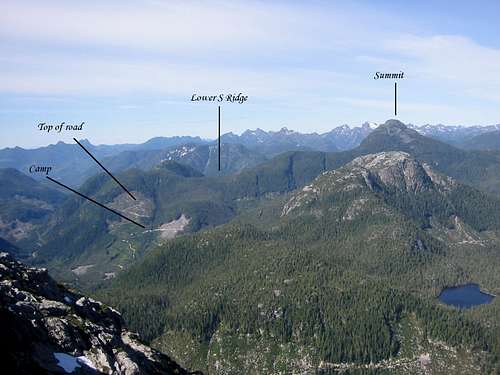
![Conuma Peak East Aspect]() Our final choice to approach and climb Conuma from the east side
Our final choice to approach and climb Conuma from the east side
The next morning we were up before 5 and off just after 6.15 am in peerless weather, confident of lunch on a sunny summit.
![Logging Slash Start.]() Logging slash
Logging slash![South Ridge Bush]() Thick bush
Thick bush![The South Ridge]() The south ridge
The south ridge![Summit Block]() Summit block from upper S ridge
Summit block from upper S ridge![Traversing the South Face]() Traversing the south face
Traversing the south face![West Face Gully]() West face gully
West face gully![Tahsis Inlet]() Tahsis Inlet - to the west
Tahsis Inlet - to the west![Strathcona Park Mountains]() Strathcona Park - to the SE
Strathcona Park - to the SE![Looking Down the South Face]() Looking down the south face
Looking down the south face![Preparing to Rapp]() Preparing to rapp
Preparing to rapp![Conuma Peak: Waterfall Pitch]() Rapping the waterfall
Rapping the waterfall![Upper South Ridge]() Returning along the upper S ridge
Returning along the upper S ridgeWell before 8 we’d walked to the end of the road that approached closest to the south ridge on this side of Conuma, climbed very reasonable logging slash and thought we were looking at nice friendly old growth forest. Our initial course took us almost due west up to the top of the slash, the aim being to do an end-run around the top of a deep undergrowth-choked gully that split the east side of the ridge at this point. Once in the old growth, we turned northwest around the top of the gully. Well that was the theory and what the GPS told us we did.
The reality was rather different. This is south facing terrain, so dense huckleberry bush greeted us almost as soon as we were above the slash and clasped us warmly and permanently in its loving embrace. The big gully could have been 5 metres away and we wouldn’t have seen it! This wasn’t intermittent bush. There were no more than a couple of all-to-brief isolated clear spots – from which we could glimpse C15 below to the west - as, for the next 3 hours or more we battled our way north along the ridge, up and down over several high points, before finally emerging, battered and scratched, onto a flat section of the ridge and easy going on snow. The steep summit tower was just a few minutes away and looked quite intimidating.
Conference time. The bush along the ridge had sapped energy and time. Almost every step of forward progress had been a fight with the thick undergrowth. With an eye on the need to reverse all this we had been navigating carefully and this had also used up the hours. Quite obviously, the time needed to descend would be no less than that needed to climb the mountain. With almost 5 hours required to reach this point, we set 1 pm as a turn round time, prepared to endure a 14 hour day and scarfed down an early lunch.
The route onto the summit block took us north via a brief descent and around the top of the last gully that comes up the east face. This is the approximate point where the route up from H-60D strikes the south ridge – or so I’m told.
Once onto the south face proper, we were able to climb the first 50 or so vertical metres on snow fields interspaced with more huckleberry. Thereafter, we swapped the huckleberry for krumholtz and made progress by hauling ourselves up rock difficulties with the undergrowth. It was apparent that we were never going to escape from bush in some form or other today! Twice we were forced into long traverses to the left (west) in order to find weaknesses through or a way around the big bluffs above us. Finally and almost at the west edge of the face, we found a long ramp that finally took us out of the vegetation, back to the right and deposited us at the top of an almost vertical gully coming up the west face. All this took time, however, and, at this point, we were already 15 minutes past our turn-round time.
Above us was a striking shark-fin shaped pinnacle right on the ridge edge with a series of steep slabs to its east. Above the slabs and to the right was the summit. My altimeter put us 60 vertical metres shy of the summit and that looked about right.
I thought I could see a line through the slabs with an exit up a flower filled groove, so up I went. If we were to maintain even a semblance of the self-discipline implicit in setting a turn-round time, there was minimal time available for discussion, to pick an alternate line or to gear up.
The climbing was 4th Class, steep and exposed and I immediately wished I’d roped up. After some dicey moves I finally hit the wall – actually and metaphorically - at the bottom of the flower filled groove. It was almost vertical with no obvious purchase for hands and feet. A crack to its left offered plenty of potential for pro – but I’d chosen to do this solo. I needed to make two moves to get above the difficulties, whereafter the summit, now only 30 vertical metres above, was ours, just a short walk away. It may as well have been 300 or 3000. Un-roped, this line was beyond my level of courage and I knew it. A very nervous down-climb back to Tony, all the while trying to ignore the exposure, soon confirmed the wisdom of my decision.
By now, we were 45 minutes past our turn-round. Yes, I could see another possible line and yes, I knew my original line would go with the comfort of the rope but this was all academic. Tony had gracefully indulged me this far. To ask for more was beyond unreasonable. So we took all the usual photos, I took one last look at the summit and we turned for home.
With the benefit of the GPS up-track we were able to reverse the summit block tidily enough. A minor hitch developed when we didn’t fancy reversing one of the bush-filled grooves we’d climbed up and which didn’t offer anything obvious to rappel off. However, a waterfall-like feature just to its west had a handy tree at the top, so out came the rope and down we went.
Apart from the brief open interlude on snow at the top end of the south ridge, we were soon enveloped once more in the bush and slavishly following the GPS track for hour after hour down the ridge with nothing to see but foliage a few inches from your face and, frequently enough, not even your partner.
Finally at 7 pm we reached open terrain at the top of the slash and the car just before 8 for a long, long 14-hour day. My GPS showed an accumulated distance of 13.1 km and accumulated relief of 1,830 metres, the majority of it over difficult, bush-choked terrain. No wonder it took so long!
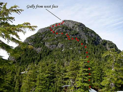
![Conuma Peak Route]() Our approximate route up the south face of Conuma Peak
Our approximate route up the south face of Conuma PeakEpilogue
For those who aspire to climb Conuma Peak, and unless they relish the prospect of what I would estimate as 7-8 km of thick bush on the ridge and another 2 on the summit block, I wouldn’t recommend our route. Instead, I would advocate walking H-60D and following the original route that ascends to the ridge just south of the summit tower.
On frequent occasions during the day, we both wondered whether we were on route or not. We saw not a single trace of anyone having been this way before; not one piece of flagging nor cairn anywhere on the mountain. Ascents of Conuma are infrequent at best. However, several accounts mention having to rappel or rope up for a pitch here and there. We saw no rap slings. Certainly no-one mentions a technical pitch right below the summit nor the characteristic shark-fin pinnacle. So, if anyone recognizes anything from my photos, especially those from the summit block, give me a shout. The best I can say about our chosen course is that it was
a route but perhaps not
the route.
The west side approach via spur C15 may one day be open to the public and remains an option. However, although it looked like a short, easy climb up to the ridge crest from that side, looks can be deceiving and, even then, it only saves the climber the time up to the crest above the big gully – perhaps an hour. The whole of the lower south ridge and all that bush still lies in store. Also worth mentioning in this paragraph is that, during the course of the day, we were shaken by two huge explosions from below us on the west side. Ample justification for our decision not to risk the wrath (or worse) of the crews down there during working hours and, perhaps, an indication regarding future difficulty of access from the west
It was a hard thing to do to turn around with success so close to hand. Some may offer solace along the lines of “what’s 30 metres” or “how different would the views have been from the top”. But as we all know, that that’s not how our game is played.
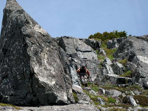
![High Point]() Close up of our high point
Close up of our high pointPage Visitors


Comments
Post a Comment