Trip Stats
Members: Gimpilator, EastKing, FTZE, Josh, Gabe
Equipment Used: Ice Axe, Snowshoes, Common Sense
Equipment Nearly Used: Avalanche Beacon, Shovel, Sattelite Radio, New Pair of Clothes Not the Wright Mountain: An Avalanche Tale
Introduction
Rarely do I ever write about trips where there wasn't a successful summit involved. However, this trip up Wright Mountain was an eye opener and well worth writing about. Though the trip lasted maybe six hours, there was quite a strong potential for this trip to have ended much differently than it did. We all learned plenty of lessons on this trip and the trip made all of us stronger. The largest lesson from this trip report is to always be aware of everything around you, and don't always trust the avalanche forecast.
Winter always has its surprises and today was a classic example of an avalanche surprise. Avalanche conditions were supposed to be low today but that didn’t quite turn out to be the case with the mountain that we picked. Wright Mountain was not the right mountain and luckily we found that out before something serious happened. I think all us of feel very glad that the outcome was so positive.
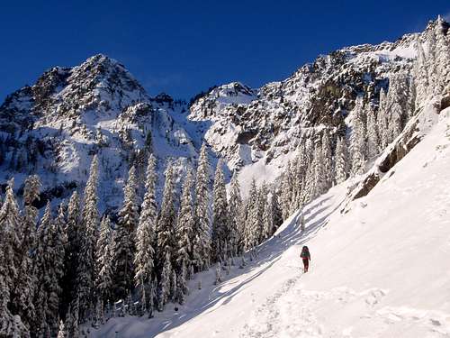
Gimpilator, Josh, Gabe, FZTE, and I decided to take a shot at Wright Mountain, which in summer is a fairly easy 12 mile 3000 foot elevation gain mountain right from the Alpental Ski Area. In summer, this mountain can be done in four to five hours. There is a great boot path that goes right around Snow Lake and heads right up to Gem Lake. From there, it is just a minor scramble to the summit of Wright Mountain. As you will see here Wright Mountain takes on a different character in winter.
The Beginning of the Trip
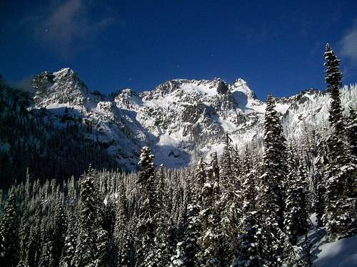
The weather today was cold and dry but visibility was perfectly clear. There was not a cloud in the sky throughout the beginning of the trip and it looked like all the forecasters that had called for little avalanche danger were going to be right. The only clue that there was going to be issues was the heavy wind. It was blowing snow off some of the higher peak and depositing it down below.
![View while heading up the Snow Lake trail.]()
We started off in the Alpental Ski Area and decided to head up the Snow Lake Trail. The Snow Lake Trail was very well used and there was a clear path from the trailhead on the way up. The views from the trail were absolutely breathtaking and clearly some of my best photography was taken today. This first section was easygoing and most of our breaks were to take pictures of the mountains. The well-used path headed all the way to the view of Snow Lake. The beauty from this trail was unreal and the mountains were very pretty in their winter setting. On the way up there were not too many people on the trail.
The First Hint
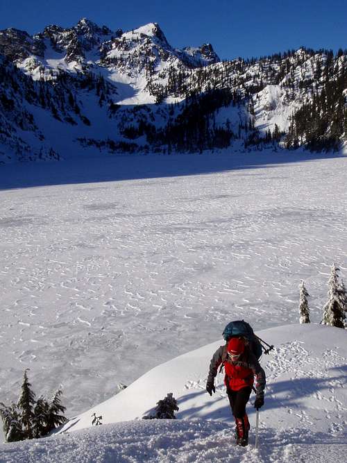
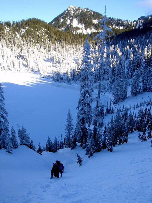
It was easy hiking to the viewpoint of Snow Lake. However, getting down to Snow Lake was a little more interesting. We decided to check a couple of slopes and glissaded down to the base of Snow Lake. Once at the base of Snow Lake we could see Wright Mountain. Josh took lead on the glissade and headed down the slope with Gabe heading right behind him. They set a good glissade path on the way down so the rest of us followed. I was the last one but I noticed on the way down I picking up a lot snow below my feet on a well-worn glissade path. Gimpilator and I tested the snow just to check the quality out. The snow was not compact at all, which gave us the first hint that the snow wasn't as stable as we were lead to believe. Luckily, we did not head too much more downhill and since we were at the base of Snow Lake, we were home free!! Or so we thought....
![Frozen Lake]()
It was tempting just to cross Snow Lake and get to Wright Mountain. But we didn’t trust that Snow Lake wasn't completely frozen over. Because of that judgment we decided to go around the lake on the east side to hit our vantage point. After the glissades there was at first a simple traverse along the side of the lake. This section eased our nerves and we were feeling confident again.
The Crux
Everything was going ok until we hit one tricky slope on our traverse. This 200 foot, 45-degree angle snow slope leads all the way to the frozen lake. What we didn't know was that this was one spot though where the snow must have blown off the lake and loaded this slope with snow. Gimpilator was looking at a traverse of a ridge when he noticed some cracks in the snow on the slope. He and Josh turned and headed down where me FZTE and Gabe were checking out the lower slopes.
Noting that we decided to head closer to the lake where we would stay low to cross the section. At one point a number of us stepped on the lake and quickly got reminded that the lake was not completely frozen. Seeing the bubbles rising to the surface woke Gabe up and we knew that we were not even going to be anywhere near that lake.
Figuring this was the crux we proceeded on and crossed the section on the safest section above the lake. Gimpilator took lead on this section and we all crossed the section one at a time. We stay about five to ten feet above the lake and kept our voices down through the section. It felt very scary walking between a frozen lake and a slope, which could possibly go at any time. However, we traversed through it and at this point we thought we were home free because all we had was a mile and a half left.
So after crossing this section we headed up a slope to what we thought was a ridge. After crossing that slope we didn't want to be anywhere near the slope of the lake again. We aimrf for the highpoint of a ridge where we could possibly traverse it all the way to Wright Mountain. Unfortunately, once we hit that ridge we realized that we were going have to go down and then head back up. So from here we decided to head down at the lowest angle of slope.
AVALANCHE!!! LET'S GET OUT OF HERE
By now we were checking for potential avalanche areas. Gimpilator and Josh were heading down the slope to check for cracks when Josh spotted a major crack in the snow right below his feet. Gimpilator spotted it early and cautioned us all of us. Josh took one kick at the snow and there went any plans, desire or thought of continuing this trip anymore.
At that very moment the snow raised and released a mini avalanche. The crack in the snow just rose up and then the entire slope just gave way. The section of the snow was 20 feet by 10 feet and to see it rise and then fall put fear into us. Luckily for all of us Josh was not taken from the avalanche and stayed above the falling snow. He was very fortunate to stay above the mini avalanche and though he was shaken, he was ok.
Without any hesitation we turned back. That was all the warning signs we needed. We were still 1.5 miles from the summit and there was no reason to go further. To be honest, even if we were 100 feet from the summit we probably would have turned back. We headed back to the top of the ridge took a small break and then headed on out of there. There we got something to eat and relaxed our nerves a little before starting our return voyage.
The Trip Back
We decided to head back the way we came because that area we knew best and we were too spooked to go up any new slopes. The crossing of that one slope was tricky but we did it the same way we did on our way up. We also stayed on the same trails that we established in order to not hit any undisturbed areas.
Heading up the glissade chutes we established was physically tough but it was much safer that attempting to climb a new undisturbed slope. This 50-degree slope was steep but it was disturbed and though the bottom was full of deep powder, the top of the slope was actually very stable for kick steps. All of us were slow on this section but we got through the section in good shape for the return trip back.
Once on the top of ridge with the view of Snow Lake we knew we were home free. On the ridge though head back to Alpental there was actually a well-used glissade path that went down to the Snow Lake Trail. This was a quick fun ride down to the path. Some of us glissaded all the way down the safe slope while others just glissaded to the trail.
On the way back down the Snow Lake trail was much more crowded. We all made a quick pace back to the car. Gabe likes to run down trails and this well used path was no exception. So he did his typical run down this slope while the rest of us did more of a fast paced walk. Soon we were back at the car where took a deep breath and a sigh of relief after witnessing that mini avalanche first hand.
Conclusion
Overall it was a good trip, but we were very fortunate with the outcome. It will go down on paper as an unsuccessful attempt on good weather. But this trip could have different. First, we will not ever trust the avalanche forecast ever again and err always on the side of caution. Second, I think we will stop on the first sign of poor conditions, not the second or third. That being said though it was a great trip and I hope we all combine again to do a ton of other mountains.


Comments
Post a Comment