
|
|
Route |
|---|---|
|
|
47.30953°N / 120.51418°W |
|
|
Hiking |
|
|
Spring, Winter |
|
|
Most of a day |
|
|
Overview
The western approach starting from Upper Tronsen Road is the recommended summit approach for snowy Winter/Spring ascents of both the north and south peaks of Mount Lillian, when the surrounding roads are all covered by snow. The south peak is more commonly climbed, largely because it is the higher point of the two Mount Lillian summit hills. Due to limited prominence of the north peak, it is actually just a sub-summit rather than a true mountain.Although the most of the peak can be driven during Summer & Autumn seasons, the snowy Winter/Spring route has its advantages. In example, the route basically has no avalanche danger due to mostly low-angle terrain and thick evergreen forests. It is a fairly direct snowshoe route which, if on a good-weather day, could offer fantastic views of the surrounding regions. This helps make the route a good choice for novice snowshoers, too.
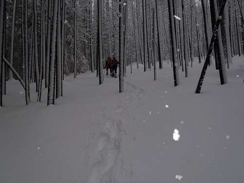 Heading through low-angle forested terrain...
The main points of caution are potential tree-wells covered by snow and the possibility of getting lost along the way. Although the route is fairly direct, much of the terrain, hills, and forests resemble each other, so a GPS device is highly recommended.
Getting There
This route originates only one mile north of Blewett Pass (Highway 97).DRIVING DIRECTIONS FROM CLE ELUM:
1) Starting at Interstate 90, take Exit 85 (for WA-970). Head north from I-90.
2) After 0.5 miles, reach a "T" intersection. Turn right (east) onto WA-970.
3) After 9.8 miles, continue straight (northbound) onto Highway 97.
4) After 15.0 miles further, only 1.0 miles north of Blewett Pass, pull off the highway near the entrance to Upper Tronsen Road (on right side of highway).
NOTE: This road is also known as Road 7240, which is used as the main access road for Tronsen Meadow and Tronsen Creek.
------
DRIVING DIRECTIONS FROM LEAVENWORTH:
1) Starting at Highway 2, head east from Leavenworth for approximately 4.0 miles, until reaching the road junction with Highway 97.
2) Take the rightside ramp for southbound Highway 97.
3) Drive Highway 97 for approximately 20.2 miles, until reaching Upper Tronsen Road (on left side of highway).
NOTE #1: This road is also known as Road 7240, which is used as the main access road for Tronsen Meadow and Tronsen Creek.
Route Description
 General Route Map
STARTING FROM INTERSECTION OF HIGHWAY 97 & UPPER TRONSEN ROAD:
1) Hike southeast along Upper Tronsen Road.
2) After approximately one mile, turn left at a road junction.
NOTE: As a reference point, continuing straight (Road 7240-411) would parallel a fenceline towards Tronsen Meadow.
3) After turning left, follow the road for approximately 0.5 miles further (until approximately 4230' elevation).
4) Before reaching Tronsen Creek, leave the road and begin heading off-road in a general southeast direction. Make certain to always remain south of Tronsen Creek, as the topographic contours are much wider and favorable on that side.
5) Between 5200'-5500' elevation, the terrain becomes steeper and the slopes "V" towards the saddle where Tronsen Creek originates.
6) After 5500' elevation, the terrain becomes more level and soon a road (Road 9712) is encountered. Cross the road and head east-southeast around the northside of Haney Meadow.
7) Continue generally eastbound and uphill. An upper section of Road 9712 will be encountered at nearly 5800' elevation.
8) There are two main options from this location. Either...
8a) Continue directly eastbound and uphill for the final 400' to the summit. Several closely-placed false summits will encountered prior to the true summit (south peak) of Mount Lillian.
or
8b) Follow Road 9712 south-southeast until Road 9712-626, then follow abandoned Road 9712-626 northbound until its end, and then continue off-road to the summit.
 At the summit...
------------
For the north peak of Mount Lillian, head due north from the south peak for approximately 0.75 miles. Then to return, head westbound and downhill to Road 9712 and follow it downhill until reaching the original route path.
------------
The snowshoeing distance for the south peak (only) is approximately 8.5-9.0 miles roundtrip, and for both peaks is approximately 9.5-10.0 miles roundtrip. Most snowshoers take 5-7 hours roundtrip, depending on snow conditions, weather, and fitness level.
Essential Gear
-> 10 Essentials-> GPS (!!!)
-> Trekking Poles
-> Snowshoes