PART I: Making A Leap Towards A Plan
I had been wanting to summit Frog Mountain since last summer, when I first really started to realize the gorgeous landscape of the peak. However, Frog Mountain was covered with thick underbrush, especially salal, which would have made any such attempt a true bushwhacking adventure. After talking with a couple of hikers who had already summited Frog Mountain, I was told that late Winter/early Spring might be the best time to enjoy the summit climb. During that time of year, the mountain tends to have a lot of consolidated snow (nicknamed "Cascade Concrete" by some locals), meaning traditionally less avalanche danger, but the underbrush has not grown wildly yet. I kept hoping to climb the peak in late April, but I found I either had prior commitments or there was considerable avalanche danger when I did not have commitments. My plan was put on hold.
Then, on May 2, I hiked to
Dirtybox Peak. By the time the hike ended, the heavy weight of my pack and the steep ruggedness of the route took its toll on my legs. I had been anticipating doing a hike with another SPer the following day, but, although I still had a lot of energy, I was concerned my legs might be too tired to do another rugged mountain hike in such a short time. As the day progressed, I rested as my legs recovered.
The next day, May 3, I visited with some family members for the first part of the day. My legs still hurt, early on, but seemed to feel better as time progressed... the slight pain was nearly non-existent by noon. Already in Gold Bar, Washington, and still having my backpack and supplies in my car from the prior day's trek, I saw good weather above and began craving a mountain climb. Looking at the time, it was already too late to notify the SPer whom I was originally going to hike with that day. Remembering my earlier research for Frog Mountain, and having heard it was fairly non-technical to climb, I figured it would provide a good, relatively easy backcountry hike that would not bring too much stress to my already-sensitive legs. Considering I had a map and supplies in my car, I was already prepared.
PART II: Jumping Into Action
![Forest Road Block]() Beginning To Clear Tree From Road...
Beginning To Clear Tree From Road...
By 12:40 PM, I was heading north along Forest Road 6500. However, about six miles in from Highway 2, I came across a tree lying across the raod from a streambed that triggered slope erosion on the west side of the road. A truck containing several men had arrived shortly before me, and another truck arrived shortly after me. We were not certain how long the tree had been down, but we knew it must have been a recent occurrence as a few of us had heard about people driving up and down Forest Road 6500 during the previous few days. We all worked together to cut down branches and tie rope around the downed tree. The first truck tied the other end of the rope to the truck tow-hitch, and was able to pull the tree out of the way... snapping off the top of the downed tree against a standing tree during the moving process. Each of our vehicles were then able to continue north along the road.
When I reached Jack Pass (2580' elevation), I parked my car while the two trucks continued. I was shocked to discover another car recently parked at Jack Pass, indicating that the downed tree south along the road had probably fallen earlier that day. By 1:00 PM, I was putting on my Microspikes and beginning my snowbound hike. Initially I began walking due east through the lowland forest, directly toward Frog Mountain, but decided to change my route once I began heading downhill. My goal was to eventually travel atop the rocky ridgeline north of my location, and although I could have bypassed much of that ridgeline by continuing due east I was concerned that initial route might ultimately become steeper than I preferred to travel. Instead, I opted to head due north to the western base of the rocky ridgeline and then head east along the ridge itself.
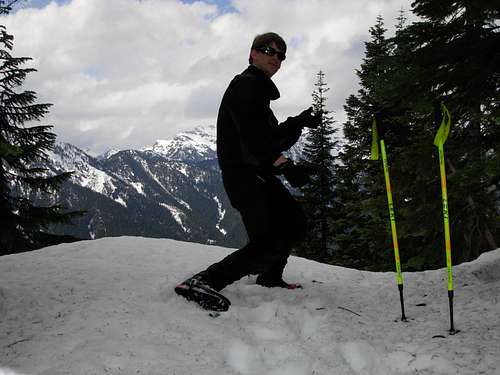
![Me, On Frog Mountain]() Standing On Western Slope...
Standing On Western Slope...
During the traverse along the top of the ridgeline, I encountered some areas where postholing in the snow occurred and other areas where I had to scramble up minor rocky sections. The ridgeline was fairly straight-forward, with the general direction heading east. I kept monitoring my progress with my GPS, but the intended summit route was easy to maintain. Walking through a snow-covered forest was fun and peaceful. Grouse could be heard calling throughout the forest. When I reached approximately 3800' elevation, I noticed the treecover thinning out considerably as the western slope of Frog Mountain steepened. The first stage of the climb was ending, but another stage was about to begin...
PART III: Trying Not To Croak...
As I began climbing up the steep snowy slopes above 3800' elevation, I grew immediately concerned about avalanche dangers. Although avalanche dangers were low that day and much ofthe snowcover was consolidated, the upper western slope of Frog Mountain was so steep that I took extra caution with my steps. As I ascended the slope, I tried maintaining a path towards the next stray tree... for protection, just in case of an unexpected avalanche. The views from this slope were outstanding. Fortunately, I was able to reach the false summit (4600' elevation) and the western summit ridge without complications.
When I reached the ridgeline, I immediately noticed a single set of animal tracks in the snow and leading towards the summit. Upon closer examination, I realized the tracks had been very recently made by a mountain goat. I followed the tracks along the ridgetop, then up the final 200' elevation to the true summit (4872' elevation) of Frog Mountain. It only took nearly 3h00m to reach the summit, which I was very satisfied with considering I had no path to follow and took my time during the ascent. The mountain goat tracks continued east. I was shocked to have cellular phone service at the summit, so I called my wife and told her that I made it to the summit and was about to begin my descent.
![Frog Mountain Summit Ridge]() Failed Attempt At "Thumbs Up" Pose
Failed Attempt At "Thumbs Up" Pose
During my descent of the steep western slopes of the mountain, I began to occasionally notice tiny slabs of the snowy top layer break off and slide down with some of my steps. The sun was shining bright on the slope. I slowed down my descent, considerably, and used extra caution not to trigger any avalanches. Once I reached the thick forested region below 3800' elevation, I felt much safer and quickened my pace again. When I reached approximately 3100' elevation, I reviewed my map and GPS, and determined to try heading due south rather than follow the lower ridgeline I used for my ascent. I did not want to climb down some of the ridgeline scrambles. Instead, I headed down steep forested slopes to a streambed at the bottom, then up a hill for a short time, and then downhill to Jack Pass. When I reached my car, I noticed my descent time had only been 1h30m (half my ascent time). I was very happy with my time, and being able to successfully climb Frog Mountain safely and without added pains. I will definitely recommend this mountain as a late Winter/ early Spring climb to other people, and I know I will eventually return as well.
Comments
No comments posted yet.