
-
 8540 Hits
-
 90.13% Score
-
 31 Votes
|
|
Route |
|---|---|
|
|
Hiking |
|
|
Spring, Summer, Fall, Winter |
|
|
Half a day |
|
|
Hike, Ladders |
|
|
Overview
 Tsankawi scenery
The National Park Service administers this site as part of the Bandelier National Monument (the actual Bandelier is about 10 km west). Tsankawi Ruin trail is an excellent introduction to the ancient people who once inhabited the Pajarito Plateau and whose descendants now live in the pueblos along the Rio Grande.
Just why they chose this site is a mystery. Certainly the Indians would have enjoyed spectacular scenery. To the east, across the Rio Grande Valley, are the high peaks of the Sangre de Cristo Mountains. To the west and north are the Jemez Mountains, and to the South are the serrated Sandia Mountains.
But scenery is a poor substitute for water, which is lacking on the mesa (be sure to take some). Though mesa top reservoirs would have held occasional rainwater, these would have been inadequate during dry seasons, and the nearest reliable water sources are far away. And while the cliffs ringing the mesa are excellent defensively, archeologist say they've found no evidence of warfare.
The name Tsankawi comes from Tewa words meaning "village between two canyons".
Type: day hike, can be easily done in a couple of hours, but most people spend time exploring the caves, searching for petroglyphs etc.
Children friendly. Dogs not allowed since it is a part of the National Park system.
Starting elevation: 6,500 feet. High Point: 6,680 feet
History
 Anasazi dwellings
 Rock art on the cliffs
In the 1100s, Tsankawi was home to the Ancestral Tewa Pueblo people. Today their descendants live in nearby San Ildefonso Pueblo. The Ancestral Pueblo people build homes of volcanic rock and adobe (mud), cultivating fields in the open canyons below. Although the present day Pueblo people do not occupy Tsankawi, the site serves as an important role in their spiritual lives and provides both connections with traditions passed through generations.
The mesa was inhabited for about 400 years. In the late 1500s, after the Spaniard's had arrived, the pueblo was inexplicably abandoned, as were many villages of the Pajarito Plateau.
Location
 Sangre de Cristo Range
 Evening sun on the mesas
Tsankawi is located on the Pajarito Plateau, a place of canyons and mesas. The area receives minimal precipitation (about 15 inches per year) mostly in the from of snowfall and late-summer thunderstorms.
To reach this place drive west from Santa Fe, capital of New Mexico towards Los Alamos. Take US 84-285 north 10 miles to Pojoaque, then drive west towards Los Alamas on NM 502 for 10 miles to the junction with NM 4 (direction for White Rock). Drive southwest on NM 4 for about 1 mile; Tsankawi Ruins parking area is on the left side of the road and is marked. The parking area is pretty small (right at the traffic lights where the road spits for Los Alamos and White Rock). It is about 30 min drive from Santa Fe. The parking is free, but you have to pay a fee for using the trail - self pay station as you enter through the gate.
Restrooms are behind the gate as well as some information area.
Route Description
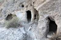
The trail, which is a loop, is mostly level, but some sections involve climbing pole ladders and ascending narrow crevices - just as the ancient Indians did. Children will love these features. The trail takes you first onto the mesa's top. Here are ruins of a small village, now mostly mounds of rubble but with some remains of walls still visible. The views are spectacular.From the mesa top you descend via a ladder to the shelf surrounding most of the mesa. In the soft stone - compressed volcanic ash - are grottoes and caves. Some of these were enlarged and shaped by ancient residents into rooms for dwellings and storage. Children love to crawl in and out of these (me too:). The smoke-blackened ceilings show that people once spent cold winter nights here.
The trail is easy follow and it has several numbered stations with explanatory readings from the guide you can pick up at the start of the trailhead. Enjoy...
 Narrow trail Narrow trail |  Inside the dwelling Inside the dwelling |  Down on the ladder Down on the ladder |  Anasazi steps Anasazi steps |  Little exposure on the way back Little exposure on the way back |
External links
National Park InfoWikipedia info
Info from science reviews
Southwest archeology