Finding Our Way
I had been thinking about going to North Gardner Mountain and Gardner Mountain for at least 1-1/2 years, but kept waiting for the best conditions for ascents. This past weekend (June 25-27, 2010), I think that goal may have been accomplished, although not as I had originally planned.
I asked Gimpilator to accompany me on this trek. My main objective for the trip was North Gardner Mountain, the Okanogan CoHP, and Gardner Mountain due to its close proximity. We also considered attempting Abernathy Peak and Wolf Head (Lamont Mountain), but we ultimately would end up deciding against attempting either of those choices.
We each had a half-day at work on Friday and drove that afternoon to Winthrop. Our goal was to get to the Wolf Creek Trailhead by 5:00 PM, and we were on schedule to be earlier than that time. That's when something unexpected happened. I have several books and several online printouts specifying the driving directions to the Wolf Creek Trailhead. ALL of them, some from very reputable sources, were incorrect. It was so bad that even the access directions on the USFS website were even outdated.
Whether it be road names, road distances, and/or key turnoffs, each of the directions had flaws. This caused some confusion and we found ourselves on a couple of incorrect roads. Frustrated, I was able to use my GPS to match up its shown contours to my map, and trace the correct route to the trailhead... eventually finding trail signs along a road closer to the trail. We think somebody tore down the trail sign(s) closest to town.
Side-Note: Thanks to Bob Bolton for immediately correcting his "Getting There" instructions for the North Gardner Mountain page on SummitPost, as soon as I notified him of the updated driving directions.The Journey To Camp
We arrived at the Wolf Creek Trailhead after 5:00 PM, and were hiking by 5:30 PM. I brought several pieces of gear, such as my bivy sack, which Gimpilator thought was overkill but I thought might be needed in case of an emergency. With ~10.2-10.5 miles to Gardner Meadows, we were not certain if we would make it all the way with daylight but we were ready to use headlamps if needed. The biggest thing in our favor was that we were within a few days of Summer Solstice, so daylight would potentially be later than normal.
Within the first mile, we encountered two female rangers hiking back towards the trailhead. They told us we were the only guys out there, and that there was one group of three women (and a dog) from Everett and a group of two women from Winthrop further on the trail. They also gave us a tip for where to cross the major creek crossing at 2.3 miles in... several large branches had been placed across that creek, forming a rugged "bridge" of sorts. It worked, although that creek crossing definitely needs to be addressed in a more long-term manner than a few branches.
![Creek Crossing Along Wolf Creek Trail]() Gimpilator Crosses Creek Along Wolf Creek Trail...
Gimpilator Crosses Creek Along Wolf Creek Trail...
We made good time, reaching Gardner Meadows (~5700' elevation) by 10:00 PM, only 4h30m after we left the car. We crossed the stream that flows south through the meadow area and found a tiny grove of evergreen trees on the left (south) side of the Wolf Creek Trail. One of the trees, upon closer inspection, was a live old-growth tree. Within the tiny grove was an open area wide enough to setup a good-sized campsite. After gathering and filtering some water, we ate some freeze-dried meals and soon got ready to rest. Shortly before arriving at our campsite, Gimpilator realized that he had forgotten, of all things, his sleeping bag. Neither of us planned to sleep in one sleeping bag, so he borrowed my bivy sack and wore extra layers. I offered my heavy winter gloves and balaclava in case he got too cold, but those items were not necessary.
Two Tall Peaks, One Long Day
We woke up at 4:40 AM the next morning. As we readied our gear for the day's goals (North Gardner, Gardner) and ate breakfast, a mule deer entered our campsite looking for salt. The deer was not completely spooked my our movement, but was always certain to be at least 15' away from either of us. Looking up on the hillside to the north, the meadowy slopes were full of grazing deer. Fortunately, we had already taken precautions against such visitors by storing/hanging our food at a location away from our campsite.
![Campsite At Gardner Meadows]() Campsite At Gardner Meadows
Campsite At Gardner Meadows![Deer At Gardner Meadows]() Mule Deer That Visited Our Campsite
Mule Deer That Visited Our Campsite
We began hiking at 5:45 AM. We first hiked uphill north, then northwest, reaching a meadow basin at ~6200' elevation. We were approaching a small south-trending ridgeline coming from Gardner Mountain, but we could not quite yet see our first objective... Point 8487 and the gully/bowl below its southeast side. Once we crossed WNW over the ridgeline and continued that direction, those locations soon came into view. The entire bowl southeast of Point 8487 was still filled with snow. Late Spring avalanche dangers had already passed, with the last avalanches probably occurring within 1-2 weeks of our arrival, and the snow conditions were perfect for walking on. We each needed to use an ice axe and crampons for the ascent of the icy snow-bowl before direct sunshine hit the area, but then after that occurred (by the time we were only ~500' elevation below Point 8487) the crampons were no longer needed.
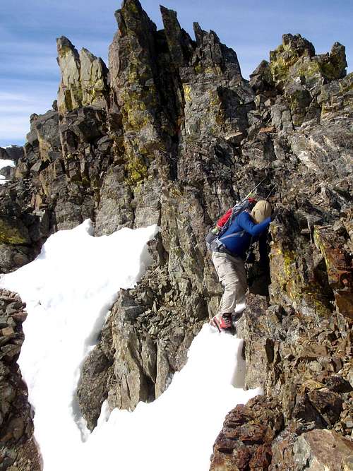
The loose scree slope near the Point 8487 ridgetop was annoying to ascend, but the ridgetop itself was quite easy to traverse. We took some moments to look at North Gardner, Gardner, Wolf Head, and Abernathy. We could see the two women from Winthrop ascending the snow-bowl, and they were quickly catching up to us. Soon we were heading north along the ridgeline towards North Gardner Mountain. Approximately halfway along the ridgeline, the two women passed us. It was not just a matter of us carrying much more weight than them; they were FAST mountaineers. There was one crux pinnacle to maneuver around and use extra caution, near the beginning of the ridgeline between Point 8487 and the North Gardner summit, but for the most part the traverse was straightforward. The mixture of snow and scree on the ridgetop was not too bad, and we reached the summit shortly after the women did, at 10:15 AM. North Gardner Mountain was my 21st Washington CoHP, and fifth this year.
![Two Climbers on the South Ridge]() Ascending South Ridge Of North Gardner...
Ascending South Ridge Of North Gardner...![The Crux]() The Crux Of The North Gardner Ascent...
The Crux Of The North Gardner Ascent...![At North Gardner Summit]() At The Summit Of North Gardner Mountain
At The Summit Of North Gardner Mountain
We spent 30 minutes at the summit, reading the summit register, snacking, and enjoying the views. The two women left shortly before us, with the same second goal: Gardner Mountain. As I walked away from the summit, I found a couple of rock slabs in the middle of a snowbank that were full of ladybugs. I thought it was fairly interesting, and wondered if they just wait there for the snow to completely melt or if they start flying away before that occurs.
![Hero Shot]() Thinking About The Next Goal...
Thinking About The Next Goal...
When Gimpilator and I returned back to Point 8487, we noticed the two women descending the snow-bowl. Figuring they were heading back to their camp rather than attempt Gardner Mountain, we briefly attempted to reach Gardner Mountain via the semi-popular Gardner Traverse. It would be the most direct approach from our current location, although we soon discovered that the mixture of loose scree and dirty snow in some inopportune sections of that ridge traverse. We decided to attempt Gardner Mountain by what had seemed the easiest approach: the south side of the mountain. Looking southwest down the slopes, we could see the two women suddenly side-traversing eastward... we figured they might have the same idea we did.
![Gardner Mountain]() Gardner Mountain
Gardner Mountain
We descended down steep scree to ~7400' elevation, and then side-traversed ESE around the Gardner Traverse cliff bands and south slopes until reaching a nice, wide, central snow gully heading up the middle of the south side of the mountain. It was a much longer route than we originally planned, but a much safer route as well. We soon located the tracks of the two women and decided to follow their route, as it was basically the same route as we planned to ascend and their tracks assisted our own ascent on the snowy sections.
![Ascending Gardner - South Slopes]() Gimpilator Ascends Central South Gully...
Gimpilator Ascends Central South Gully...![Ascending Gardner - South Slopes]() Gimpilator Ascends Upper Snowy Slope...
Gimpilator Ascends Upper Snowy Slope...![Gardner Mountain Summit]() Gimpilator Ascends To Gardner Summit...
Gimpilator Ascends To Gardner Summit...![At Gardner Summit]() Me, At Gardner Mountain Summit
Me, At Gardner Mountain Summit
The ascent was a combination of nice snow and loose scree. The snow only got bad during the last ~200' to the summit ridge, where the snow would be soft and deep in several places. We reached the summit at 3:10 PM, and Gimpilator soon demonstrated what over 8000' of total vertical gain in less than 24 hours can do to a person...
![Gimpilator Rests On Gardner]() What 8000'+ Gain In 24 Hours Can Do To A Person...
What 8000'+ Gain In 24 Hours Can Do To A Person...
After resting, snacking, and having a couple of telephone conversations on my cell phone, we began our descent by 4:00 PM. The two women left the summit about 10 minutes before we did, although they decided to attempt a different gully descent than the gully they had ascended. Having seen their gully choice from the meadow basin on the south side of the mountain, we believed the women might encounter some cliff bands that direction so we opted to basically descend the same route we ascended for the upper portions of the peak.
The loose scree was a lot of fun to descend. It was like a standing dirt/rock glissade in many places. The snowy sections helped our ascent, and the scree sections helped our descent. At approximately 7600' elevation, I found tracks crossing our previous ascent tracks in the snow. The tracks had not been there when we first traversed this particular slope, but I knew what the tracks were from... a large Bighorn Sheep. I wish we could have seen it, and this would mark the second trip that Gimpilator and I barely missed seeing a Bighorn Sheep on the east side of the Cascade Crest during the past year. From ~7500' elevation, we began descending due south down the mountain. Once we reached a top portion of the meadow basin at ~6500' elevation, we began angling ESE to our campsite.
![Descending To Gardner Meadows]() Looking Down At Gardner Meadows During Descent
Looking Down At Gardner Meadows During Descent
We arrived back at our campsite at 6:00 PM, only two hours after we left the Gardner Mountain summit. We made some freeze-dried meals and filtered some water. Shortly thereafter, our mule deer friend returned, hoping to find some salt. We had considered ascents of Wolf Head or Abernathy Peak for the following morning, but the approach conditions did not look good for either peak at that time. We left at 6:00 AM the following morning, arriving back at the car via the Wolf Creek Trail at 10:30 AM... still only 4h30m (just like our ascent had been). With some extra hiking included with the trip, by the time we reached the car we had done ~27-30 miles of hiking with over 9000' of total vertical gain in less than two days.


Comments
Post a Comment