
|
|
Mountain/Rock |
|---|---|
|
|
47.86415°N / 120.47146°W |
|
|
Chelan |
|
|
Hiking |
|
|
Spring, Summer, Fall, Winter |
|
|
6654 ft / 2028 m |
|
|
Overview
Tyee Mountain is a mid-elevation peak located along the Entiat River valley within Chelan County, Washington. Old roads and trails lead both to and near the peak, making this a popular destination for outdoor enthusiasts. However, the peak is most notable for the fire lookout atop its summit (6654' elevation). There are noteworthy views from the summit towards the lower valleys and nearby ridges, helping make this a worthy mountain destination. Western View From Summit
A L-4 cab fire lookout was constructed at the summit during 1931. That structure was replaced by another L-4 cab during the 1950s. During Summer of 1994, the fire lookout building nearly became a victim of the Tyee Creek Fire. On July 24 of that year, lightning storms started multiple forest fires near Tyee Creek along the south slopes of Tyee Mountain. The Tyee Creek Fire burned continuously for 33 days, consuming approximately 135,000 acres of mostly forested land and becoming one of the largest forest fires of the 1900s in the process of doing so. Thanks largely to the efforts of firefighting crews, and perhaps also with a lot of luck, the fire lookout at the top of Tyee Mountain survived the wildfire and is still standing. The Tyee Mountain Lookout Cabin is still service-ready, if needed, but is typically unmanned except during periods of potential high heat, fire, and/or lightning activity.
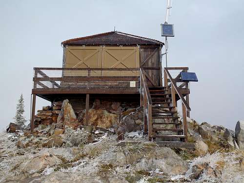
Tyee Mountain Lookout
In addition to the fire lookout building, some ridge markers as well as a small communications structure are also found nearby on the summit ridge.
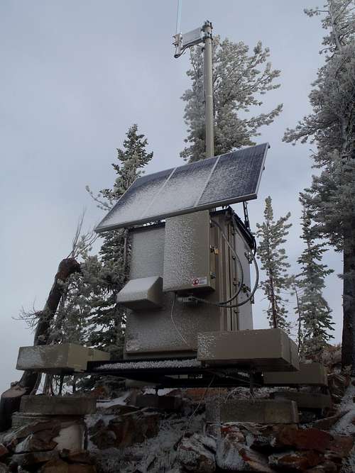
Small Communications Structure
A USGS Benchmark disk is found at the base of the cabin staircase.
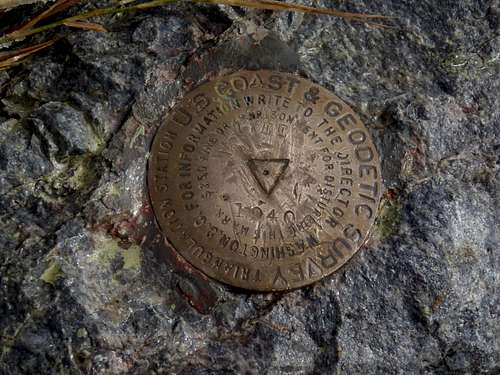
Tyee USGS Benchmark
Getting There
Most people who visit Tyee Mountain reach its summit via a driving approach. However, if wanting to drive to the summit, the vehicle should have high-clearance and 4WD capabilities for the final 4.2 miles leading to the summit. The roads prior to the summit road are each paved and in excellent condition, drivable by any street-legal vehicle.DRIVING DIRECTIONS (STARTING FROM THE TOWN OF ENTIAT):
1) Starting from Highway 97A, turn west onto on Entiat River Road (County Road 19) towards Glacier Peak Wilderness as well as the community of Ardenvoir.
2) After 9.8 miles, at the community of Ardenvoir, turn left onto Mad River Road (County Road 119A). This might be a good place to set your odometer.
3) After 2.1 miles, the road name changes to Forest Road 5700.
NOTE: This road name changes occurs where Forest Road 5800 (French Corral Road) intersect the main road from the south.
4) After 14.2 miles from Ardenvoir, turn right onto Forest Road 5713 (approximately 4400' elevation).
5) After 4.2 miles (18.4 miles from Ardenvoir), arrive at the summit of Tyee Mountain.
IMPORTANT:
-> Entiat River Road, Mad River Road, and Forest Road 5700 are all paved and drivable by any street-legal vehicle.
-> Forest Road 5700 is a single-lane road with multiple automobile pullouts and side-roads.
-> Forest Road 5713 is a very rough, rutted, rocky, steep road with very few automobile pullouts or vehicle turnaround opportunities. Those without a high-clearance 4WD vehicle can park alongside Forest Road 5700 and then road-hike 4.2 miles (one-way) to the summit, with over 2250' cumulative elevation gain. However, true hiking trails are also available (see next section on this page).
Hiking Options
Several official trails lead to and near the summit of Tyee Mountain.(NOTE: It is possible that some game trails and hunter trails might also be present on the mountain slopes, too.)
TRAIL OPTIONS:
1) Billy Ridge Trail #1413
The lower terminus and original trailhead for Billy Ridge Trail begins near the end of Forest Road 5715. However, few people hike the entire Billy Ridge Trail from its original trailhead anymore. Most hikers of this trail typically start at the Billy Ridge Spur Trail #1413.1, which eliminates 1.9 hiking miles each way from the full Billy Ridge Trail. The upper terminus of the trail ends near the final switchback of Forest Road 5713, requiring only another 0.5 miles and approximately 250'-300' of elevation gain of road-walking to the summit.
NOTE: The final switchback of Forest Road 5713 is the eastern trailhead/terminus for Tyee Ridge Trail #1415, which follows Tyee Ridge to/from Tyee Mountain and which is an intersecting trail for several of the approaches listed further on this page.
 Tyee Ridge, Near Tyee Mountain Summit
-> Starting at the original/lower Billy Ridge Trailhead (4400' elevation, 47.82560 -120.50491), the one-way hiking distance to the Tyee Mountain summit is 5.6 miles with over 2250' of cumulative elevation gain.
-> Starting at the Billy Ridge Spur Trailhead (4450' elevation, 47.83880 -120.50260), the one-way hiking distance to the Tyee Mountain summit is 3.7 miles with over 2200' of cumulative elevation gain. This is the recommended option for hikers of the Billy Ridge Trail going to the summit of Tyee Mountain.
------------
2) Billy Creek Trail #1416
Not to be confused with the Billy Ridge Trail, the Billy Creek Trail is located west of the forementioned trail and slightly longer from its middle trail junction. The lower terminus of the Billy Creek Trail originates at the Lower Mad River Trail #1409 at approximately 3400' elevation, but that trail junction is still 3.7 miles from the nearest road. Similar to the Billy Ridge Trail few people hiking to the summit of Tyee Mountain would start at the lower terminus. Instead, there is a trail junction where the Billy Creek Trail crosses Forest Road 5700, at approximately 5250' elevation. The upper terminus of the Billy Creek Trail is at its junction with Tyee Ridge Trail #1415, at approximately 6450' elevation. Starting from the middle trail junction, the Billy Creek Trail is only 0.5 miles longer than the Billy Ridge Trail but with approximately 600' less cumulative elevation gain.
-> Starting near the intersection of Forest Road 5200 and Forest Road 6101 at Maverick Saddle Campground (4200' elevation, 47.84251 -120.60156), hike eastbound along Lower Mad River Trail #1409 for approximately 3.7 miles to the trail junction with Billy Creek Trail #1416 (3400' elevation, 47.82791 -120.54195). "Cougar Creek Shelter" is a short walk beyond (east) the trail junction, for tired hikers seeking refuge. Starting at the western trailhead for Lower Mad River Trail #1409, the one-way hiking distance to the Tyee Mountain summit is 11.1 miles with over 4050' of cumulative elevation gain.
-> Starting at the middle trail junction (5300' elevation, 47.85850 -120.52560) with Forest Road 5700, the one-way hiking distance to the Tyee Mountain summit is 4.2 miles with over 1400' of cumulative elevation gain. This is the recommended option for hikers of the Billy Creek Trail going to the summit of Tyee Mountain.
------------
3) Mott Creek Trail #1422
Mott Creek Trail is significant because it was the major access trail for Tyee Mountain Fire Lookout and Tyee Ridge for many years, long before roads led to the summit and nearby slopes. Mott Creek Trail can still be hiked but is considered an abandoned trail, although hunters who visit the area tend to use and maintain at least the lower 1-2 miles of trail. Unlike the Billy Ridge and Billy Creek Trails, each of which traverse the west-southwest slopes of Tyee Mountain, the Mott Creek Trail traverses ridges north of Tyee Mountain. The Mott Creek Trailhead is located on the north side of the tiny community of Brief. The upper terminus of the Mott Creek Trail is at its junction with Tyee Ridge Trail #1415, at approximately 6400' elevation and approximately 5.5 miles from the trailhead.
-> Starting at the Mott Creek Trailhead (1700' elevation, 47.88343 -120.43522), the one-way hiking distance to the Tyee Mountain summit is 6.6 miles with over 5100' of cumulative elevation gain.
------------
IMPORTANT:
For more information regarding trail access and road access to Tyee Mountain and nearby areas, it is recommended to consult the following resources:
Green Trails Map #146 ("PLAIN"), Green Trails Map #147 ("BRIEF")
Entiat Ranger District
2108 Entiat Way, Entiat, WA 98822
Telephone: 509-784-7400
Red Tape
If wanting to drive to the summit, it is possible as long as the vehicle has high-clearance and 4WD capabilities for the final 4.2 miles leading to the summit.No parking permits or hiking permits are required to visit Tyee Mountain.
When to Climb
Technically, Tyee Mountain can be summited any season of the year. Most commonly, the summit is visited during Summer and Autumn months when snow is not present on the peak. However, snowshoeing, skiing, and snowmobiling opportunities are possible during Winter and Spring months, although with much more elevation gain and/or travel distance to consider.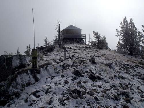
Summit Ridge With Some Early Season Snow...
Camping
Backcountry camping is allowed on Tyee Mountain and its surrounding terrain.However, no public overnight stay is allowed in the fire lookout cabin.