
-
 3332 Hits
-
 72.08% Score
-
 2 Votes
|
|
Route |
|---|---|
|
|
50.60000°N / 115.0306°W |
|
|
Mountaineering |
|
|
Summer |
|
|
Most of a day |
|
|
Moderate Scramble |
|
|
Approach
This is a 2500’+/- ascent day (accumulated elevation gain is considerably more due to loss and regained elevation). Mount Tyrwhitt itself is a short moderate scramble, the traverse over to Mount Pocaterra makes for a longer, two summit day. The route is fairly straight forward except for the descent of Pocaterra which will require route finding skills. A photo below red lines the descent route I chose. Park at Highwood Pass and take the Highwood Meadows Interpretive Trail, making your first left on a single track trail that follows the south side of the Pocaterra Cirque. You do not gain much elevation here as you enter the Pocaterra cirque. | 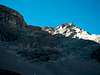 |  |  |
Route Description
From within the Pocaterra cirque, proceed directly south straight up to the Grizzly Col at 8500'. Take a breather and then continue up the east ridge of Tyrwhitt past the very interesting rock arch feature (the Window) and to the summit. Despite its published rating, I considered this summit an easy scramble and it took me just two hours from the car. There was a summit register in 2003.After enjoying the summit of Mount Tyrwhitt, downclimb a rock step to the ridge between Tyrwhitt and Mount Pocaterra. Ride the scree down and around to the left of the first problem and angle back right to the ridge. You will lose 1000' before you start gaining elevation again. This part of the scramble becomes more moderate with some narrow sections of the ridge. Two hours from Tyrwhitt, I bagged Pocaterra, which has two peaks and two registers? Your views include Mount Joffre to the west as well as the Misty Range of Mount Rae, Storm Mountain and Mount Arethusa to the east and Mount Elpoca to the north.
On the way up, I noticed a better descent then I discovered in the published route. Return the ridge to 9000' and a very unique gendarme and slip through the opening to the east side of the ridge. You must have good route finding skills to take this route. There is also objectionable hazard from rock fall, so speed would be essential. Zigzag your way down to the cirque on scree with one or two forced downclimbing spots and cross back south to the trail in the Pocaterra Cirque.