
-
 621 Hits
-
 75.81% Score
-
 6 Votes
|
|
Route |
|---|---|
|
|
38.62716°N / 106.3425°W |
|
|
Spring, Summer, Fall, Winter |
|
|
Overview
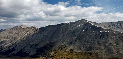
UN 13082 (Sawatch Range)
Elevation: 13,082
CO Rank: 596
CO 13er Rank: 543 of 584
Range: Sawatch
Lat/Lon 38.633, -106.33324
UN 13,082 is another Class 2 summit located at either the head of Pomeroy Gulch out of St. Elmo, Grizzly Gulch or the North Fork of the South Arkansas River and North Fork Reservoir. The old townsite of Hancock south of St. Elmo provides the only non-4WD access. All others require 4WD. We have sequenced UN 13,082 with Pomeroy Mountain with a trailhead start at the North Fork Reservoir. This provides for a very short & quick hike. UN 13,070 could also be combined with Grizzly Mountain for a much longer day from the same start. Lidar increased elevation by 12 feet.
 |
 |
 |
Getting There
North Fork Reservoir Campground:
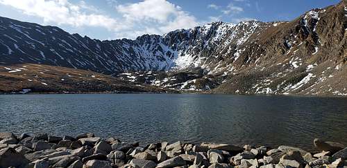
From Poncha Springs and the intersection of US285 and US50, head west approximately 6.6 miles on US 50 to the little town of Maysville and turn north onto County Road 240 which will become FR240. It's easy driving to the Angel of Shavano Campground and the crossing of the Colorado Trail on pavement. Beyond there, the road begins to degrade and ultimately becomes a slow, rocky affair. For the next 1.3 miles, maps show it as passable for passenger vehicles, but don't count on it. Best to just bring the 4WD with better clearance that can handle the rocky surface. It's 4.7 miles from the campground to the old townsite of Shavano and a trail that heads up Cyclone Creek. This could become an exit point for a climb of Grizzly or an alternate route. The USGS map amd FS2016 show an old roadbed/trail that heads up Cyclone Creek here, but the Trails Illustrated and San Isabel NF map do not show it. It has been in disuse long enough that iot's difficult to spot any of it on Google Earth. From the old townsite area of Shavano, it's another 2.25 miles to the North Fork Reservoir Campground, on the east side of the reservoir. This is a very limited facility with only about 8 sites. We are using it for the "trailhead," though the actual start to Grizzly is farther up the road if continuing on to Billings Lake. 4WD can be driven all the way to there. The start for Grizzly we suggest is about 2/3rds of the way up to Billings Lake. Drive or hike from the campground north on the road and begin the
Pomeroy Lakes:
From Buena Vista, head west on W Main Street toward W Lake Street for 0.8 miles. Turn left onto County Road 321/Rodeo Road and go 8.1 miles. Turn right onto County Road 162 and go 10.9 miles. Keep left to continue on Forest Road 295 and go 2.9 miles. Turn left onto Forest Road 297, Pomeroy Lakes 4WD road.
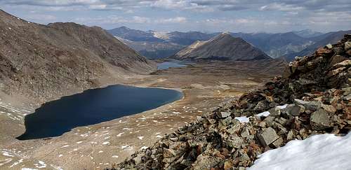
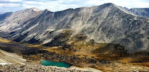
The rocky and bumpy road to the alpine lake is totally unpaved. It’s called Forest Service Road 297. It’s steep, long and moderately hard. A high clearance 4x4 vehicle is required. The ice does not completely melt on Upper Pomeroy Lake until late June or early July. Located in the Sawatch Mountains of central Colorado, the road to the lake is 6.05km (3.75 miles) starting from Forest Road 295. Vehicles are currently not permitted to drive to the lake.
The rocky 4x4 trail to the lake is usually open from around late June through sometime in October. This is a great trail that offers a little bit of everything -- rocky challenges, fantastic scenery, Colorado history, and access to some great hiking and fishing. 1.31 km (4,291ft) north of the lake you’ll find another lake: Lower Pomeroy Lake.
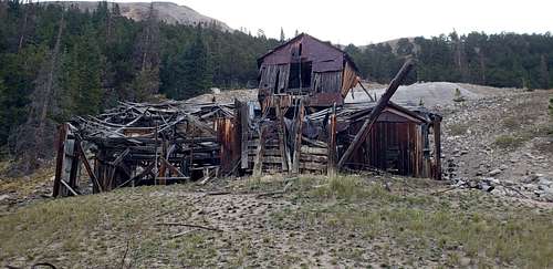
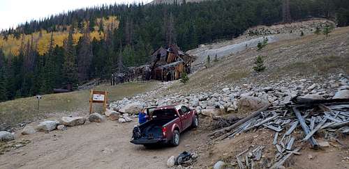
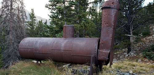
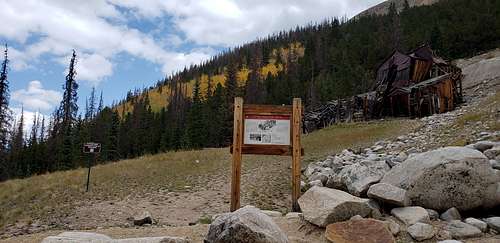
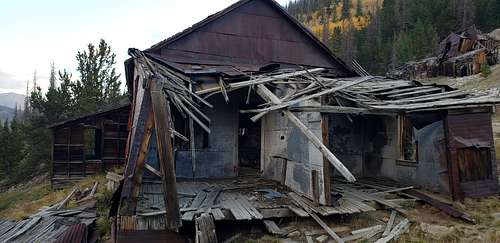
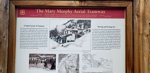
The Mary Murphy Mine
Chaffee County
The Mary Murphy began like many other mines in the Colorado Rocky Mountains. During the early 1870s, scattered gold and silver discoveries on the west side of the Arkansas River valley drew prospectors into the Collegiate Peaks. Such prospectors included John Royal, Abner E. Wright, and a third individual who headed up the Chalk Creek drainage in 1873. There they found a mineralized vein that carried gold, silver, and industrial metals, and the party claimed it as the Mary Murphy.
Mary Murphy Tramway Romley Terminal
The Romley Terminal is a component of a tramway built midway during the Mary Murphy Mine’s life. The tramway was built ca. 1891, making it among the earlier systems in central Colorado. Mines such as the Lady Murphy, Iron Chest, and other tunnels amid the Mary Murphy all had tramways crisscrossing to shipping stations, the mill at Romley, and the second-generation Mary Murphy Mill near St. Elmo. The Romley Terminal building played a fundamental role in the success of the Mary Murphy Mine and is a rare, surviving example of a bottom terminal for a Hallidie tramway system. This technology allowed mining companies to develop inaccessible veins that would have been otherwise unprofitable.
The Mary Murphy Mine was the principal gold mine of the Chalk Creek mining district of Chaffee County, Colorado, United States, near St. Elmo, Colorado. The Mary Murphy Mine operated continuously from 1870 to 1925, and produced 220 thousand ounces of gold, worth $4.4 million then (or about $180,000,000 in 2008), plus considerable silver, lead, and zinc. There were two aerial tramways connecting the mine to Romley, Colorado, and the Denver, South Park and Pacific Railroad.
In 1984 the Historic American Engineering Record recorded the structures then standing in the area.
Drainage from the old mine into Chalk Creek, a tributary of the Upper Arkansas River, would sometimes cause fish kills at Chalk Cliffs Rearing Unit, the state-run fish hatchery downstream, such as the kill of 800,000 fingerling trout in 1986. The Colorado Division of Minerals and Geology consolidated all of the surface wastes and capped them in a “high-and-dry” spot on the mill site. This reduced the dissolved metals levels enough to keep the fish kills from recurring. Since then, the site has been used as test-bed for new ways to treat harmful drainage from abandoned mines in the Colorado Rockies.
The Mary Murphy Mine is a popular destination for four-wheelers and ghost-town enthusiasts.
 |
 |
 |
 |
 |
 |
Route
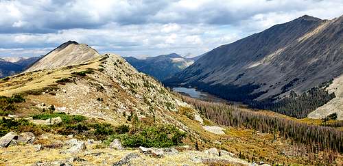
My approach to the summit was from Lower Pomeroy Lake. This is easy and very straightforward route to the summit. Follow well established traill to the Upper Polmeroy Lake, trail continues around lake aiming for lower spot on the ridge between Polmeroy Mountain and UN 13082. This class 2 hike will take from lower sadlle following ridge to the summit. Best way is to experince this route without much description.
 |
 |
 |
 |
 |
 |
UN 13,082 is sequenced with Pomeroy Mountain. One-way mileage and elevation gain are measured from the summit of Pomeroy. Round-trip mileage and elevation gain assume completion of the sequence.
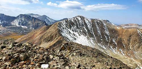
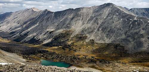
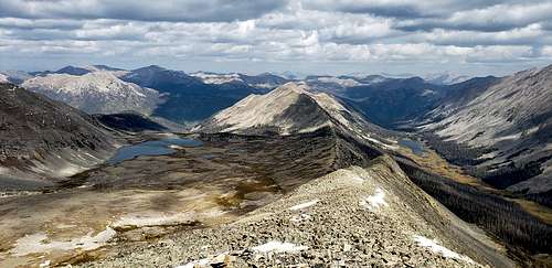
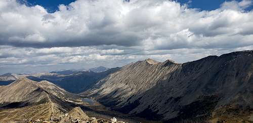
From the summit of Pomeroy Mountain, descend the ridge heading NE toward UN 13,082, staying generally on the south side of the ridge crest. The first part of the descent will be on the chiprock & talus. About 230 feet down in elevation, after crossing an area of some tundra, the ridge gets rougher with several rocky ribs to cross. This is the Class 2+ section. Once you reach the saddle, continue along the ridge, now more on the north side of the crest where you should find a use trail. The remainder of the hike is concluded on similar chiprock/rubble/talus. The summit is medium-sized rubble. It offers a great view of three drainages: the NorthFork, Pomeroy Gulch and Grizzly Gulch.
For the descent, continue SE along the ridge to a saddle just west of PT. 12,831. The trip down from the saddle can be very fast and aided by a snow and/or scree descent. Glissade on sandy scree (later season) into a rock field before picking up the remains of an old mining trail that will lead back to the road in the upper basin.
Red Tape
Pike-San Isabel National Forests &
Cimarron and Comanche National Grasslands
Forest Supervisor Office
2840 Kachina Drive
Pueblo, CO 81008
(719) 553-1400
When to Climb
Spring, Summer, Fall
Camping
Pomeroy Lakes:
Camping is permitted at least 100 feet away from the lakeshore at upper and lower Pomeroy Lakes. Afternoon and evening thundershowers are common at these high elevation lakes so come prepared with a warm sleeping bag and a sturdy tent.
North Fork Campground:
This campground is the highest elevation campground on the Salida Ranger District. The elevation is 11,000 feet and the campsites are situated on the north shore of the North Fork Reservoir. The road to the campground is very rough and not recommended for vehicles towing trailers. High clearance vehicles are a requirement for reaching this campground. No trash service.
At a Glance
| Current Conditions: | Opening date is tentative depending on road and snow conditions |
|---|---|
| Operational Hours: | Check out: 12 pm (noon) Quiet hours: 10 pm to 6 am |
| Reservations: | First-come, first-served. No reservations are accepted. |
| Fees: |
$18 per site for overnight camping. Two vehicles or one RV per site is included in the camping fee. $8.00 for a third vehicle. $8.00 fee for day use if not camping overnight. Fees are payable by cash, check or money order. Self-servicing fee tube is available. Sites must be occupied the first night of payment. Interagency Senior/Access passes valid for 50% discount to the camping fee for one site.
|
| Open Season: | June - Sept. |
| Restrictions: |
|
| Closest Towns: | Salida, CO |
| Water: | No |
| Restroom: | Vault toilet |
| Operated By: | Rocky Mountain Recreation Company |
| Information Center: | Visit Salida Ranger District or call at (719) 539-3591. |
External Links
https://www.14ers.com/php14ers/tripreport.php?trip=21927
https://peakbagger.com/peak.aspx?pid=60325
https://www.climb13ers.com/colorado-13ers/sawatch-range/map