Getting there
This isn't about the directions of how to get to this mountain, that is already done very nicely by the author of the SP page. No, this is more about how "I" got there. On friday, several of us had spent the greater part of a day getting up and down George Hansen Peak and as a result of getting off the peak later than we thought, we ended up not making it to this peak earlier on saturday since we had camped well short of Wendover.
Rather than go into details on the day, it will suffice to say we made it
to a good spot to camp later on Saturday, in the waning heat of the day. It was already starting to heat up in the west Utah desert and these aren't peaks you want to do in the middle of the day so we planned accordingly.
After finding a good spot to camp late on the 17th, we planned on getting an early start to beat the heat of the day (it had gotten to 92 on the 17th). An early start in this case was 6:30 a.m. Gjagiels had put together not only a helpful map but had ended up with probably the best route to the peak. None of us were anxious to repeat our George Hansen Peak effort and we looked forward to a "stroll" to the top of this one.
![Graham Peak Hike Overview]() gjagiels map
gjagiels mapThe hike
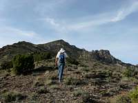
We managed to get about another mile up the 4wd road before we parked and started our walk. As pointed out by the route instructions, we aimed for a saddle on the north ridge. To get there we walked about a mile through the scrub brush and washes before getting onto a ridge that connected directly to the saddle. After about 2 miles, we hit the saddle and started up the northern ridge.
![Looking up the north ridge]() The northern ridge area
The northern ridge area
The heat began to rise and we were glad for the early start. One nice thing about this time of the year is that there is a fair amount of green on the hillsides and the snow covered appearence of Pilot Peak to the west helped
a bit to at least make you think you were cooler. It was pretty much just a walk uphill as nothing was difficult. A few areas were steeper than others and some rock talus areas were easily bypassed but eventually we started
working our way to the left around what I have referred to in a couple pics as the false summit. Just after traversing to the left, we had to drop down a bit to access the last couple of ridges that would lead to the summit.
![Heading for the summit]() After traversing to the left of the false summit
After traversing to the left of the false summit
Again, after one ridge was surmounted, we had a choice of either bypassing one of the last ridges either to the left or to the right. As we went up, we chose going to the right as seen in the next picture
Then there was just one ridge left and it led directly to the summit. A couple spots were rather airy but that just added to the charm of hiking up this last ridgeline. You could bypass the ridge on the east side but that took away most of the fun.
The summit
All the way up to the summit from the saddle from which we accessed the ridgeline from, we had noticed that there were survey stakes with the letters GRM stamped on metal discs. You can see on in the pic showing the benchmark.
![Graham Peak Benchmark (UT)]() Benchmark and metal disc
Benchmark and metal disc The summit itself was a fairly spacious area where all 4 of us could sit and enjoy the expansive views. A register was found and we made our presence known by signing in and we were aware that not many others had signed the register in the last 7 years so this is a pretty lonely summit most of the time.
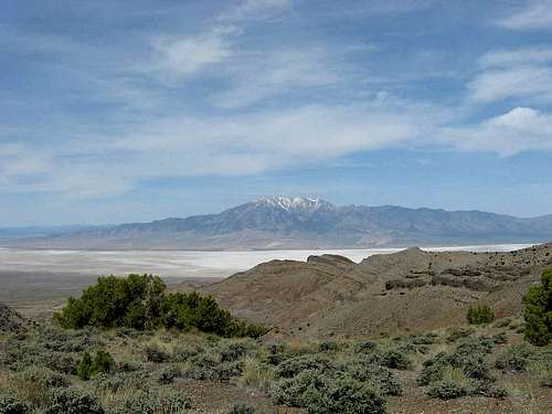
![Pilot Peak]() Looking over at Pilot Pk from the summit area
Looking over at Pilot Pk from the summit area
We must have spent close to an hour on the summit (it was nice and cool) but as always, what goes up, must go down. Again, the best part of the hike down was the walk back down the ridgeline. One of the things I noted was the whiteness of the salt flats against the rest of the scenery. Other mountain ranges looked liked islands floating atop the white but that is one of the aspects that makes this area so interesting.
![Heading down the ridge]() Heading down
Heading downAfterthoughts
![Heading down from the summit]() Heading down
Heading down
The trip back to the vehicle took about hours and that included several stops for just chatting and cooling off. Overall, I'd rate this hike very highly but it isn't one to do during the heat season as you could get your "brain fried" as one of the few entries in the register mentioned. The springtime is a great time to do this one as the hills are still decked out in green but plan on carrying alot of water as you don't want to get caught short on even a warm day. This was an enjoyable hike and I personally want to thank gjagiels for taking the time to put up the route as most likely, we would have attempted it from the south otherwise.
Mileage: 8 miles Elevation gain 2500 feet Time: roundtrip 5 hours overall
![Pilot Peak as seen]() From the ridge on the way down
From the ridge on the way down


Comments
Post a Comment