Intro & Overview
![Maloja-Soglio area]() Click here for on-line map!
Click here for on-line map!
![Piz Badile from Tombal meadow]() Piz Badile from Tombal
Piz Badile from TombalIntro
Normally, this should be a mountain page, but
Piz Cam, 2634 m, got its page on the SummitPost much later. So, now I'm attaching this page to it and this round tour becomes a part of it. But I did only the hike over the saddle, cca 2450 m, and did not ascend those additional, easy 200 meters up the grassy slope on Piz Cam. Even so we had a long, 12 hours trek, coming from Lake Lunghin and the summit of Piz Lunghin and continuing all the way to Soglio. For my injured knee those 2500 m of descent were more than enough that day, and I felt that already on the saddle, discarding all wishes to summit additionally also Piz Cam (later, in Soglio I almost fainted, because of pain in the knee or whatever other reason). So, if you know this place and are willing to add information, you can get and maintain this page.
Overview
Piz Cam, 2634 m, is not a high mountain. But it is so luckilly situated above
Val Bregaglia, that it offers one of the best views in the area. We are stading just opposite the big granite giants of Bergell mountains, and still more than 1500 meters above the valley. If the view was the only reason to visit Piz Cam, people could do only the here described round tour. And indeed it looks only a few do those additional 200 meters from the saddle on top. In winter and spring, Piz cam is also a nice goal for
tour skiing. Its upper (western) slopes are not steep, then comes a flat
Val da Cam, then 400 meters of a descent into
Val Maroz and finally out of it by a flat valley and a mountain road.
In summer and autumn, the
hike of Val da Cam is more popular. As said, it offers
great views on Bergell mountains (especially Albigna and Bondasca group), the high valley is very nice itself, and those shepherds huts above Soglio are unsurpassable - you can find pictures of them on all postcards of Val Bregaglia. The route is actually not a round tour, because coming by it from
Casaccia, 1458 m, to
Soglio, 1090 m, you will most likely finish it and return by
postal bus. Walking up (for example by the famous
'La Panoramica' path) would not add much (the views are the same) and would turn the tour into a very long day hike.
Getting There
We start the tour in
Casaccia, the highest village in
Val Bregaglia, before the valley rises up to
Maloja pass.
Val Bregaglia (
Bergell in German) can be reached by car from Milano (SS-36). The route is: Milano - Lecco - Chiavenna - Val Bregaglia (Casaccia village).
The other option is from the NE, so from Engadin (St. Moritz) and over Maloja pass down to Val Bregaglia (Casaccia).
Route Description
![Maroz Dent]() Maroz Dent
Maroz DentFrom
Casaccia, 1458 m, we go westwards, by the
mountain road, closed for public traffic, into
Val Maroz. In a few turns the road overcomes the valley step, then on some 1750 m the valley flattens and we soon reach
Maroz Dora, 1799 m. There one marked path deters right towards Septimerpass / Pass da Sett, but we continue by a flat valley in the western direction. Only a bit later the path ascends more considerably and we reach the inner shepherds huts -
Maroz Dent, 2035 m. They are a bit above the creek bed, so in continuation the marked path goes slightly down (towards the SW), crosses the creek and reaches an important
branching. The right path continues by the valley up (on Duan Pass), but we must go
left, towards
Val da Cam.
Above, it looks we shall reach a broad saddle - already from the distance we see a series of big
ciarns. But that is only a place, where the flat upper Val da Cam begins. The more steep lower slopes our path overcomes first with a few turns on the left side, then it crosses much towards the right (SW), crosses the water stream and finally gains in a southern direction the ciarns. The place is nice and panoramic and we hardly resist a short break.
![In Val da Cam]() In Val da Cam
In Val da Cam | ![Piz Mäder]() Piz Mäder
Piz Mäder | ![In the upper Val da Cam]() Upper Val da Cam
Upper Val da Cam |
The
upper Val da Cam is flat, but to the
highest point between
Piz Cam on the E and
Piz Duan on the W-NW we still need some walk up, perhaps good 100 m of altitude. The path turns down on the altitude of
2450 m (by some data 2463 m). Right below lies a small lake (
Lägh da Cam), and in front of us a
wonderful panorama opens. The whole northern flank of Val Masino (Bergell) group rises on the other side of Val Bregaglia.
![The great view from Plan Lo]() The great panorama from above Plan Lo
The great panorama from above Plan Lo
At first the path descends more considerably in the SW direction. But when we reach
Plan Lo with a few huts, the path starts a
long crossing of the southern slopes of Piz Duan. It goes all the time on the altitude of some
2100 meters, with great views. The path crosses steep grassy slopes, enters and exits several ravines (enough water on the tour), only in a few places it goes through light woods. Deep below the path we see a few huts, the majority of alpine meadows lies some 200 meters lower.
![Plan Lo]() Plan Lo
Plan Lo | ![Crossing the slopes of Piz Duan]() The crossing
The crossing | ![Val Bondasca beauties]() Beauties
Beauties |
Only towards the end of the crossing we reach a few houses and finally also the huts of
Cadrin, 2127 m. There, one path continues right up (on Duan Pass), but we are happy to finally start
descending towards the
left.
![Cadrin meadow]() Cadrin
Cadrin | ![Discarded]() Discarded
Discarded | ![On Cadrin meadow]() On Cadrin meadow
On Cadrin meadow |
At first we again lose only a little of altitude, and the path continues crossing the slopes again. Then on the next clearing it definitely turns down and so we reach the famous and picturesque alpine meadows:
Löbbia,
Brüsciä, then
Plan Vest, 1821 m, a step below
Tombal, 1550 m. From the lower edge of the latter we first see
Soglio, still deep below us. The path descends steeply into the woods, crosses towards the right considerably again and finally approaches the beautiful town from the NW side.
Return to Casaccia. We shall very likely take the
postal bus. It must be ordered, in the hotel (in the beautiful Salis palace) they will help you with information. The bus then descends to Promontogno in the main valley, where we switch on the other bus, driving towards Maloja.
Remark: As we came on Maroz Dora from the north (down from Septimerpass), and from there we continued the trek up the Val Maroz and over to Soglio, we did not do the part of the route from Casaccia to Maroz Dora. But it's only a mountain road anyway.
Basic Data
Altitude meters - up: 1100 m (some ups and downs, otherwise 1000 m).
Altitude meters - down: 1450 m.
Difficulty: Easy hike up and down by well beaten, marked paths, only on the crossing a few steeper slopes (by the SAC scale:
T2).
Times (altogether 6 h 30 min, plus bus transfer):
> Casaccia - Maroz Dent: 2 h,
> Maroz Dent - top of Val da Cam: 1 h 45 min,
> top of Val da Cam - Soglio: 2 h 45 min.

 8379 Hits
 78.27% Score
 9 Votes
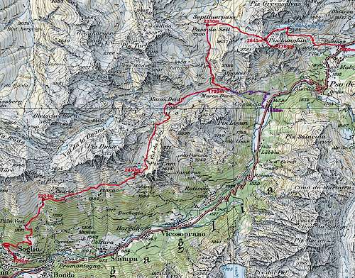 Click here for on-line map!
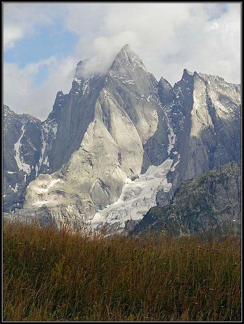 Piz Badile from Tombal
 Maroz Dent
 In Val da Cam
 Piz Mäder
 Upper Val da Cam
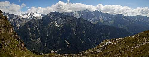 The great panorama from above Plan Lo
 Plan Lo
 The crossing
 Beauties
 Cadrin
 Discarded
 On Cadrin meadow
 Plan Vest
 Tombal
 Soglio