
-
 2507 Hits
-
 75.81% Score
-
 6 Votes
|
|
Route |
|---|---|
|
|
42.34655°N / 8.93020°E |
|
|
Download GPX » View Route on Map |
|
|
Hiking, Scrambling |
|
|
Summer, Fall |
|
|
Half a day |
|
|
Hike with UIAA II Chimney on top |
|
|
Class 4 |
|
|
Overview
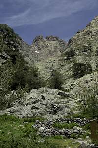
 Paglia Orba seen above the ruins of a shepherd's hut Paglia Orba seen above the ruins of a shepherd's hut |
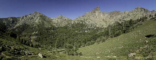
Among hikers and trekkers Corsica is best known for the long distance trekking trail GR20 which winds through the mountain ranges of Haute Corse. It's most difficult section (and there are many!) is the Cirque de la Solitude between Col Perdu and Bocca Borba, where it scales the highest range of the island. From Bocca Borba the trail follows Val de Viru, a beautiful valley with lots of cascades in Viru Creek.
Close by, starting from Val de Viru, there is the (often) pathless ascent to Monte Albanu one of Corsica's lesser 2000ers but one with an excellent view. It follows Val de Tilarba to Col de Tilarba and from there to the summit of the mountain.
The first section is a hike along a dirt road, in Val de Tilarba you find stone cairns but above Bergerie de Tilarba (a ruined shepherd's hut) the path vanishes for most of the time. A pathless scramble leads to Col de Tilarba, from where a rocky traverse takes you to the summit block of the mountain. The final ascent is a UIAA II climb through one of several chimneys which top out close to the top. The last steps are an airy and exposed traverse to the proper summit.
Getting There
See the main page. The hike with its two variations starts at Calasima, or rather beyond the village in a barely distinguishable parking lot.Route Description
 Punta Artica above Val de Viru
- Start altitude: 1096m
- Summit altitude: 2018m
- Prevailing exposure: W, later E
- Type: Hike and Scramble
nbsp; - Protection: None
From Calasima stay on the road running westward (also possible by car for some 4 km)). It turns northward and the paved part ends near an intersection: the left hand dirt road leads down to the Viru Creek while the right nahd road leads to Refuge de Ballone. For the ascent of Monte Albanu follow the right hand road. You can also use the left hand one but orientation is more difficult here. Better use it as the descent route (see description below).
Ascent through Val de Tilarba
As said above, follow the right hand dirt road for a while. Though there is a marked path to the left of the road (leading to Refuge de Ballone) rather stay on the road. After the third switchback (there's a long way between the first and second one) Val de Tilarba starts to unfold on your right hand side. You can see Cresta di l'Inzecche and Monte Albanu high above. Look for a stone cairn, which marks the entry to the path up Val de Tilarba.
 |  |  |
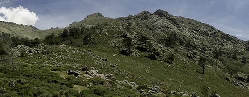
There is a marked path from the dirt road to the first ruined Bergerie (shepherd's hut(s)). However it is hard to find (or rather easy to lose) since it is only sparsely marked by cairns. For us cattle heading up the valley served as guides which led us to a clearly visible trail close to the bergerie. At the ruins the path splits: the left hand path will be the descent trail while the right hand one leads us up to Monte Albanu.
After the intersection the path gets more visible and heads up the valley in direction of Bergerie de Tilarba another ruined shepherd hut (or rather hamlet of huts). Right before the bergerie a path heads off for the west ridge of Monte Albanu but the intersection is far from obvious. Stay on the right hand (southern) side of the little creek, without visiting the ruins of the huts where all trails vanish. Maps claim there is a path leading to Capu Falu but we were not able to find it.
 Monte Albanu - the ascent route leads to the Col to its left
On the right hand side of the creek the path leads to a larger section of Corsican Macchia. As usual in the macchia trails vanish and you need to bushwhack to the other side. Head for the upper right corner (south-east), where - with a bit of luck - you can find the regular trail to Col de Tilarba. If you miss it you need to head for the col without a path, which is possible, but thanks to the steepness of the valley in this section, also quite strenuous. Undoubtedly you'll run into the correct path close to the col to which you follow it.
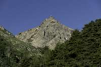
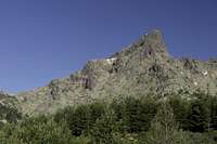
In Col de Tilarba turn right (south) onto a trail marked by cairns. It negotiates the brittle east slopes of Monte Albanu, heading for the saddle between the mountain and the Cinque Frati. It is easy to lose track here so look out for the cairns. In the saddle turn right (west) into a couloir. You can follow the couloir almost to the top (we did, it is a UIAA II - III chimney climb) but the easier route lies to the right. You have to scramble up to a ledge which heads along above the couloir, leading to the east ridge of the summit block. Here you need to descent into the notch above the couloir, then up again through a chimney (UIAA II). Another descent into the next notch and a short scramble takes you to the short but exposed summit ridge.
Descent Route using GR20
From the summit return the way you came (chimney, traverse to Col de Tilarba, Bergerie de Tilarba) until you reach the lower unnamed ruined shepherd's hut. There turn northward following a path which vanishes as it reaches the edge of a forest. Keep the direction until you reach a creek. Ford the creek (best spots to the right) and turn left following the creek on its way to Val de Viru for some 100m. Look for an abandoned dirt road leading north-westward through the forest and follow it. At its end it joins the road through Val de Viru. Soon a path turns off to the left and heads towards the Viru creek, which it reaches right underneath Bergerie de Ballone, one of the huts on the GR20 trekking trail.
 |  |  |
From the hut turn onto GR20 south which follows Val de Viru on its western side, through the forests at the base of Paglia Orba. Some good views develop southwards in direction of Punta Artica and eastwards towards Monte Albanu. Most impressive, however, is the upper end of Val de Viru, ending beneath Punta Minuta and Capo Rosso. The trail follows the slopes and cuts across a creek coming down from Paglia Orba.
In the next valley, right before GR20 starts heading up westward a trail marked with quite a lot of big stone cairns heads eastward, back dorn into Val de Viru. It follows a creek on its northern side, always high above the little canyon the creek has cut into the valley. There are several possibilities to descend towards the creek, which jumps from one (bathing) pool towards the next. Here good views of the Cinque Frati develop.
 |  |  |
The path, however stays high above the creek until it finally winds down towards Viru Creek right close to the confluence of the two creeks. Cross the shady glen (stepping stones in the rather large pools) and turn right and downwards on the opposite side. Again after about 100m you'll reach a dirt road heading up towards the road to the parking lot.