
-
 11699 Hits
-
 88.61% Score
-
 27 Votes
|
|
Area/Range |
|---|---|
|
|
46.40500°N / 11.70930°E |
|
|
Hiking, Trad Climbing, Sport Climbing, Scrambling, Via Ferrata |
|
|
Summer, Fall |
|
|
8651 ft / 2637 m |
|
|
Overview

Vallaccia (sometimes also spelled Valaccia) is the smallest subgroup of the Marmolada Group in the western Dolomites. As such it has its own section on the group page so why create a page about it? The simple answer is: look at the pictures and you'll know why. The more complicated answer is that this tiny group, which consists of about half a dozwn peaks / summits / towers is an explanation of what the Dolomites are all about. And instead of putting up the single summits which are all inside a 2km radius I decided to treat Vallaccia as one single mountain.
Lets start with the geography. Vallaccia is located to the south-west of the Marmolada Group at the western end of the Monzoni Ridge. It is separated from the ridge by Forcella la Costella, a pronounced pass, and the fact that it is composed of Schlern Dolomite whereas the Monzoni ridge is composed of everything else you can think of: sintered volcanic lava, porphyry and even flintstone among others.
Vallaccia on the other hand is pure Dolomite and is a perfect study for the history and geology of the whole mountain range. All of the Dolomite mountain groups used to be coral reefs in a sea which covered the area some 350 - 400 million years ago (which explains the almost identical summit elevations which all range between 2800m and 3200m with some notable exceptions). You find two kinds of structure all over the Dolomites which even today directly tell of that history: high plain ones (lagunes) and circular ones (atolls). The Gardenaccia, Sella and Pale di San Martino plateaus are examples for the former, the Sas Lonch / Langkofel / Sassolungo-, Latemar- and Vallaccia Groups for the latter.
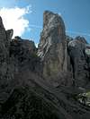
Now Vallaccia is a very special case due to its small size: though certainly not the highest of groups, here the circumference of the circle has moved so close together that it gives you the perfect Dolomite impression: 500m high walls in a circle with 500m diameter - you better not be claustrophobic.
The Vallaccia circle is open to the north where a tiny (today) creek has bitten away the rock. As you enter the cirque through this valley (which actually gave the group its name: Vallaccia) the walls close in and after some moderate climbing you find yourself surrounded by towers. There is one "escape" route out of this cirque other than the northern Vallaccia Valley and that is a steep scree couloir which leads to Forcella Vallaccia on the southern perimeter of the encompassing circle. And let me reccommend you not to take this route out of the cirque. We did and halfway up we wished we hadn't. But that is another story which will make it into a trip report soon.
While on the inside of the cirque you barely think of its outside, so awesome are the surrounding towers. If you look north you will find, however, that the valley is perfectly aligned to display this other circular Dolomite mountain Group the Sas Lonch / Langkofel / Sassolungo Group. But once outside on any of the encompassing mountains you will have perfect views of the surrounding groups, whether Dolomite ones or not. Just see the 360° panorama in the following section.
Now the question arises about climbing the Vallaccia towers: are there any routes? I must confess that I don't know. The rock certainly is solid and offers a good foundation for climbing but I could find no hints in any of my guidebooks. On the other hand a difficult ferrata crosses the western half of the encompassing circle: climbing Sas da le Dodesc from the centre and ending at Punta della Vallaccia. The ferrata is called the "Via Ferrata Franco Gadotti".
Finally: the names. As said above there are several spellings for Vallaccia itself: Vallaccia, Valacia, Valaccia. For the single summits you will find even more spellings. The mountain group is located on Ladinian Territory and the original names are in that rhaetian language. However, there is no unique spelling guide in Ladinian and Italian is not too different resulting in this confusion. Here I try to stick to Ladinian wherever I know the names. But it turns out that the spelling is different for the various valleys so please don't take them too literally.
 |  |  |  |  |
Views from the top
La VarellaColacSasso di RoccaGran VernelMarmoladaCime OmbrettaSasso VernaleCima UomoCostabellaP. delle SelleP. AllochetRizzoniSpiz di TariciognPale di San MartinoCima IuribruttoCima MalinvernoGrontonCatena di LagoraiPunta della VallacciaSas de la LunaLatemar GroupSas de StengiaSas AutRoda di VaelSas da le DodescCatinaccioVajolet TowersKesselkogelR o s e n g a r t e n / C a t i n a c c i o G r o u pLangkofel GroupSella Group
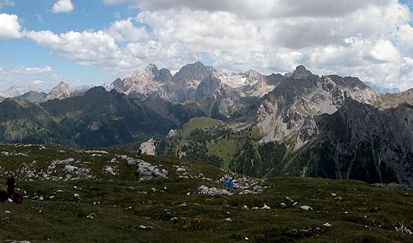 |  |  | 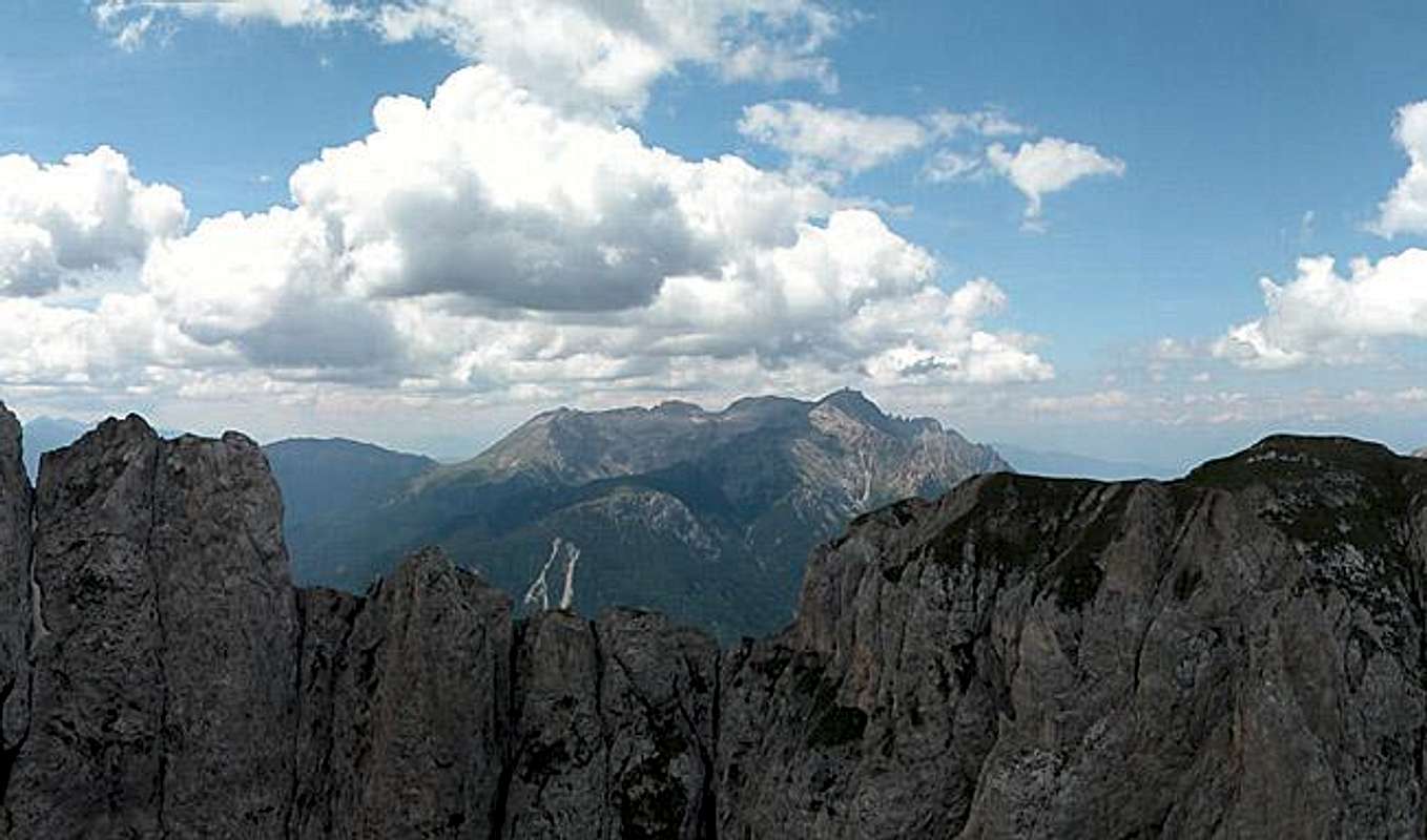 |  | 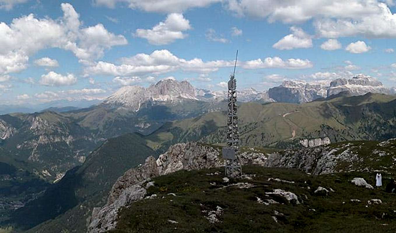 |
Vallaccia is perfectly situated to view all of the western Dolomites. The panorama above, which was taken from Sas da le Undesc, should give an imperssion. The Pale di San Martino- , Cima Bocche- and Lagorai Groups can be seen to the south, to the west it is Latemar and Rosengarten / Catinaccio, to the north yous see the Langkofel- and Sella Groups (with La Varella and Cunturines far behind whereas to the east Marmolada with its satellites can be seen.
 |  |  |  |  |
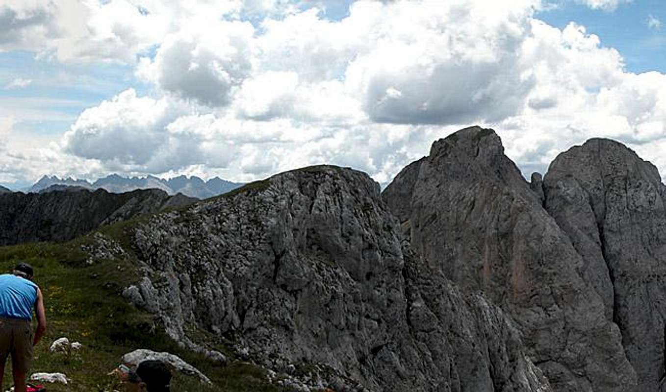
The Inside of Vallaccia

While the views from the top might seem impressive the actual must-see is the inside of the narrow cirque. I'm sure I will never forget this feeling of being shut off everything else. High walls encompass you to all sides but the northern one. And there - on a fine day - you'll see the Sas Lonch / Langofel / Sassolungo Group through the narrow Vallaccia Valley.
 |  |  |  |  |
The summits of Vallaccia
The summits are listed west to east.- Sas da le Dodesc (2443m)


- Sas da le Undesc da Vich (2176m)
- Sas Aut (2551m)

- Sas de Stengia (2546m)
- Sas de la Luna (2431m)


- Punta della Vallaccia (2639m)


- Sas da le Undesc (2503m)


- Torre Vallaccia (2514m)


- Sass Moriu (2318m)
- Sasso della Croce (2194m)
- Pizmeda (2199m)


Getting There

The best starting point for venturing to the inside or outside of Vallaccia is Pozza di Fassa to the north-west of the group. Moena to the south-west is also possible but from there the group is rarely climbed due to long ascent routes.
From the North (Brenner / Brennero)
Follow motorway A22 down to Cornedo (north of Bozen / Bolzano). There turn east on SS241 (Dolomite Highway) across Karerpass / Passo Carezza to Vigo di Fassa. At Vigo turn northward on SS48 which leads you to Pozza. In the centre of the town a small road leads into Val di San Nicolò. Either drive to its end at Malga di Crocefisso (outside approach) or already look for a parking space near the Vidor campground which is located just outside Pozza (inside approach)
From Verona
Take A22 north until the exit Ora / Auer. There turn east on SS48 direction Val die Fiemme which in the end will take you to Pozza. Turn east into Val di San Nicolò.
Red Tape
There is no red tape anywhere in the southern Marmolada Group. You are asked to take your refuse back with you and not to uproot any plants. In early summer you will find lots of orchids to the sides of the trails. Leave them where they are - they are protected. I'm not sure about Italy but in France and Germany you have to pay hefty fines if you are caught with orchids.When To Climb
The eastern half of the Vallaccia Circle can be climbed all year round. Sas da le Undesc would make a perfect ski tour destination. Maybe even Punta della Vallaccia, the highpoint can be reached. The remainder of the group should be climbed in dry and snow-free conditions only. This is particularly true of the scree couloir which leads to Forcella Vallaccia. This couloir rarely sees any sun so it will be covered with snow until late in the year. And I don't have to tell you that snow on scree is an explosive combination.Best times are early July through early September.
Accommodation
CampingThe closest campground is Vidor in Val di San Nicolò (trailhead for the inside for Vallaccia. Its address and the ones for the other nearby campgrounds are:
- Vidor
Località Vidor
Pozza di Fassa
Tel.: +39 0462.763247
Fax: +39 0462.764780
- Catinaccio
via Avisio 15
Pozza di Fassa
Tel.: +39 0462.763305
Fax: +39 0462.763501
- Soal
via Dolomiti 32
Pera di Fassa
Tel.: +39 0462.764519
Fax: +39 0462.764609
Other accommodation
The best information on boarding houses and hotels can be found on www.dolomiti.it. The site is not complete – you might find more information on local tourist web sites, but it already offers an impressive list. The following listing gives you an overview for the surrounding villages and towns:
Val di Fassa
Weather Conditions
Weather and avalanche conditions in Trentino:www.meteotrentino.it
Weather conditions Dolomites:www.dolomitimeteo.com
Maps 'n' Books
Books:- Climbing
- Classic Dolomite Climbs: 102 High Quality Rock-Climbs Between the Uiaa Grades III and VII (also available on CD)
Anette Kohler, Norbert Memmel
Mountaineers Books
ISBN: 0 8988 6693 6
- Classic Dolomite Climbs: 102 High Quality Rock-Climbs Between the Uiaa Grades III and VII (also available on CD)
- Vie Ferrate
- Klettersteige Dolomiten
H. Höfler, P. Werner
Rother Verlag
ISBN: 3 7633 3096 8
- Hülslers Klettersteigführer
E.E.Hülsler
Bruckmann Verlag
ISBN: 3 7654 4161 9
- Klettersteige Dolomiten
- Hiking and Trecking
- Höhenwege in den Dolomiten
H. Dumler
Bruckmann Verlag
ISBN: 3 7654 3860 X
- Dolomiten
P. Fleischmann
Kompass Verlag
ISBN: 3 8705 1409 4
- Dolomiten 4
F. Hauleitner
Rother Verlag
ISBN: 3-7633-4061-0
- Die Marmolata. Königin der Dolomiten. Führungen durch ihr Reich
L. Visentini
Athesia
ISBN: 8 8701 4172 1
- Höhenwege in den Dolomiten
Maps:
- Val di Fassa, Marmolada, Gruppo di Sella
Kompass Map WK 686
ISBN: 3 8549 1768 6
Scale: 1:25000
- Sellagruppe / Gruppo di Sella
Kompass Map WK 59
ISBN: 3 8549 1066 5
Scale: 1:50000