
|
|
Route |
|---|---|
|
|
42.69616°N / 0.46933°E |
|
|
Hiking, Mountaineering |
|
|
Spring, Summer, Fall |
|
|
A long day |
|
|
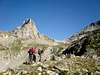
Overview
This is the southern route to the summit of Clarabide. A long uphill hike to gain over 1700 meters altitude, meaning -at least- a six hours effort to reach the summit. Apart from that, you must also count an additional four to five hours in order to get back to the parking area. Therefore, you might like to consider the idea to split the climb by spending a night at the refugio de Estós, placed about two hours and a half away from the car and some three hours before the summit.About difficulties, you will not find any real technical trouble. The hike along the valley of Estós is easy, suitable for any kind of public. After that, the path gets steeper and steeper on the Barranco de Gias. But it's always properly marked by lots of cairns and the only problems are a couple of easy scrambling points in the first hour after the hut and the uncomfortable walking on the scree slopes between the ibón de Gias and the Puerto de Gias. Not a place for novices in the high mountain to be alone in, but easy enough to offer a rewarding climb if they have experienced company.
Getting There
See the Clarabide main page for the trip to Benasque and the Estós parking area.Approaching the refugio de Estós
After leaving the parking area (1300 m) all we have to do is keep walking along the dirt road of the Estós valley. It’s part of the long distance trail GR11, but traffic of motor vehicles is not allowed (except for those specially authorised). The first remarkable reference you will find is a small dam and reservoir (embalse de Estós) left of the trail. Shortly after that, the trail crosses a bridge to reach the southern bank of the Estós river at the place known as Palanca de l'Aiguacari. Keep walking along the trail. Some 45 minutes after leaving the car you will pass by the small cabaña de Santa Ana (1540 m). This is a small hut, often open, that might be handy for shelter against unexpected rain or storms. Another 60 to 75 minutes walking will place us at the spot where the dirt road ends: a wide flat area known as Llanos del Turmo. There is another hut there, though it's a private property and usually closed by its owners. Behind that cabaña del Turmo, the GR11 trail keeps going west in search of the refugio de Estós and the col known as Puerto de Chistau. An additional thirty minutes hike will elapse before we reach the Refugio, an excellent halfway point if we wish to cut by half the long effort to reach the summit of Clarabide.
Route Description


Start walking uphill from the refugio de Estós, taking the small path placed behind the toilets. It will take you east-northeast at the beginning, going uphill along the steep Barranco de Gias. It's always properly marked by cairns and will soon turn north for a bigger altitude gain, towards some steep cliffs where you will have to cross the water stream to face a smooth slippery rocky area followed by an easy small chimney (consider it to be grade I UIAA for those not used to scrambling, but it's no trouble for anyone else). Then the path goes on winding along grassy prairies with lots of rocks and slabs for another hour -or so- to reach the Ibón inferior de Gias and the bigger Ibón de Gias (about 2600 m).
You will need to walk around the western bank of the lake, following the cairns, towards the col you can see to the northwest (between the rounded Clarabide Oriental and the huge wall of Gourgs Blancs). Panoramas will turn wider and wider as you approach the col. Once you get there and the lakes of Clarabide and Pouchergues stand under your feet, the final effort will be to turn southwest and follow the wide red ridge to reach Clarabide Oriental and Clarabide without any problems. The smaller Clarabide Occidental stands a little bit further, separated from the main summit by a small ridge with easy (but exposed!) scrambling.
For the way down you might like to consider a small steep path that reaches the ibón de Gias directly from the small col placed south of Clarabide and separating it from the rocky summit of Gias. That way, you could bag the fourth three-thousander in a day...
Essential Gear
In summer time there are no special gear needs. Of course, basic mountain and scrambling abilities are always required when we talk about these high summits. As well as good mountain boots, warm clothes, food and water. Hiking poles might also be handy to spare your knees some stress on the long way down.Whenever you are likely to find snow in the upper parts of the climb (winter, of course, but also in spring) remember to carry your crampons and ice axe as basic safety measures.