
-
 53720 Hits
-
 79.78% Score
-
 11 Votes
|
|
Area/Range |
|---|---|
|
|
32.63100°N / 116.0788°W |
|
|
Hiking, Trad Climbing, Sport Climbing, Toprope, Bouldering, Aid Climbing, Big Wall, Mixed, Scrambling |
|
|
Spring, Fall, Winter |
|
|
3400 ft / 1036 m |
|
|
Overview
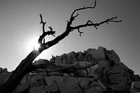
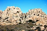
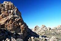
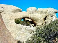
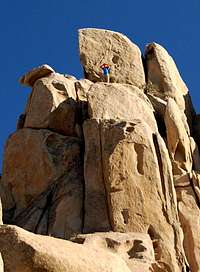
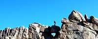
Located in the southwest corner of Imperial County, just steps from the San Diego County line and the Mexican border, sits one of the most amazing boulder-filled, climbing meccas in Southern California. When describing the Valley of the Moon, many make references to Joshua Tree and with its many large rocks and desert environment it's not hard to see why. Large granite outcroppings rise above the valley floor creating many opportunities for climbers and photographers alike. Nearby peaks, mines and caves make the area one of the most adventurous, explorable and scenic sites around. Managed by the Bureau of Land Management, Valley of the Moon is a short 4WD trip, or hike if you prefer, south off Interstate 8 in the Jacumba Mountains Wilderness.
Once a haven for bandits and smugglers, this remote section of wilderness still offers the added plus of being extremely close to the Mexico border, and is a favorite entry point for those smuggling illegal aliens. Desperate people sometimes do desperate things, so keep this in mind when climbing and hiking in the area.

Getting There
Reaching the Valley of the Moon may require a 4-wheel drive vehicle or a vehicle with adequate clearance. For those with neither, follow the below directions and hoof it or bike up the last mile or two into the Valley.
To Reach Valley of the Moon:
Exit Interstate 8 at In-Ko-Pah Park Road heading south. Turn right at the stop sign, heading west and drive 0.2 mile to enter a dirt road/parking area on the left. A small kiosk with a map marks the parking area and those with neither a 4WD or high clearance vehicle may wish to park here. If not there is also another small turnout .8 mile up the road for you to park. From the kiosk head east(left) on a dirt road that passes a small shack/trailer with several bird cages and old cars strewn about the front yard. After passing the residence the bumpy, deeply-rutted road heads south and southeast as it curves its way steeply up the hillside.
After a brief climb you'll pass several turnouts, the entrance to Smuggler's Cave and as the trail curves back south, west of the small peak named Quirk, you eventually come to a fork in the road. Take the road to the left. If you go right, the trail winds around and eventually leads up to Blue Angels Peak. After taking a left at the junction, follow the road southeast as it winds its way across a small valley towards Elliot Mine and the small peak named Tahe.
Eventually you come to another main junction The left road heads over to some inviting looking formations, but instead follow the road over some gulleys and then uphill. Bear left at the next junction and you'll reach a large parking/camping area, below a rock formation and just north of Tahe Peak and Elliot Mine. A small sign near the trail says "No motorized vehicles allowed," designating the western edge of the wilderness boundary. Park here and follow the trail south and east around the large mass of granite boulders just above the camping area to reach the entry to the Valley of the Moon.
The Climbs and Surrounding Peaks
Here's a direct link to a hand-drawn topo map of the area which includes locations, routes and pictures of all the climbs below and many more. North is the left side of the map as you look at the page. Courtesy of Chris Hubbard.
Also check out Perpetual Press Topo Rock Climbing Maps and Guide Service for links to topos, more pictures and additional beta of climbs in the Valley of the Moon.
Below is a list of rock climbs in the Valley of the Moon. Courtesy of ROCKCLIMBING.COM
Utilizing a five star rating system, this remote gem of a desert climbing area is situated right on the San Diego/Imperial County border. Some have said if a person were blindfolded and dumped off in Valley Of The Moon they would swear they were in Joshua Tree National Park. Tons of formations with rock quality ranging from fabulous to choss with most being quite good. Lots of sport climbs, trad routes. Unfortunately, although new route potential would seem to exist, most anything of value at Valley is located within designated wilderness and as such is no longer open to development (please be responsible and respect wilderness laws - let's keep this beautiful area open to climbers).
Gravity Wall:
Approach: this wall is best reached by walking around the far west side of the formations and turning back left through a corridor, then scrambling up and over numerous boulder-strewn sections before finally gaining the comfortable ledge below the routes. Somewhat ill-defined, this approach takes a bit of work. NOTE: Now that access issues with the BLM have been resolved, first ascent parties have elected to divulge the original names of their climbs. Routes are named from left to right. Please remember that this is designated wilderness and needs to be treated carefully!
ROUTES
A) Kepler's Thoughts 5.11a
B) Newton's Law 5.11b
C) Skate Away 5.10b
D) Heat's On 5.10d
E) Best Crack In The Moon 5.10a
F) Distant Warning 5.10d
G) Straight Shooter 5.10b
H) Paradigm Shift 5.11b
I) "Jack In The House" 5.12d
J) Sketch 5.11c
K) Einstein's Relativity 5.11d
Hawk Rock:
Hawk Rock, North facing, is characterized by a series of steep cracks and exposed face climbing. This crag has some of the most challenging crack and bolted routes on the best quality rock that Valley has to offer. NOTE: Now that access issues with the BLM have been resolved, first ascent parties have elected to divulge the original names of their climbs. Please remember that this is designated wilderness and needs to be treated carefully!
ROUTES
Fledgling Ledge 5.11b
Flesh Eaters 5.10c
Flying Lessons 5.12b
Hawk's Piss 5.10b
Swirling Swifts 5.10c
Talons Of Steel 5.11b
Patina Wall:
After hiking past Gravity Wall and heading south, a prominent corridor is visable on the right. Hike towards the Sundagger Wall (opposite Patina Wall), then back toward Patina Wall once at the base of Sundagger Wall. NOTE: Now that access issues with the BLM have been resolved, first ascent parties have elected to divulge the original names of their climbs. Routes are named from left to right. Please remember that this is designated wilderness and needs to be treated carefully!
ROUTES
Tech 9 (incorrectly named Fajita Patina) 5.9
A) S&W-60LS 5.10c
B) 870 Pump 5.10c
C) Have Guns Will Travel 5.11d
D) L1A1 5.11a
E) Full Auto 5.10d
F) Street Sweeper 5.11c
G) Tec 9 5.10a
H) Borderline (aka Mac 10) 5.10b
I) M 11 5.11c
J) A Call To Arms 5.11c
K) Big Turd Crack 5.7
L) Lend Me Your Guns 5.11d
The Fortress:
The chossiest crag at Valley, mostly because it just doesn't get climbed that often, but still very fun. North facing, bolted sport lines and mixed trad. NOTE: Now that access issues with the BLM have been resolved, first ascent parties have elected to divulge the original names of their climbs. Please remember that this is designated wilderness and needs to be treated carefully!
ROUTES
A) Zen Moves 5.11b
B) A Cut Above 5.12a
C) Seclusion Dweller 5.10a
D) Unknown 5.10d
E) Little Wave Dreams 5.10a
There are also numerous peaks in the vicinity including Blue Angel's Peak, Quirk, Tahe, Nopal, Whip, and Gold. All are easy Class I and II climbs.
Red Tape, Weather and Time to Climb
No Permits Required.
This section of BLM land is extremely close to the Mexico border, and is a favorite entry point for those smuggling illegal aliens so be aware of this. Border Patrol agents regularly patrol the area and you may come into contact with them. Be polite and they will too.
No discharging of firearms is permitted. People have reported this area as illegally being used as a shooting range.
Hunting, fishing, and non-commercial trapping are allowed under state and local laws.
Pet are allowed, but please keep your pets under control at all times.
Horses are permitted, however you may be required to carry feed.
Removal, disturbance, or attempting to remove archaelogical materials is a felony. Selling, receiving, purchasing, transporting, exchanging or offering to do so is prohibited by law.
For weather in the Jacumba area click HERE
Due to its desert climate, the best time to visit is fall-spring and when you do, make sure to drink plenty of fluids.
Camping
The Valley of the Moon area is open to camping and lies within the jurisdiction of the Bureau of Land Management, El Centro Resource Area.
Camping is permitted, limited to 14 days. After 14 days, campers must relocate at least 25 miles from previous site.
Help BLM preserve California's fragile deserts. Please park your vehicle or set up camp in previously disturbed sites.
Gathering wood for campfires, when permitted, is limited to dead and down materials. Do not cut live vegetation.
For more information check them out HERE or call them @ 760-337-4400.
External Links and Topo Map
My Photos of Valley of the Moon
Rockclimbing.com
Jerry Schad
San Diego Rock
