As every trip starts...
After a great weekend of snowboarding in Mammoth I was rearing to cinch on my hiking boots, hit the trail and explore some land on foot. My dad and my aunt April had both expressed an interest in exploring with me so I called them up both up and asked if they wanted to do some climbing. I had initially planned on climbing Viejas Mountain (SCSD County 100), which had captured my attention on a drive back from Cuyamaca, but before I cemented my plans my aunt called me back and asked if I had ever heard of a place called Valley of the Moon.
I quickly Googled it to see what I could find and I have to tell you, it looked amazing. “Just like Joshua Tree” was mentioned on nearly every site and from what I could see it definitely resembled it. Gigantic granite rocks jutted up and out from nearly every photo and it clearly looked like a place I wanted to explore. After a little more computer research and a quick glance through Schad I decided hiking the area was worthwhile and settled on a plan to explore the Valley and hopefully bag Blue Angels Peak in the process.
Trekking Valley of the Moon
I usually try to get an early start on my weekend rambles but my aunt was forced to work Saturday morning and we didn’t end up taking off from Rancho Bernardo until after 12. The drive down to Jacumba couldn’t have gone smoother. Traffic was light and the conversation was great. My aunt is one cool chick, lots of great stories and even better at handing out advice. Before I knew it we were pulling off Interstate 8 onto In-Ko-Pah Park Road and beginning the steep, rut-filled, dirt trail up into the hills towards our objective.
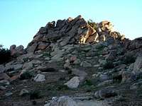
My 2WD Jeep did better than I expected climbing up Smuggler’s Cave Road. We soon passed the Smuggler’s Cave turnoff, rounded Quirk peak and could see southeast down the broad valley to Tahe Peak and Elliot Mine and off to Blue Angels Peak in the south. We parked the Jeep in a small turnout, did a once over on the topo map and headed for Valley of the Moon.
![Quirk to Valley of the Moon]()
Instead of following the Jeep trail that meanders through the valley, we decided to stick to the rocks and it made for a nice scramble as we worked our way southeast down the valley. My aunt had brought her little dog, Chili, with her and he actually did pretty well. She only had to help him over a couple of boulders and I have to admit I was pretty impressed. As we drew closer to Tahe Peak and Elliot mine I noticed a camping area off to the left and just below a massive pile of boulders. There were several people climbing the rocks above the camp and about 10 cars parked in the area. Not a lot of noise but we steered clear anyways. We hit a trail heading east just past the camp, which looked to head over the ridge between the camp and Tahe Peak, so we gave it a go.
![Arch before entering Valley of the Moon]()
![Valley of the Moon - Climbing away]()
As we rounded the small peak of boulders above the camp the view opened up and below us stood the Valley of the Moon. Giant piles of granite rose from the Valley floor and I could see now why so many people had compared it to Joshua Tree. It was eerily similar and just as beautiful. The number of climbs looked endless so I picked out a small half-dome looking rock in the distance and suggested we hike out to it.
We followed a trail for a ways across the valley floor but decided the rocks looked more fun so we boulder-hopped our way east. After a bit of climbing, my aunt wanted to focus on picture taking and I wanted to climb more so we went our separate ways. I scrambled up a few piles of rocks and was turned away by the exposure on a few others. I had left my gloves in the car and a few of the rocks were much sharper than I had expected. So of course, as fate would have it I was rewarded with a nice cut on the index finger of my right hand. It didn’t hurt much but it did bleed a little. After a few more tries I decided to hang up the rock climbing and went looking for my aunt. I still wanted to climb Blue Angels Peak and we were slowly losing the sun in the west.
The Border, Blue Angels Peak and Homeward Bound
My aunt hiked with me back across what we called the “Gateway” and climbed cross-country with me up a gully to the base of Blue Angels Peak. From here she waved me on and said she didn’t feel like climbing. This allowed me to pick up the pace a bit and I quickly climbed my way over the boulders to what I thought looked to be the highest peak on the western ridge. I came across a barbwire fence and immediately knew I was little too far south. Instead of heading north I decided to check out the US/Mexico border boundary marker first and then make my ascent on Blue Angel.
From the top of the ridge I could see the white obelisk of marker 231 across the gully. I quickly scrambled down the rocks, crossed the barbwire, snapped a couple of photos and was back across the border in a flash. In front of me, to the north, stood what looked to be two peaks of roughly the same height. I headed for the one that looked to have more elevation and of course I was wrong. I scoured the first, more southern summit looking for a marker, register or anything to mark the peak and there was nothing to be found. A little perturbed, I headed for the more northern of the two and came across the benchmark with SMUGGLER inscribed on it. Having read Bob Burd’s Trip Report I knew I was in the right place so I looked for the register. Instead what I found was a lot of trash, a few empty sleeping bags, a backpack, hundreds of empty water bottles and one half of the empty register can.
![US/Mexico Border south of Blue Angels Peak]()
![Looking at the Blue Angel s Peak summit]()
I hung out on the summit for a couple of minutes, taking in the views and snapping a few photos before I decided I needed to head back. My aunt was surely back to the car by now and I didn’t want to keep her waiting too long. I took a pretty direct descent off the peak heading for the Jeep trail just below Quirk Peak. The boulder hopping down was a lot of fun and when I finally reached the sandier portions I thought I was back in the snow. I jogged back up the trail to the Jeep just as the sun was disappearing behind the mountains.
![The trail back...]()
I was a little cautious driving the road back down, but the Jeep handled the ruts with no problems and soon we were rolling down the highway towards San Diego. We talked about dinner and reflected a little about our time at Valley of the Moon. I had a great time, my aunt had a good time and even Chili, curled up on the backseat, seemed to have had a good time. It was a fun little trip, but there’s still a lot to check out in that area and I’m sure I’ll be doing it again sometime soon.
Topo of my Route
Comments
No comments posted yet.