
-
 3138 Hits
-
 72.08% Score
-
 2 Votes
|
|
Route |
|---|---|
|
|
42.62449°N / 0.66591°E |
|
|
Download GPX » View Route on Map |
|
|
Mountaineering, Scrambling |
|
|
Spring, Summer, Fall |
|
|
A long day |
|
|
Class 4 |
|
|
P.D.inf. |
|
|
II |
|
|
Overview
 Pte de Coronas
The normal route is long and not always evident, and it's rare to find someone in this peaks (all the people go in direction to Aneto and you don't must to follow the route of Col de Coronas for Aneto). The peak is generally climbed in combination with Russell or Tempestades.
GPS file includes Tempestades and Russell.
Getting There
See the main page to approach to Puente de Coronas.Route Description
 West ridge
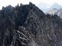 West ridge
In Puente de coronas we'll leave the Hut in right side walking the track with a barrier of wood. Very soon we'll reach the bifurcation with signal (left: Coronas, right:Llosás). We'll get the right (Llosás). After a long track with curves and zig-zag we'll reach a path near of the river. In the bridge we'll find a new signal with the text "Vallibierna" (it's the route to peak Vallibierna not for us). We'll leave the path of Vallibierna in this point turning to left side in a big plateau with some of water and little lakes. In the other side of the green plain we'll find some cairns of stones to ascend a hill to reach the wonderful Lake of Llosás. In left side we'll can to see the Ridge of Llosás and the col of Llosás but we'll turn to right bordering the lake to entry in a gorge. The exit of the gorge bring to a little lake where's we'll find new cairns to left side. In this area it's possible to walk in several paths with cairns but the first are the shortest route. After a confuse area with great ground of stone among the rocks we'll arrive to the morrena of the old glacier (the glacier don't exist nowadays and it's without snow in summer). The peak Tempestades is visible in left side. We'll approach to the bottom searching the pass among a lot of rocks.
 West ridge
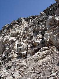 Channel East
This description is the same of route of Tempestades of course. To climb margalida we have two options from the place of rocks with Tempestades in left side and Russell in right side.
a)- The normal (P.D.inf. II): we search the point between Tempestades and Margalida (of course you must climbing Tempestades as well in first place if you want to conquer this great peak). The ridge west of Margalida is very cracked in this place and it's better the descent of a few of meters under the edge. We climb to the great block of stone to left side to the repises between the ridge, always in right side of the edge. The rock is good but the fall is impressive. Near of the summit you turn to left side over the north face in 2-3 meters before to return to our line of climb in right side. The descent is across the route b).
b)- Alternative: a good alternative is the entry in the point between Margalida and an aiguille over the Brecha Russell. The channel had a lot of stones and it's hard in ascent (useful normally as descent) but if you don't want to climb the longer exposed climb of the west it's the only access possible. In the ridge we turn to left (W.) to get the sharped East ridge and climbing the blocks (I+) we'll reach the summit.


Essential Gear
-For the beginners is very useful the use of the rope.-Crampons and ice-axe are advisables in spring (may-june) to approach to the ridge. The ridge don't has snow generally.