-
 9995 Hits
-
 74.01% Score
-
 4 Votes
|
|
Route |
|---|---|
|
|
42.36380°N / 19.35450°E |
|
|
Hike |
|
|
Half a day |
|
|
Walk-up |
|
|
Getting To Sirokar Lakovica
Driving by local road from Podgorica via Lijeva Rijeka to Matesevo (and Kolasin) after you come to Verusa turn eastwards to a non-paved road in direction of a children´s mountain resort in Verusa. After passing Verusa the road reaches a small pass between fields of river Verusa and that of katun Mokro. Continue by the same road, pass the houses of Mokro and also from the right side a branch off road toBukumirsko lake and Podgorica via Ubli. Your road then starts to climb and enters a limestone-carst area. After few long curves among rocky slopes of Maglic and Torac and 12 kms after leaving Verusa you will reach a plateau-like pass, area called Sirokar where summer shepherd houses of Ljakovic family are situated, thus forming katun Sirokar Lakovica (alt. 1765).Route Description
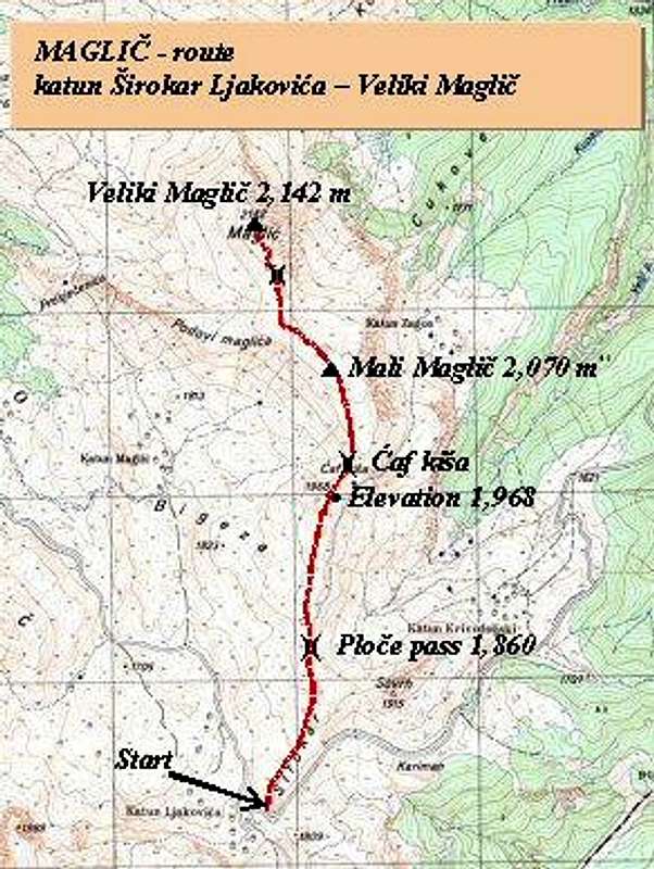
Because the route from Sirokar Ljakovica to Veliki Maglic follows elongated Maglic ridge and the walk is more into the length than to the height (377 m rise), you will not find it the climb to Veliki Maglic very difficult. Also along the most of the route the ground is grassy, without any trees and with minimum of rocky/stony terrain. Visibility of the route is absolute, and vistas around your climb are magnificent.Scheme of approach to Veliki Maglic from katun Sirokar Ljakovica
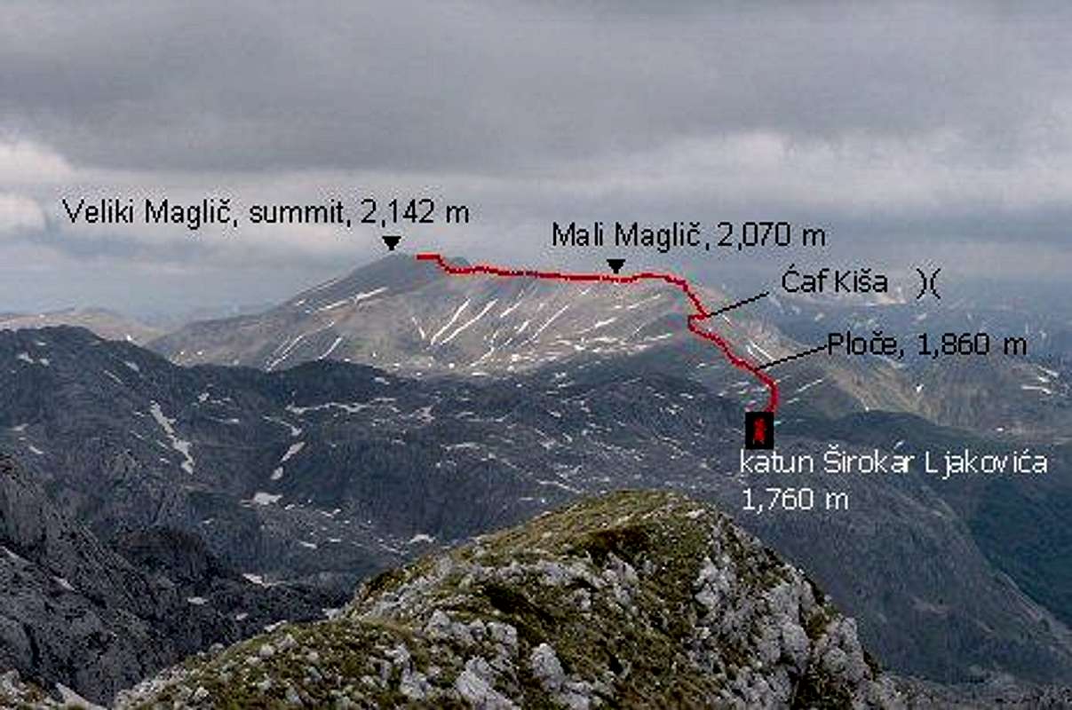
Sirokar Ljakovica – Veliki Maglic: 1:30 h
The route begins at katun Sirokar Ljakovica (1,760 m) situated on Sirokar plateau and mountain pass. This katun was in history one of two main main meeting places in mountains of Kucka krajina area, where members of Kuci klan were deciding on starting date of moving (so called „izdig“) their livestock to mountain summer houses - to so called „Upper mountains of Kuci“ – that means to the area around Komovi. Katun Sirokar Ljakovica was also called katun Grudski, in history.Where the last (northernmost) house of katun Sirokar Ljakovica stands, on the same non-paved road that is continuing futher to Komovi area, you take off the road (left) in northern direction along western edge of Sovrh (1,915 m, this peak was called Kariman previously).
After 15-20 minutes of walk over grassy terrain you get to small pass called Ploce (1,860 m). This is an area of limestone rocks, slabs (local word for it is „ploce“), carstic holes. After passing this part you get again onto grassy terrain to another of Maglic´s branching ridges. From this area on your left side you will see shepherds´ houses of katun Maglic. Next to katun Maglic is the source of Verusa river.
The trail follows this ridge and passes by the area Velje stijene (“Big rocks”, below the trail from right side) and circles around Dokin do (below trail in east direction). Dokin do („D“ read as „dge“ in English word „edge“) is the highest part of a field/plateau Sirokar Krivodoljski (1,700 m), where katun Krivodoljski is situated.
The trail still continues to climb along grassy ridge and reaches the elevation 1,968 m before small (almost imperceptible) descent to Caf Kisa (read: “tchaf kisha”, and „caf“ is Albanian word for a mountain pass) and after the pass there is a beginning of the final ascent to Mali Maglic mountain ridge.
On your ascent to Mali Maglic, still climbing along the grassy ridge you are passing by rocks slopes (on eastern side of Mali Maglic´s ridge) of Velje pecine („large caves“) and Viti obruc untill you finally reach the flat Mali Maglic mountain ridge. From katun Sirokar Ljakovica to this point you need about 1 hour.
You continue further, now in NW direction, walking easy along Mali Maglic (2,070 m) ridge to small mountain pass that separates it from Veliki Maglic, the highest summit of Maglic mountain. From the pass you need another 10-15 minutes to climb Veliki Maglic (2,142 m).
The same way back will take you additional 1 to 1:30 hours. You have more other options for return, many of them include downhill hike to non-paved road from Verusa, and then walk back to katun Sirokar Ljakovica.
Essential Gear
Standard hiking gear, depending on the season.Miscellaneous Info
If you have information about this route that doesn't pertain to any of the other sections, please add it here.Map