Trip Narrative and Itinerary
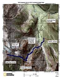
![Vesper Peak East Ridge topo]() Topo map of the route up the East Ridge of Vesper Peak via Sunrise Mine Trail and Headlee Pass. Click to enlarge, then click again to super-size.
Topo map of the route up the East Ridge of Vesper Peak via Sunrise Mine Trail and Headlee Pass. Click to enlarge, then click again to super-size. Synopsis: A glorious late-autumn hike followed by a snow scramble up Vesper Peak's gently sloping East Ridge. 3,900 feet of net elevation gain, from 2,300 feet at the trailhead to 6,200 feet at the summit.
Driving directions: From Granite Falls, Washington, drive east on the Mountain Loop Highway about 28 miles. Turn right onto Sunrise Mine Road 4065; small signs mark the turn. Drive about 2.3 miles to the road's end at the head of the Sunrise Mine Trail, elevation about 2,355 feet.
Approach: We hiked the rocky Sunrise Mine Trail south and then southwest through evergreen forests. The trail crossed two major streams in the first mile; the second of these was the main branch of the South Fork Stillaguamish River. The trail then crossed the north ridge of Morning Star Peak into the next valley west and followed its dry stream bed southward into a spectacular talus-filled cirque rimmed with cliffs. Behind a steep rib on the right, trail zig-zagged in short switchbacks up a steep, narrow, hidden ramp to Headlee Pass. The shady switchbacks were covered with a thin layer of slippery frozen snow, but enough rocks poked up through the snow to provide traction without crampons or ice axes.
A sign marked Headlee Pass. Beyond the pass, the trail turned northwest and traversed some open reddish talus flanking the south ridge of Sperry Peak. In about 1/3 mile it reached the outlet stream of the informally named Vesper Lake, which used to be a small glacier. As soon as we crossed the outlet stream -- the source of Vesper Creek -- the trail disappeared under several inches of snow. A few inches of soft but stable snow rested atop a much-firmer base. The softer surface layer was thick enough and soft enough to kick deep, stable steps.
The scramble: We scrambled up onto Vesper's East Ridge and followed its broad, gentle slope to the obvious summit. With snow so soft, the slope had no exposure that made me feel the need of an ice ax.
Vesper's summit consisted of a small pile of solid boulders. A gentle breeze blew -- the first hint of wind of the day. Some nascent high clouds foreshadowed bad weather later, but for now it was sunny and idyllic, probably in the low- to mid-fifties, as predicted.
I peeked down at the upper part of the North Face, which I'd hoped to climb last summer. Two or three inches of snow were plastered onto the face. Not very inviting. But Copper Lake looked spectacular and Glacier Peak was in full splendor.
We signed and replaced the register, took a few snapshots, enjoyed the spectacular view, and left. Taking our time on the descent, we stopped several times to snack, banter, and enjoy the views.
Times for us slower members of the group:
6:40 a.m. -- rendezvous for carpooling at Park-and-Ride at NE 70th St and I-405, Kirkland, WA
6:45 a.m. -- left rendezvous guzzling coffee and donuts
8:15 a.m. -- arrived at trailhead
8:28 a.m. -- started hiking
10:28 a.m. -- arrived at Headlee Pass
10:49 a.m. -- arrived at lake outlet stream
12:20 p.m. -- arrived at summit.
12:39 p.m. -- left summit
1:30 p.m. -- crossed lake outlet stream
2:00 p.m. -- photo opportunities at Headlee Pass
4:45 p.m. -- arrived back at trailhead
4:46 p.m. -- consumed 6-pack of Heinekin (except the driver, of course)
Snapshots (click photo twice to supersize)
Headlee Pass
![Headlee Pass]() A weathered sign welcomes Michael Knoll to Headlee Pass, a narrow notch in the dramatic ridge connecting Sperry Peak to Morning Star Peak. The 4,720-foot pass is the portal between the drainages of the South Fork Stillaguamish River and Vesper Creek, which empties into the Sultan River. Photo by Matt Rudolf (I think), October 28, 2007.
A weathered sign welcomes Michael Knoll to Headlee Pass, a narrow notch in the dramatic ridge connecting Sperry Peak to Morning Star Peak. The 4,720-foot pass is the portal between the drainages of the South Fork Stillaguamish River and Vesper Creek, which empties into the Sultan River. Photo by Matt Rudolf (I think), October 28, 2007.Summit
![Vesper s summit]() A pair of pointed boulders forms the 6,214-foot summit of Vesper Peak. Front, from left: Michael Knoll (scrambling to beat the camera's self-timer), Matt Rudolf, and Craig Reininger. Above: John Gebhart. Photo by Michael Knoll, October 28, 2007.
A pair of pointed boulders forms the 6,214-foot summit of Vesper Peak. Front, from left: Michael Knoll (scrambling to beat the camera's self-timer), Matt Rudolf, and Craig Reininger. Above: John Gebhart. Photo by Michael Knoll, October 28, 2007.Keep on truckin'!
![Keep on truckin !]() John Gebhart, on the first hike of his life, demonstrates the plunge step on the East Ridge of Vesper Peak. Gebhart, who labors in obscurity as a backup guitar player for the meteoric singing career of his 17-year-old daughter, recently launched his own solo musical career. His solo recordings can be heard at www.myspace.com/gebsings. Gebhart's hobbies include cycling in the RAMROD (Ride Around Mount Rainier in One Day) and raising venture capital for nascent software companies. On most of Vesper's East Ridge, the snow was deep enough for good footing and even a few short standing glissades. Several inches of soft newer snow had partly consolidated atop a firm base. Ice axes were unnecessary and avalanche danger appeared to be very low. Photo by Michael Knoll, October 28, 2007.
John Gebhart, on the first hike of his life, demonstrates the plunge step on the East Ridge of Vesper Peak. Gebhart, who labors in obscurity as a backup guitar player for the meteoric singing career of his 17-year-old daughter, recently launched his own solo musical career. His solo recordings can be heard at www.myspace.com/gebsings. Gebhart's hobbies include cycling in the RAMROD (Ride Around Mount Rainier in One Day) and raising venture capital for nascent software companies. On most of Vesper's East Ridge, the snow was deep enough for good footing and even a few short standing glissades. Several inches of soft newer snow had partly consolidated atop a firm base. Ice axes were unnecessary and avalanche danger appeared to be very low. Photo by Michael Knoll, October 28, 2007.The Glacier is gone.
![The Glacier is Gone]() Just a few decades ago, a quarter-mile-wide glacier nestled in this cirque between Sperry Peak and Vesper Peak. Now it's a lake. As the water's surface starts to freeze over for the winter, John Gebhart, left, and Craig Reininger pause to enjoy views and a snack. Photo by Michael Knoll, October 28, 2007.
Just a few decades ago, a quarter-mile-wide glacier nestled in this cirque between Sperry Peak and Vesper Peak. Now it's a lake. As the water's surface starts to freeze over for the winter, John Gebhart, left, and Craig Reininger pause to enjoy views and a snack. Photo by Michael Knoll, October 28, 2007.Logisics
Vehicle: We rode in a big SUV, but the road was passable enough for a normal passenger car.
Footwear: John and I were glad we wore our heavy climbing boots; they worked well for stiff-heeled plunge-steps on the way down the ridge and for kicking steps in the snow on the way up. Matt wore sneaker-like approach shoes, which worked okay on the trail but not so well in the snow and for stream crossings. I think he may have preferred his La Sportiva Makalus.
Water: Two big streams in the first mile, then it was pretty much dry untiil we got to the lake's outlet stream, which had a very substantial flow.
Road condition: Bare and dry.
Trail condition: Unusually rocky, but very distinct at least to the lake. Very few deadfalls to detour.
Weather: Mid-thirties in the morning, highs probably in mid-fifties. Sunny most of the day. Dead calm over most of the route; a gentle breeze at the summit.
Snow cover: snow-free to about 4,200 feet, then one inch of compact frozen snow and ice on the trail switchbacking up the ramp east of Headlee Pass. Mostly bare with some patches of thin snow from Headlee Pass to the lake outlet. Four to eight inches of snow from the lake outlet to near the summit, with some windblown bare patches and bare rocks showing through. Ice ax optional. Less experienced hikers might want ice ax or trekking poles for balance.
Crowds: One car at the trailhead. Its occupants started before us and scrambled Sperry Peak. They passed us at Headlee Pass on the descent. The snow on the trail had lots of tracks from earlier parties, and there were multiple sets of footprints going up the East Ridge to Vesper's summit.
Permits and registration: Self-registration by sign-in at the trailhead. No permit required. We displayed a forest pass on the dashboard in case it was required for parking.
Comments
No comments posted yet.