
-
 10654 Hits
-
 83.69% Score
-
 17 Votes
|
|
Route |
|---|---|
|
|
34.29701°N / 118.02847°W |
|
|
Hiking |
|
|
Spring, Summer, Fall, Winter |
|
|
Less than two hours |
|
|
trail |
|
|
Overview
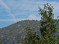
Vetter Mountain (5,908 feet), formerly called Pine Mountain, is located in the San Gabriel Mountains Front Range west of the San Gabriel Wilderness. It is the location of one of the very few still manned fire lookouts in the San Gabriels. Its summit can be reached easily from the Charlton Flats picnic area off the Angeles Crest Highway by fire roads or a short, about 1.5 mile hike through a beautiful conifer forest. The views from the lookout on the top are marvelous on clear days. If you meet some of the volunteer staff in the lookout, take your time, talk to them and listen to some great stories. I have nothing but utmost respect for them.
Little History
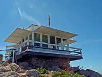
The United States Forest Service (USFS) built a fire lookout on top of Vetter Mountain consisting of a 14' by 14' wood cab in 1935. From 1955 to 1981, Ramona Merwin, her daughter Joyce and son Jerry lived in the lookout and worked as the last paid Fire Lookouts of Vetter Mountain. Fantastic stories about her life at the lookout can be read here. The Vetter Mountain Lookout was closed in 1981 and at one time there was a plan to move the entire Lookout building to Chilao Visitor Center, but a group of active citizens in cooperation with the Forest Service were able to rebuild, restore, and return the tower to operational service in 1998. Ramona Merwin and her family was invited to the opening ceremony on May 30, 1998 and made the first call, "Dispatch... Vetter Mountain in service". The Vetter Lookout tower has been open ever since during the fire season from May to November. Today the tower is operated by the Angeles National Forest Fire Lookout Association (ANFFLA) citizen volunteers in cooperation with the USDA Forest Service.
Route Description
The geography of Vetter Mountain is interesting as it marks the transition from the "Chaparral" zone to the south to the “Montaine” zone to the north. The chaparral zone is found on the hot, dry, south facing slopes of the foothills of the San Gabriel Mountains. Plants are chest height, dense, prickly, and evergreen; typically contains chamise, yucca, ceanothus, scrub oak, laurel sumac, sages white and black, poison oak, and in the higher elevations, manzanita and mountain mahogany. The montaine zone consists mostly of bigcone spruce, canyon oak, Jeffrey pine, sugar pine, incense cedar and white fir.

The short trail starts from the Lower Charlton Flats Picnic Area (5,240 feet) and is marked by a sign just before the road closure. The trail follows a small ravine and crosses after a few hundred yards the Silver Moccasin Trail, which is a 53 miles long trail in the San Gabriel Mountains starting at either Chantry Flats or Clear Creek to the top of Mt. Baden-Powell and down to Vincent Gap. Go straight here and follow the mostly dried-up creek uphill in west/southwest direction through beautiful Ponderosa, Jeffrey and Sugar Pines, along with Western Red Cedar, Oaks, Manzanita and some Coulter Pines. You will cross the fire roads up to Vetter Mountain twice but the trail is well marked. During spring time/early summer plenty of blooming yuccas and the amazingly stunning snow plant can be seen. After a little bit over one mile the trail turns to the south and gets markedly steeper. After a few switchbacks you top out on the fire road just below the fire lookout.
From the summit you have beautiful views over the San Gabriel Mountains, from San Gabriel Peak, Mount Wilson to the west/southwest, Fox Mountain #2, Condor Peak in the distance to the west, Mount Gleason and Pacifico to the north/northwest, Mount Waterman and Twin Peaks to the north/northeast, and the peaks around Mount Baldy to the east/southeast. Listen to the great stories from the volunteers at the lookout, look at the historical pictures, show your appreciation for their volunteer-work, and head back the way you came or take one of the fire roads back to the Charlton Flats picnic area.
The trail is short, about 1.5 miles one-way with a little bit less than 700 feet of elevation gain. It’s great for children but be careful with rattlesnakes.
Getting There
From LaCanada Flintridge follow the Angeles Crest Highway for 23 miles to Charlton Flats. Turn onto Charlton Flats picnic area road and go right at the junction to the lower parking area. Drive to the end of the parking area until you reach a road gate, where the trail up Vetter Mountain is marked with a sign. Park in one of the parking spots and display you National Forest Adventure Pass. One note of caution: when you drive on these mountain highways (Crest or Forest Highway) be sure to stay on the right side of the road at all times. These roads are very, very popular with bikers who often times veer into the middle of the road especially in curves. There have been many near-fatal or fatal accidents because both bikers and cars met in the middle of the road.
Weather
Essential Gear
No essential gear is necessary.External Links
Ramona Mervin
Mount Vetter Fire Lookout
Angeles National Forest Fire Lookout Association