
-
 11812 Hits
-
 78.27% Score
-
 9 Votes
|
|
Route |
|---|---|
|
|
39.64290°N / 105.7827°W |
|
|
Hiking, Scrambling |
|
|
Summer |
|
|
Half a day |
|
|
Class 2 Hiking with Class 3 Scrambling Options |
|
|
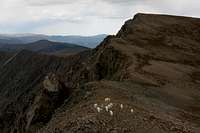 Land of mountain goats...
With 4WD, these are the easiest ways to the summits of McClellan and Edwards.
Please note: Photo captions have information relevant to the routes. Please click on the pictures to access those details.
McClellan SW Ridge
4WD is required for this one unless you plan to hike from Waldorf, adding at least 1500' and 4.5 miles (RT) to your climb. From Georgetown, drive the Guanella Pass Scenic Byway (many signs in town point the way) 2.5 miles, where you turn right onto a rocky road after a major switchback. This is the Leavenworth Creek Road, and it may not be signed. It is narrow and rocky for 6 miles to the Waldorf site, but there are no grades or obstacles that require anything beyond just high clearance. At Waldorf, the road bends right to climb up and around a tailings pile (watch for nails). Bear left when the road forks (the right fork starts climbing very steeply toward McClellan along the old tourist route discussed in the Overview section).
From here, it is 2.3 miles to Argentine Pass, which is at 13,200'; there are two or three intersections along the way, but always stay on the wider, more-used road (248.1V). This is the portion of the drive that does require 4WD, and some sections are best done in 4-Low. The road continues to be rocky and has very tight switchbacks, steep sections, and a few chewed-up spots that may have you scraping the underside (skid plates are very nice to have on this road). The toughest spot is at the last switchback before the pass, where you must negotiate some large rocks or try bypassing them in a narrow off-camber move.
I have driven the road in a stock Jeep Wrangler and a stock Nissan Xterra; larger vehicles will have a difficult time with the switchbacks, and SUVs not really made for off-road driving (meaning most SUVs) may have trouble with the grade or may take a beating underneath, so be warned. This road is nothing like the infamous Como Road in the Sangre De Cristos, but it does have a moderate rating, which means it likely will be difficult and/or frightening for inexperienced off-road drivers.
From Argentine Pass, it is a Class 2 hike of about 4 miles RT to the summit of McClellan Mountain, with an overall elevation gain of approximately 600' (to the summit, less on the return hike). The difficulty is really Class 1, but I'm calling it Class 2 since it is not an established trail and does require that one occasionally looks up to see where he is going.

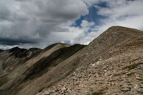
Follow cairns along the Continental Divide over Point 13,484 and along the gentle, slightly undulating ridgeline to the saddle directly beneath the summit of Mount Edwards, and then hike cross-country to the 13,400' saddle between Edwards and McClellan, from which it is maybe one half of a mile and 200' to McClellan's summit. The first two photos in the left column of this section show views of McClellan from the approach along the Divide.
 From Edwards
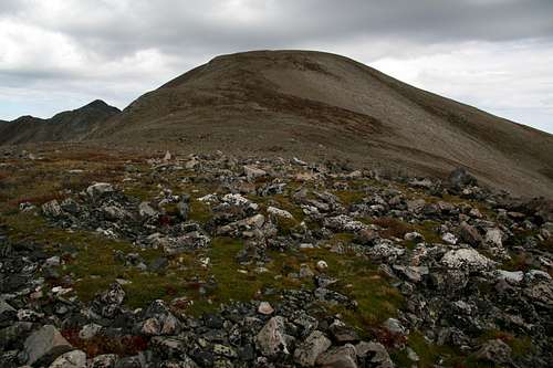
In my opinion, it is actually easier, even though it involves about another 400' of elevation gain, to hike up to Mount Edwards and then follow its northeastern ridgeline to the Edwards-McClellan saddle. This avoids the awkward "sidehill" hiking that is so brutal on the ankles. Plus, Edwards is one of Colorado's 100 highest peaks, and it seems a shame not to summit it when it is so close and so easy to do.
 West face
I found an interesting alternative to the straight hiking by dropping from McClellan's southwest ridge onto the mountain's rugged west face. There was a fun pinnacle to scramble up (Class 3, formation shown in some pictures on this page's gallery, including one displayed below), and there were many Class 3 variations for regaining the ridge just shy of the summit. The rock is loose here, so be very cautious even though the climbing itself is not technically difficult.

To Edwards
Refer to the directions above for getting to Argentine Pass.
Argentine Pass also provides easy access to Mount Edwards.
From the pass, it is a Class 2 hike of about 1.5 miles, with 700-800' of elevation gain (minor dips make it hard to judge more exactly without the use of a GPS or similar device).
Follow cairns along the Continental Divide over Point 13,484 and along the gentle, slightly undulating ridgeline to Edwards. There is a path to follow almost the entire way, though it mostly disappears for the final push up to the summit. The difficulty is Class 1, but the lack of a formal trail is my reason for calling this a Class 2 route.

Alternate Route from Horseshoe Basin
 Chalky-white Creek in Horseshoe Basin
This is good if you do not have 4WD or want the effort you exert to reach either mountain to be a little more respectable than what is required when Argentine Pass is the starting point.
From U.S. 6 at the eastern end of Keystone, take the signed road to Montezuma. This road is easy to find if one is traveling eastbound, but there is no direct access to it for westbound travelers, who will have to watch for the road and then make a U-turn to get to it.
At 4.3 miles from U.S. 6, look for a parking area on the left. Beside it, a dirt road heads east. This is the Peru Creek Road, and it is passable to passenger cars for approximately 5 miles, after which the road becomes markedly steeper and rougher, soon requiring high clearance and 4WD if one is to continue on. The Peru Creek Road becomes a very scenic drive after about 3 miles, passing many relics of the area’s mining heyday as it climbs through an open, verdant alpine basin, through which runs a chalk-white stream colored by calcium carried by the water. Peru Creek and some of its tributaries often strongly resemble the glacial streams that one finds in the Canadian Rockies.
There is a good-sized parking area on the left side of the road at 4.7 miles (11,100’), and this is a good spot to park a passenger car. There is a gate (open in the summer) at 4.8 miles, and at 5 miles is the trailhead for Argentine Pass (11,300’-- the TH, not the pass), which also has some parking and is about as far up the road as one should go in a passenger car.
Hike the Class 1 trail for about 2.5 miles and 1900' to the pass, and then follow the routes described above.
Essential Gear
I did this route, including the scrambling on the west face, in hiking sandals. A helmet is not a bad idea if you KNOW you will be checking out some of the scrambling; the rock is loose, and mountain goats that might be above you will increase the risk of rockfall. It is often windy along these ridges, and weather changes quickly, so have a waterproof jacket and long pants.
Route Diagrams
 Route Diagram for Edwards Hike
 Click and enlarge for more detail.