
|
|
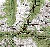
Route |
|---|---|
|
|
39.78600°N / 105.822°W |
|
|
Hike |
|
|
Most of a day |
|
|
Class 1-2 |
|
|
Approach
The trailhead is at Berthoud Pass which is on mile marker 243 on Highway 40. Berthoud Pass can be reached from the north and Fraser and Winter Park or from the south and Empire. The Empire exit off I-70 is exit 233 for those driving from the south. Park at the now closed Berthoud Pass Ski Resort parking lot. The trailhead is across the highway. Highway 40 is open and plowed year round allowing easy year-round access to the trailhead.Route Description
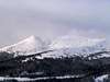
Note: I did this route in late fall-early winter (November 15, 2003) and with a deep snowpack, so be aware that in summer, descriptions of the route may vary slightly.From the trailhead, follow the blocked-off road up the slope to the west. In winter, you will find a well beaten path in the snow (made by snowboarders) that heads directly up the slope without the switchbacks. In summer, stay on the road to avoid erosion. Timberline is reached at 11,600 feet. The rest of the route is above timberline, so be aware of gathering thunder-clouds in the summer time. Simply follow the road/ridge up the west up the moderate grade until the road ends at about 12,200 feet elevation. A foot trail continues west to point 12,391. There are spectacular views in all directions from the point.
There is a trail junction at this point,and the trail to the north (right) heads toward Twin Cones. The trail to Vasquez Peak heads left then follows the ridge southwest along a gentle grade. Though the ridge is gentle, it can be very windy at any time of year and is no place to be with thunder clouds gathering, so be aware of the weather conditions. The trail bypasses the gentle summits of points 12,424 and 12,507 before reaching Stanley Mountain (12,521), but peak-baggers will probably take the few extra minutes to ascend them (the main trail also bypasses the summit of Stanley Mountain by a short distance, but the summit is obvious). Mount Stanley is reached after 3.5 miles from Berthoud Pass and has spectacular views in all directions.
From the summit of Stanley Mountain, it is possible and highly recommended that you continue west to Vasquez Peak, assuming you have the time and energy.


Essential Gear
In summer only a good pair of boots are needed. Snowbanks usually exist through the summer.In winter, snowshoes annd ski poles are a definate help below the timberline, but once you reach timberline, most of the snow is blown and compacted by the wind. An ice axe is also recomended. Crampons are not required, but can be helpful if parts of the route is iced up. As long as you stay right on the ridge top, avalanche danger is usually very low throughout the winter. The slopes on the side of either side of the ridge are very avalanche prone, so stay on the ridgetop in the winter!