
|
|
Route |
|---|---|
|
|
38.64445°N / 106.41748°W |
|
|
Mountaineering |
|
|
Summer |
|
|
Most of a day |
|
|
Hike |
|
|
Getting There
Directions to the ghost town of Hancock:From the town of Buena Vista drive 8 miles south on Route 285 to a place known as Nathrop and then turn west onto Route 162. Drive this road 15.3 miles to just before the ghost town of St. Elmo (the first 10 miles are paved and the rest is a well graded dirt road).
Turn left onto Route 295. This road is rougher but is still passable by most/any car. Continue 2.7 miles until you see a detour around an old decaying railroad bridge (The detour is rather steep and the road beyond it is much rougher. I did not need to use 4 wheel drive but I will probably not drive this road in anything less than an SUV). Continue another 2.8 miles to the remains of the old mining town of Hancock
Route Description
All distances are per my GPSPlace…………….Elevation………………..Distance
Hancock…………11050 ft…………………Zero
Tunnel……………11600 ft…………………2.6 miles
Helmers…………..12858 ft…………………1.0 miles
Total………………………………………….3.6 miles
On the west side of the ghost town of Hancock you will see a sign for the Alpine Tunnel Trail. (The sign says 3 miles to the tunnel but my GPS showed 2.6 miles). This trail is closed to motorized vehicles.
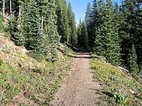
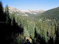
Follow the trail in a beautiful pine forest. You will go past a sign that talks about the dangerous curve on the old railroad where trains derailed on multiple occasions. Farther up, another sign talks about the methods of winter snow removal on the railroad track. You will soon reach the rocky northern slopes of Mt Poor. This is a beautiful section of the route. Mt. Helmers will not be in view. Make sure you do not mistake Peak 12954 ft or Peak 12850 ft for Helmers.
Helmers not seen

Helmers

Talus
Just before the east entrance of the tunnel, you will see a sign on the left side for the trail to Tunnel Lake. Leave the old railroad bed trail and follow this trail up a wide switchback to above the tree-line to near the saddle between Helmers & Poor. Helmers will come to view for the first time. You will then leave the trail and follow a direct route up the slopes of the summit of Helmers. You migght encounter a section of steep talus.