
-
 4291 Hits
-
 78.27% Score
-
 9 Votes
|
|
Route |
|---|---|
|
|
37.93070°N / 107.4933°W |
|
|
Hiking, Scrambling |
|
|
Spring, Summer, Fall |
|
|
Half a day |
|
|
Overview
 Purple Aster & Butterflies
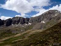
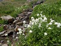
This scenic route provides a lot of bang for the buck. A gently-graded trail whisks you quickly and smoothly into a high basin full of wildflowers (in season) and abounding with dynamite views! The relatively brief off-trail segments are above timberline and provide excellent line-of-sight (conditions permitting) navigation. The views from the top of Whitecross Mountain, combined with the relative ease of attaining the summit, might have you laughing out loud at your good fortune.
While many hit Whitecross Mountain as an afterthought following a visit to the top of nearby 14er Handies Peak, this route takes in Whitecross Mountain as the main attraction. This easy-moderate route will have you back in Lake City in plenty of time for a cold beer and burger at Packer Saloon and Cannibal Grill, or wherever your taste buds steer you.
Roundtrip Distance: 7.6 miles
Elevation Gain: 3,100
YDS Class: 2+
Planning Map: Trails Illustrated #141 | Telluride, Silverton, Ouray, Lake City
 Upper Basin Wildflowers Upper Basin Wildflowers |  Tundra Wildflowers Tundra Wildflowers |
Getting There
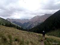
 In the woods on trail In the woods on trail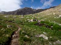 Handies Peak above the basin Handies Peak above the basin | From Lake City, Colorado… • Drive southbound on CO 149 for a couple of miles out of town • Head right on CR 30 (toward Cinnamon Pass). Note signs indicating you are on the Alpine Loop. • Continue on CR 30 around the west side of Lake San Cristobal • Follow CR 30 as it turns into a Forest Service road for approximately 16 miles to the Silver Creek | Grizzly Gulch trailhead Note: High clearance and 4x4 are must haves in wet, snowy or muddle conditions, but are nice-to-haves in dry conditions. Most standard passenger vehicles could make it to this trailhead, but the road is quite rough in spots and the more clearance and traction your vehicle has, the happier you will be. Segments of this road are a narrow shelf road (around the lower slopes of Sunshine Peak), so be prepared if this type of driving makes you squeamish. Keep your speed under control and be mindful of oncoming traffic when rounding corners. |  |
Route Description
 Mid-trail rock outcrops Mid-trail rock outcrops |  Mid-trail views Mid-trail views |  Whitecross Mountain hovers above Whitecross Mountain hovers above |  Whitecross Mountain above the gulch Whitecross Mountain above the gulch |
Along Grizzly Gulch Trail
• Leaving the trailhead, head west across a footbridge up the Grizzly Gulch trail.
• Pass first across some gentle terrain through meadows and shrubs.
• The trail gains elevation steeply when you first enter the forest, then relents as it continues to ascend the drainage.
• Follow the Grizzly Gulch trail for a total of 2 miles from the trailhead into the mid-basin.
• Here the trail makes a sharp switchback to gain the ridge between Handie Peak and Whitecross Mountain.
• Ride the trail about halfway up to the ridgeline.
 San Juan talus
 Easy scampering
After Leaving the Trail
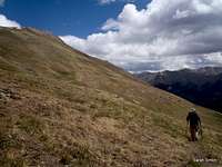
• Roughly halfway to the ridgeline, after the start of the switchback, leave the trail to head north across the tundra toward Whitecross Mountain’s southwest ridge. You may note existing use trails (whether used by boots or hooves or both is uncertain.)
• A little slipping and sliding through screen is required to gain the ridge.
• Once the ridge is gained, it’s just ½ mile to the summit!
• Ride the ridgeline, following a faint herdpath through the talus.
• Very close to the summit, the ridgeline broadens a bit, but globs of weathered granite bar easy foot passage.
• Simple scampering through these outcrops, with some elevation loss and regain, will lead you to the summit. The highpoint is to the northwesternmost of these knobs (to climber’s left).
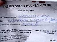
• At the time of my visit, the apex was marked by a cairn and a PVC summit register.
 |  |  |  |
 |  |  |  |
 |  |  |  |
Essential Gear
 Beautiful basin!
• Outerwear appropriate to the season
• Map, compass & GPS
• Colorado Gazetteer for road navigation
• Flotation in snow season
• An ice axe and crampons both to gain the ridge and then to safely navigate the ridge in snow season
 |  |