
-
 10325 Hits
-
 80.49% Score
-
 12 Votes
|
|
Route |
|---|---|
|
|
39.74170°N / 105.8822°W |
|
|
Download GPX » View Route on Map |
|
|
Hiking |
|
|
Spring, Summer, Fall, Winter |
|
|
Most of a day |
|
|
Overview
 Along the Continental Divide
This route begins near the hustle and bustle of I-70, but quickly leaves behind the chaos to be enveloped in dark forest. When Herman Gulch opens up and the route leaves the trees, the views are astounding. The basin surrounding Herman Lake, lorded over by Pettingell Peak and neighboring “The Citadel” will take your breath away. The route crest on the Continental Divide, from which the eyes are overwhelmed in every direction by views of hundreds of mountains near and far. The Continental Divide Trail, overlapping the Herman Gulch Trail, facilitates travel for all of this route (in the summer) and most of the route (in the winter). The basin is chock-full of wildflowers in the summer and a white winter wonderland in snow season. In addition to dynamite views, however, the Continental Divide is infamous for its winds – be prepared to weather the elements regardless of the season.
Note: Do not enter Herman Gulch in periods of considerable or higher avalanche danger as this narrow valley is hemmed in by numerous evident slide chutes coming down from Machebeuf Peak and Mount Bethel. Additionally, the upper parts of the route following the Continental Divide are prone to cornice formation and should be approached with caution in snow season.
Roundtrip Distance: 10 miles
Net Elevation Gain: 3,000 feet (cumulative gain will be higher)
YDS Class: 1 (summer); 2 (winter, due to off-trail navigation to avoid slide-prone slopes)
Planning Map: Trails Illustrated #104 Idaho Springs | Georgetown | Loveland Pass
Getting There
 Herman Gulch Trail
 Continental Divide Trail
The Herman Gulch Trailhead sits just off I-70 and is accessible via paved or graded gravel roadbed to all motor vehicles in most conditions. (In other words, if your vehicle can make it this far on I-70, conditions permitting, it can make it to the trailhead.)
The trailhead is at Exit 218, just three miles west of Bakerville.
Route Description
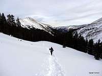
For mapping and elevation profile, please refer to the attached GPX file.| Lower on the route - snow and Jays | |||
|---|---|---|---|
 |  |  |  |
• Leave the trailhead heading uphill north and northeast first on an old sawmill road.
• The trail narrows and soon you reach the fork with the Watrous Gulch Trail. Continue left on the Herman Gulch Trail / Continental Divide Trail.
| Gaining the ridge that grants passage to the Continental Divide...and even more heavenly views | |||
|---|---|---|---|
 |  |  |  |
• Continue over two miles to just below and east of Herman Lake. Here the Continental Divide Trail takes a sharp eastern turn.
• In the summer, simply follow the Continental Divide Trail until you reach the summit of “Hassel Peak.” Here, however, I will detail the winter route description.
• In snow season, depart the trail and ascend northeasterly to gain the ridge before you. The ridge is rocky, sometimes loose and steep in spots, but at least during our visit, did not hold much snow.
| Upon reaching the Continental Divide, the views simplly explode! | |||
|---|---|---|---|
 |  |  |  |
• Ride this ridge curving first west and then north until you reach a plateau nearing the Continental Divide. Here, turn right / begin heading north toward your goal.
• Follow this broad, wide-open ridgeline over a false summit to the top of “Hassell Peak. The Continental Divide Trail closely hugs, well, the Continental Divide, and this is where you will wish to be during snow season, anyhow. This ridge is prone to cornice formation thanks to prevailing westerly winds, so select your footing carefully!
| The broad, open summit of UN 13215 "Hassell Peak" is a fine place to take in views of a sea of surrounding mountains | |||
|---|---|---|---|
 |  |  | |
• During our visit, the summit of “Hassell Peak” was marked by two twin cairns, enabling us to step onto the summit as if walking through a welcoming gateway.
| Enjoyable cruising along the Continental Divide south of "Hassell Peak," just keep an eye out for cornices and windloading | |||
|---|---|---|---|
 |  |  | |
Essential Gear
| The descent into the cold winter sun | |||
|---|---|---|---|
 |  |  |  |
 At the summit
 Snow Devil
• Map & compass
• Comfortable hiking boots or shoes
• Outerwear appropriate to the season, especially wind protection and insulation for along the ridgeline
• Snowshoes or skis in snow season
• Water and snacks
• A camera to save memories of the high country views
• First aid kit
• Other standard backcountry essentials